Ranger, Georgia facts for kids
Quick facts for kids
Ranger, Georgia
|
|
|---|---|

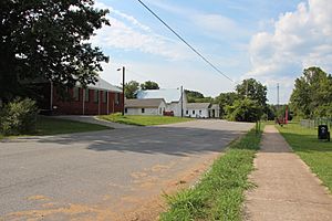
Church Street
|
|

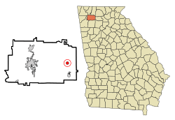
Location in Gordon County and the state of Georgia
|
|
| Country | United States |
| State | Georgia |
| County | Gordon |
| Area | |
| • Total | 0.82 sq mi (2.11 km2) |
| • Land | 0.82 sq mi (2.11 km2) |
| • Water | 0.00 sq mi (0.00 km2) |
| Elevation | 748 ft (228 m) |
| Population
(2020)
|
|
| • Total | 107 |
| • Density | 131.13/sq mi (50.62/km2) |
| Time zone | UTC-5 (Eastern (EST)) |
| • Summer (DST) | UTC-4 (EDT) |
| ZIP code |
30734
|
| Area code(s) | 706/762 |
| FIPS code | 13-63560 |
| GNIS feature ID | 0332791 |
Ranger is a small place in Gordon County, Georgia, in the United States. It's called an unincorporated community, which means it's not officially a town or city with its own local government. Instead, the county government handles its services. In 2020, about 107 people lived there.
Contents
History of Ranger
A post office opened in Ranger way back in 1891. People aren't completely sure how Ranger got its name. It might have been named after another town called Ranger, North Carolina. Or, it could have been named after the Confederate rangers, who were like soldiers during the American Civil War.
In 1910, the Georgia General Assembly (which is like Georgia's state parliament) officially made Ranger a town. This meant it had its own local government.
However, on May 3, 2023, Ranger stopped being an official town. The Governor Brian Kemp signed a new law. This happened because the town hadn't provided services like police or utilities for a long time. Also, it hadn't held an election since 2005. Now, Gordon County provides all the government services for the people living in Ranger.
Geography of Ranger
Ranger is located in the eastern part of Gordon County. You can find it at these coordinates: 34°30′1″N 84°42′41″W / 34.50028°N 84.71139°W.
U.S. Route 411 is a main road that goes right through the middle of Ranger. If you go north on this road, you'll reach Chatsworth about 19 miles away. If you go south, you'll get to Fairmount in about 5 miles.
The United States Census Bureau says that Ranger covers a total area of about 2.1 square kilometers (or 0.82 square miles). All of this area is land; there's no water within its boundaries.
Population and People
| Historical population | |||
|---|---|---|---|
| Census | Pop. | %± | |
| 1920 | 145 | — | |
| 1930 | 143 | −1.4% | |
| 1940 | 160 | 11.9% | |
| 1950 | 183 | 14.4% | |
| 1960 | 161 | −12.0% | |
| 1970 | 140 | −13.0% | |
| 1980 | 171 | 22.1% | |
| 1990 | 153 | −10.5% | |
| 2000 | 85 | −44.4% | |
| 2010 | 131 | 54.1% | |
| 2020 | 107 | −18.3% | |
| U.S. Decennial Census | |||
The number of people living in Ranger has changed over the years. In 2010, there were 131 people. By 2020, the population had gone down to 107 people.
In 2010, there were 46 households and 39 families living in Ranger. A household means all the people living in one home. A family is a group of people related by birth, marriage, or adoption living together.
Back in 2000, there were 85 people living in Ranger. Most of the people living there were White. A small number, about 2.35%, were Hispanic or Latino.
The average age of people in Ranger in 2000 was 50 years old. This means half the people were younger than 50, and half were older.
Famous People from Ranger
- Tom Graves: He was a U.S. congressman, which means he was a politician who represented Georgia in the United States Congress.
- Robert D. McTeer: He was an economist, someone who studies how money, goods, and services are produced and used.
See also
 In Spanish: Ranger (Georgia) para niños
 | Percy Lavon Julian |
 | Katherine Johnson |
 | George Washington Carver |
 | Annie Easley |

