
Rapperswil facts for kids
Quick facts for kids
Rapperswil
|
||
|---|---|---|

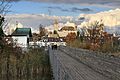
Rapperswil as seen from Etzel mountain: Capuchin monastery to the left, Rapperswil castle and St. John's church in the background, Lake Zürich harbour and Altstadt in the foreground respectively Seedamm, wooden bridge and upper Lake Zürich to the right (October 2010)
|
||
|
||

Rapperswil
Location in Switzerland

Rapperswil
Location in Canton of St. Gallen
|
||
| Country | Switzerland | |
| Canton | St. Gallen | |
| District | See-Gaster | |
| Municipality | Rapperswil-Jona | |
| Area | ||
| • Total | 1.74 km2 (0.67 sq mi) | |
| Elevation | 409 m (1,342 ft) | |
| Population
(December 2006)
|
||
| • Total | 7,601 | |
| • Density | 4,368/km2 (11,310/sq mi) | |
| Postal code |
8640
|
|
| Surrounded by | Altendorf (SZ), Freienbach (SZ), Jona, Bollingen, Lachen (SZ) | |

Rapperswil, often called Rappi for short, is a cool town in Switzerland. It used to be its own town, but since 2007, it's part of a bigger place called Rapperswil-Jona. You can find it in the canton of St. Gallen. Rapperswil is special because it sits right between two parts of Lake Zürich: the Obersee (upper lake) and the main part of the lake.
Contents
Discover Rapperswil: A Town of Roses
Where is Rapperswil?
Rapperswil is on the northern side of Lake Zürich. The lake is split in two by a narrow strip of land called the Seedamm. This land bridge was formed by ice ages long ago. Part of Rapperswil's old town, its castle, and a monastery are located on a small piece of land that sticks out into the lake, like a mini-island.
Amazing Sights to See


Rapperswil is famous for its beautiful sights, especially in the old town, known as the Altstadt. You can walk through its old streets and discover many cool places.
Some of the main attractions include:
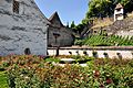
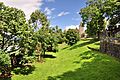
- Rose Gardens: Rapperswil is known as the "town of roses" because it has so many beautiful rose gardens. From June to October, you can see over 15,000 rose plants of 600 different types! There's even a special rose garden in the town center that's easy for people with disabilities to visit.
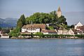
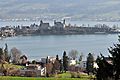
- Rapperswil Castle: This old castle sits high on a rocky hill overlooking Lake Zürich. It was first built around the early 1200s. It was destroyed once in 1350 but quickly rebuilt. Today, the castle is home to the Polish National Museum. You might even spot some deer living around the castle grounds!
- Wooden Bridge: There's a cool rebuilt wooden bridge that crosses the lake to a place called Hurden. It has a small chapel on it called Heilig Hüsli.
- Capuchin Monastery: This small monastery was built in 1606. It's still used by monks today.
- Churches: The main churches are the Roman Catholic St. John's Church (from the 1200s) and a small Protestant church.
- Circus Knie: The national Circus Knie has its main home in Rapperswil. They also have a Circus Museum and Knie's Kinderzoo, which is a zoo especially for kids!
Getting Around Rapperswil
You can easily travel around Rapperswil and the surrounding areas.
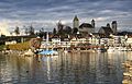
- Boats: The ZSG operates passenger boats on Lake Zürich. These boats connect Rapperswil with other towns around the lake, including Zürich-Bürkliplatz.
- Trains: Rapperswil railway station is a busy train hub. You can catch trains like the Voralpen Express and several Zürich S-Bahn lines (S5, S7, S15, S40). It's a quick 36-minute train ride to Zürich Hauptbahnhof (Zurich's main train station).
- Buses: Local bus services help you get around Rapperswil-Jona and to nearby villages.
Rapperswil's Long History
|
Lordship (County) of Rapperswil
Herrschaft (Grafschaft) Rapperswil
|
|||||||||
|---|---|---|---|---|---|---|---|---|---|
| 1220–1464 | |||||||||
 Juliusbanner (1512)
 Coat of arms
|
|||||||||
| Status | State of the Holy Roman Empire | ||||||||
| Capital | Rapperswil | ||||||||
| Government | Principality | ||||||||
| Historical era | Middle Ages, Early Modern period | ||||||||
|
• Rapperswil founded
|
1229 (official date) | ||||||||
|
• Lordship established
|
ca 1233 1220 | ||||||||
|
• Inherited by counts of
Habsburg-Laufenburg |
1309–58 |
||||||||
|
• Purchased liberty from
Austria |
1415–58 |
||||||||
1440–46 |
|||||||||
|
• Condominium of the
Old Swiss Confederacy |
1458–1798 |
||||||||
|
1798 1464 |
|||||||||
|
• Joined St Gallen
|
19 February 1803 | ||||||||
|
|||||||||
Rapperswil has a very long history, with people living in the area for at least 5,000 years!
Ancient Times
Archaeologists have found signs of old settlements and even a very early wooden bridge from 1523 BC. This bridge crossed the lake to Hurden. These ancient lake settlements are so important that they are part of a UNESCO World Heritage Site called "Prehistoric Pile dwellings around the Alps".
Later, the Romans built a trading center called Centum Prata (meaning '100 meadows') nearby. This shows how important the area was for trade and travel even back then.
The Counts of Rapperswil
The famous Rapperswil Castle and the town's defenses were built by the Counts of Rapperswil around the year 1200. The town officially started when these nobles moved here from another place across the lake.
One important person was Countess Elisabeth von Rapperswil. Her son, Johann II, was a leader against the mayor of Zürich, Rudolf Brun. Because of this, Rapperswil's town walls and castle were destroyed in 1350.
Modern History of Rapperswil
After the destruction, a new wooden bridge was built across the lake between 1358 and 1360. This bridge was very long, about 1,450 meters (nearly a mile!).
Rapperswil became quite wealthy because of its great location for trade. This helped the town gain some freedom. In 1458, Rapperswil came under the control of the Old Swiss Confederation. This meant it was governed by two cantons, Glarus and Schwyz.
In 1799, Napoleon changed how Switzerland was organized, and Rapperswil became part of a new canton called Linth. Later, in 1803, it joined the canton of St. Gallen.
Finally, on January 1, 2007, Rapperswil merged with the nearby town of Jona to form the new municipality of Rapperswil-Jona. This made it the second-largest town in the St. Gallen canton.
Culture and Fun in Rapperswil
Rapperswil is a lively place with many events and cultural spots.
- Festivals: The blues'n'jazz festival happens every June. Every three years, there's a huge Seenachtsfest (Lake Night Festival) in August with amazing fireworks, attracting thousands of visitors.
- Sports: Rapperswil is home to the Rapperswil-Jona Lakers, a local sports team.
- Art: The Kunst(Zeug)Haus is a cool place to see Swiss modern art.
- Unique Experiences: The Herzbaracke is a floating theater, cabaret, and restaurant on Lake Zürich!
- Traditions: Eis-zwei-Geissebei is a fun Carnival festival held on Shrove Tuesday. There's also a Christmas market called Christkindlymärt in December.
Important Heritage Sites
Rapperswil has several places that are listed as important Swiss heritage sites:
- Rapperswil Castle: With its Polish Museum and national archives.
- Town Hall: A medieval building in the main square.
- Seedamm Area: This includes the Heilig Hüsli chapel and the remains of the ancient wooden bridges and Neolithic stilt house settlements. These ancient settlements are part of the UNESCO World Heritage Site "Prehistoric Pile dwellings around the Alps."
Personalities from Rapperswil
Many interesting people have connections to Rapperswil throughout history.
- From Early Times
- (Saint) Kunigunde of Rapperswil (died early 4th century AD): A Christian saint.
- Elisabeth von Rapperswil (c.1251–1309): The last countess of the Rapperswil family.
- Albrecht von Rapperswil (13th century): A poet whose work is in the famous Codex Manesse.
- Wernher von Homberg (1284–1320): A knight.
- From Modern Times
- Marianne Ehrmann (1755–1795): An early woman novelist and journalist.
- Felix Maria Diogg (1762–1834): A painter known for portraits.
- Count Wladyslaw Plater (1808–1889): A Polish count who helped create the Polish Museum, Rapperswil.
- Joachim Raff (1822–1882): A German-Swiss composer and pianist.
- Alwina Gossauer (1841–1926): One of Switzerland's first professional female photographers.
- Josef Müller-Brockmann (1914–1996): A famous graphic designer.
- Gerold Späth (born 1939): An author and poet.
- Josef Helbling (born 1935) and Hans Heinemann (born 1940): Former cyclists who competed in the Olympics.
Images for kids
-
The Einsiedlerhaus, Endingertor, and southern town walls, seen from Lake Zürich.
-
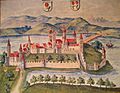
Rapperswil shown on the Codex Vindobonensis (1550).
-
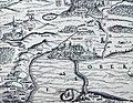
Upper Lake Zürich and Rapperswil on the Murerplan (1566).
-
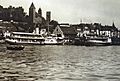
ZSG paddle steamships Stadt Rapperswil and Stadt Zürich at Rapperswil harbour (1914).
-
The wooden bridge, Heilig Hüsli chapel, and Rapperswil in the background.
-
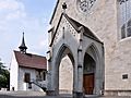
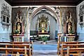
The portal of St. John's church and the Liebfrauenkapelle chapel.
-
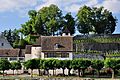
The Capuchin monastery seen from Lake Zürich.
-
Rose gardens near the Einsiedlerhaus.
-
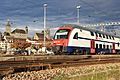
The S-Bahn Zürich S15 line at Rapperswil railway station, with Schloss Rapperswil and St. John's Church in the background.
-
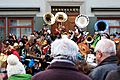
A Guggenmusik concert during the Eis-zwei-Geissebei festival.
-
Inside Knie's Kinderzoo.
-
Stadtmuseum Rapperswil
-
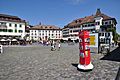
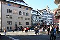
Fischmarktplatz
-
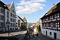
Engelplatz
-
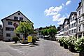
Herrenberg
-
Stadtmuseum Rapperswil, Liebfrauenkapelle, Stadtpfarrkirche St. Johann (St. John's church) and the Schloss, as seen from Kempraten-Lenggis
-
Liebfrauenkapelle (St Mary's church) between Schloss and Stadtpfarrkirche
-
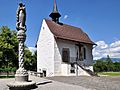
St. Ursula chappel (re-built in 1607)
-
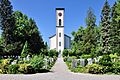
Reformierte Kirche (built in 1841)
-
Eis-zwei-Geissebei on the main square at Rathaus Rapperswil (townhall)
-
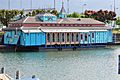
Herzbaracke cabaret-theater at Rapperswil harbour
-
See-Quai in Rapperswil, Bühlerallee to the left, Lindenhof hill in the background
-
Lindenhof and Deer park towards to the Schloss


_IMG_8578_ShiftN.jpg)


