Red Cones facts for kids
Quick facts for kids Red Cones |
|
|---|---|

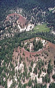
Close aerial view of the Red Cones toward the east-northeast. During eruption of both cones, lava poured through the breaches and spilled to the left.
|
|
| Highest point | |
| Elevation | 8,960 ft (2,730 m) |
| Geography | |
| Location | Madera County, California, United States |
| Geology | |
| Age of rock | 8500 years |
| Mountain type | Cinder cone |
| Last eruption | 5000 years ago |
The Red Cones are two special hills called cinder cones. They are located near Devils Postpile National Monument in central California. You can find them in Madera County, within the eastern Sierra Nevada mountains. They are also part of the Inyo National Forest.
What Are the Red Cones?
The Red Cones are a type of volcano known as a cinder cone. Imagine a giant pile of volcanic ash and rock bits. That's pretty much what a cinder cone is! They form when a volcano erupts, throwing out small pieces of lava that cool quickly in the air. These pieces, called cinders, then fall back down around the vent, building up a cone-shaped hill.
How the Red Cones Formed
The Red Cones last erupted about 5,000 years ago. During this eruption, two things happened. First, a lot of cinders exploded out, forming the two cone-shaped hills we see today. Second, hot, melted rock called basalt also flowed out. This lava flow came from the southern cone. It traveled about 1.5 kilometers (almost a mile) towards the Middle Fork of the San Joaquin River.
Part of a Bigger Volcanic Area
The Red Cones are at the southern end of a larger volcanic area. This area is called the Mono–Inyo Craters. Think of it as a chain of volcanoes and craters. The melted rock, or magma, that created the Red Cones came from the same source deep underground as the magma for the other Mono-Inyo craters. This means they are all connected to the same big volcanic system.

