Red Mountain (Costilla County, Colorado) facts for kids
Quick facts for kids Red Mountain |
|
|---|---|

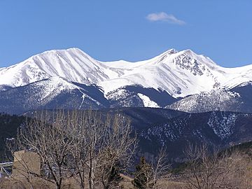
Red Mountain (left) and Culebra Peak (right)
|
|
| Highest point | |
| Elevation | 13,914 ft (4,241 m) |
| Prominence | 448 ft (137 m) |
| Isolation | 0.74 mi (1.19 km) |
| Geography | |
| Location | Costilla County, Colorado, U.S. |
| Parent range | Culebra Range |
| Topo map | USGS 7.5' topographic map Culebra Peak, Colorado |
| Climbing | |
| Easiest route | hike |
Red Mountain is a tall mountain peak located in south-central Colorado. It stands at an elevation of 13,914 ft (4,241 m), which is nearly 14,000 feet high! This makes it one of the many impressive summits in the Culebra Range. The mountain is about 15 mi (24 km) southeast of a town called San Luis.
About Red Mountain
Red Mountain is part of the beautiful Sangre de Cristo Mountains, a long mountain range that stretches through Colorado and New Mexico. The Culebra Range is a specific part of these mountains. Red Mountain is known for its height and its location in Costilla County.
Mountain Facts
- Elevation: Red Mountain reaches 13,914 feet (4,241 meters) above sea level. This is how high the top of the mountain is from the ocean.
- Location: The mountain is found in the state of Colorado, in the United States.
- Private Land: It's important to know that Red Mountain is on private land. This means you cannot visit or hike the mountain without getting special permission first.
Historical Names
Mountains often have different names over time. Red Mountain was also known by another name in the past.
- Espinazo Rojo: This was a name used for the mountain in 1972. "Espinazo Rojo" is Spanish for "Red Spine."
- Red Mountain: This name was also used starting in 1972 and is its current official name.
Black History Month on Kiddle
African-American Women in Medicine:
 | May Edward Chinn |
 | Rebecca Cole |
 | Alexa Canady |
 | Dorothy Lavinia Brown |

All content from Kiddle encyclopedia articles (including the article images and facts) can be freely used under Attribution-ShareAlike license, unless stated otherwise. Cite this article:
Red Mountain (Costilla County, Colorado) Facts for Kids. Kiddle Encyclopedia.

