Reeder Township, Michigan facts for kids
Quick facts for kids
Reeder Township, Michigan
|
|
|---|---|

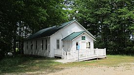
Reeder Township Hall
|
|

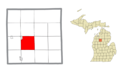
Location within Missaukee County and the state of Michigan
|
|
| Country | United States |
| State | Michigan |
| County | Missaukee |
| Area | |
| • Total | 34.91 sq mi (90.4 km2) |
| • Land | 34.78 sq mi (90.1 km2) |
| • Water | 0.13 sq mi (0.3 km2) |
| Elevation | 1,201 ft (366 m) |
| Population
(2020)
|
|
| • Total | 1,199 |
| • Density | 34.5/sq mi (13.3/km2) |
| Time zone | UTC-5 (Eastern (EST)) |
| • Summer (DST) | UTC-4 (EDT) |
| ZIP Code | |
| Area code(s) | 231 |
| FIPS code | 26-113-67840 |
| GNIS feature ID | 1626962 |
Reeder Township is a special kind of local government area called a civil township. It is located in Missaukee County in the state of Michigan, USA. In 2020, about 1,199 people lived in Reeder Township.
Contents
Places in Reeder Township
- The city of Lake City is found at the northwest corner of the township. It sits along the eastern shore of Lake Missaukee.
- Lake City was first known as "Reeder." This name came from Daniel Reeder. He built the very first log cabin near a lake then called Lake Muskrat.
- The post office in Lake City (ZIP code 49651) serves the northern two-thirds of Reeder Township.
- Frey was once a small community with its own post office. It was also a stop on the Grand Rapids and Indiana Railroad. The Frey post office was open from 1900 to 1903.
Geography of Reeder Township
Reeder Township covers an area of about 34.91 square miles (90.42 square kilometers). Most of this area, about 34.78 square miles (90.08 square kilometers), is land. The rest, about 0.12 square miles (0.31 square kilometers), is water.
The Clam River flows through the southern part of the township. This river is a branch of the larger Muskegon River.
Main Roads
- M-55 is a state highway that forms the northern border of Reeder Township.
- M-66 is another state highway. It runs along the western border of the township. Part of M-66 actually runs on the same road as M-55.
Population History
The number of people living in Reeder Township has changed over many years. Here is a look at how the population has grown and shrunk:
| Historical population | |||
|---|---|---|---|
| Census | Pop. | %± | |
| 1870 | 130 | — | |
| 1880 | 323 | 148.5% | |
| 1890 | 832 | 157.6% | |
| 1900 | 1,439 | 73.0% | |
| 1910 | 1,335 | −7.2% | |
| 1920 | 1,196 | −10.4% | |
| 1930 | 1,094 | −8.5% | |
| 1940 | 524 | −52.1% | |
| 1950 | 519 | −1.0% | |
| 1960 | 440 | −15.2% | |
| 1970 | 462 | 5.0% | |
| 1980 | 647 | 40.0% | |
| 1990 | 772 | 19.3% | |
| 2000 | 1,112 | 44.0% | |
| 2010 | 1,128 | 1.4% | |
| 2020 | 1,199 | 6.3% | |
| U.S. Decennial Census | |||
In the year 2000, there were 1,112 people living in Reeder Township. These people lived in 394 different homes. Most of the people were White, and a small number were Native American or Asian.
Many homes had children under 18 living there. Most families were married couples living together. The average age of people in the township was 34 years old.
See also
 In Spanish: Municipio de Reeder (Míchigan) para niños
 | Delilah Pierce |
 | Gordon Parks |
 | Augusta Savage |
 | Charles Ethan Porter |


