Reedy River facts for kids
Quick facts for kids Reedy River |
|
|---|---|

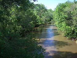
The Reedy River in Lake Conestee Nature Park
|
|
| Physical characteristics | |
| Main source | Greenville County, South Carolina 34°59′22″N 82°28′17″W / 34.98956°N 82.47151°W |
| River mouth | Saluda River 34°18′14″N 82°05′21″W / 34.30401°N 82.08928°W |
| Length | 65 mi (105 km) |
The Reedy River is a cool river in northwestern South Carolina, USA. It's about 65 miles (105 km) long. The Reedy River is a tributary, which means it's a smaller river that flows into a bigger one. It joins the Saluda River.
From the Saluda River, its water then flows into the Congaree River. All these rivers are part of a huge watershed that eventually leads to the Santee River. The Santee River then carries all this water out to the Atlantic Ocean! So, a drop of water from the Reedy River could end up in the ocean.
Contents
Where Does the Reedy River Flow?

The Reedy River starts in Greenville County. This area is in the foothills of the Blue Ridge Mountains. It begins about 10 miles (16 km) northwest of the city of Greenville.
The river then flows generally south-southeast. It goes right through the city of Greenville. After that, it passes through Lake Conestee Nature Park. It continues through the Piedmont region.
Finally, the Reedy River reaches Laurens County. Here, it joins the Saluda River. This meeting point is about 9 miles (14 km) northeast of Greenwood. Their waters become part of Lake Greenwood, which is a lake created by a dam on the Saluda River.
The Reedy River Falls: A Special Spot
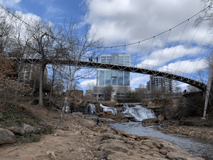
One of the most famous parts of the Reedy River is "The Falls." This is a large waterfall that flows through Falls Park in Greenville, South Carolina. It's a beautiful place to visit.
The amazing Liberty Bridge stretches over these falls. It offers a fantastic view of the waterfall and the park.
Keeping the Reedy River Clean
For a while, there were concerns about the water quality in the Reedy River. Sometimes, the water was not safe for people to swim in because of certain bacteria. There were signs to discourage people from playing in some parts of the river.
But good news! Many people are working hard to make the Reedy River cleaner. The city, volunteers, and even private companies are all helping. They teach people about clean water practices, like picking up after pets in the park.
There are also special programs that help people fix problems that could pollute the water. These efforts are making a big difference. They help keep the river healthy for everyone to enjoy.
How Do People Cross the Reedy River?
Many roads and bridges cross the Reedy River as it flows along. Here are some of the main crossings, starting from downtown Greenville:
Crossings in the City of Greenville
- US 123/S Academy Street
- River Street bridge
- Pedestrian bridge at the Peace Center (this used to be a railroad bridge!)
- Main Street bridge at Camperdown
- Liberty Bridge
- US 29/S Church Street
- McDaniel Avenue
- Woodland Way in Cleveland Park
- E Faris Road
- Cleveland Street
- S Pleasantburg Drive, SC 291
- Interstate 85
Crossings in Greenville County
- Mauldin Road
- Conestee Road
- Ashmore Bridge Road
- Interstate 185
- Log Shoals Road
- W Georgia Road
- New Harrison Bridge Road
- Jenkins Bridge Road and SC 418
- McKelvey Road in Fork Shoals
- McKittrick Bridge Road
- Hillside Church Road
- Dunklin Bridge Road
Crossings in Laurens County
- US 76 in Hickory Tavern
- SC 252
- Ekom Beach Road
- Indian Mound Road
- Riverfork Road over Lake Greenwood
 | Claudette Colvin |
 | Myrlie Evers-Williams |
 | Alberta Odell Jones |

