Renner, Indiana facts for kids
Quick facts for kids
Renner, Indiana
|
|
|---|---|

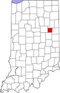
Blackford County's location in Indiana
|
|
| Country | United States |
| State | Indiana |
| County | Blackford |
| Township | Licking |
| Elevation | 919 ft (280 m) |
| Time zone | UTC-5 (Eastern (EST)) |
| • Summer (DST) | UTC-4 (EDT) |
| ZIP code |
47348
|
| Area code(s) | 765 |
| FIPS code | 18-63765 |
| GNIS feature ID | 441895 |
Renner is a ghost town in Indiana's Blackford County. An extinct village means it no longer has people living there. Even though the U.S. Geological Survey lists Renner as a "populated place," this is not true today.
Renner started as a stop on the Pittsburgh, Cincinnati and St. Louis Railroad. The land around this stop was first used to cut down trees for railroad crossties. Later, it became a large farm for raising animals. Homes for the farm workers' families were also built nearby.
It is believed that Renner was named after John W. Renner. He was an important leader for the Pittsburgh, Cincinnati and St. Louis Railroad. He also worked for the Pennsylvania Railroad for over 50 years. Another town, Rennerdale, Pennsylvania, was named after him in 1895.
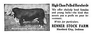
The farm next to the Renner railroad station was about 530 acres (2.1 km²). It was owned by Benjamin Johnson. In the early 1890s, it became known as the Renner Livestock Farm. This farm raised award-winning Hereford cattle, Hampshire hogs, and horses. One famous horse was "Poetry of Motion," a champion show horse.
Animals from the farm were shipped from the Renner station. The railroad stopped there up to four times a day. In the early 1900s, the Renner station was one of the most important railroad stops in Blackford County.
In 1919, Benjamin Johnson sold all the farm's animals. Then he sold the farm itself. Fred A. Stimson bought the farm. He continued the farm's tradition of raising award-winning animals. In 1927, Stimson sold the cattle. After that, the farm was used for general crops. In 1937, the Scripps Foundation bought the farm. This was connected to Miami University in Oxford, Ohio.
Contents
History of Renner
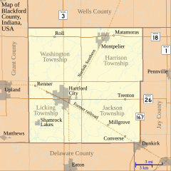
The Renner railroad stop was in Blackford County's Licking Township. It was located northwest of Hartford City. The nearby Renner Stock Farm used this station to ship its animals around the world.
The railroad line came to Blackford County in 1867. However, the Renner Stock Farm did not start until the early 1890s. The Renner Stock Farm is famous for creating a type of beef cattle called the Bullion 4th. This was a special kind of Polled Hereford.
The Railroad Line
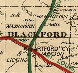
The railroad line through Renner was called the Union and Logansport Railroad Company. It entered Blackford County in 1867. This was the first railroad in the county. The idea for this line came about in 1862. It was finished to Hartford City in 1867.
The railroad passed through several Blackford County towns. These included Dunkirk, Converse, Millgrove, Hartford City, and Renner. Over time, the railroad changed names many times. Some of its names included the Pittsburgh, Cincinnati and St. Louis Railroad, the Panhandle division of the Pennsylvania Railroad, Penn Central Transportation Company, Conrail, and Norfolk Southern Railway. Today, the line is no longer used east of Hartford City. But it is still active west of the city, going through Renner to Upland, Indiana.
Geography of Renner
Renner is located in East Central Indiana. It is northwest of Hartford City. Millions of years ago, two glaciers flattened the northern part of Indiana. This includes the area where Licking Township and Renner are. These glaciers also created the rich farmland found in Blackford County.
The region is still mostly used for agriculture. Soybeans and corn are the most common crops grown in Blackford County. More than 65,000 acres (263 km²) are used for these two crops. Other crops and animals are also raised in the county. A farm still exists in the Renner area today. You can see it from satellite images. However, the old railroad station is no longer there.
Nearby Roads
Nearby Towns and Cities
- Upland is about 4 highway miles (6.4 km) west.
- Hartford City is about 5 highway miles (8 km) southeast.
- Gas City is about 10 highway miles (16 km) west.
- Marion is about 18 highway miles (29 km) northwest.
- Muncie is about 26 highway miles (42 km) southeast.
 | William Lucy |
 | Charles Hayes |
 | Cleveland Robinson |


