Richmond Heights, Florida facts for kids
Quick facts for kids
Richmond Heights, Florida
|
|
|---|---|

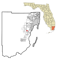
Location in Miami-Dade County and the state of Florida
|
|

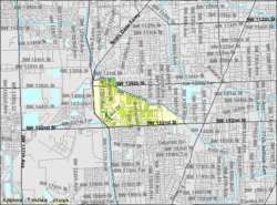
U.S. Census Bureau map showing CDP boundaries
|
|
| Country | |
| State | |
| County | |
| Area | |
| • Total | 1.61 sq mi (4.17 km2) |
| • Land | 1.59 sq mi (4.13 km2) |
| • Water | 0.01 sq mi (0.04 km2) |
| Elevation | 10 ft (3 m) |
| Population
(2020)
|
|
| • Total | 8,944 |
| • Density | 5,611.04/sq mi (2,166.62/km2) |
| Time zone | UTC-5 (Eastern (EST)) |
| • Summer (DST) | UTC-4 (EDT) |
| ZIP codes |
33157, 33176, 33186 (Miami)
|
| Area code(s) | 305, 786, 645 |
| FIPS code | 12-60225 |
| GNIS feature ID | 0289685 |
Richmond Heights is a community in Miami-Dade County, Florida, in the United States. It's a special kind of area called a census-designated place (CDP). This means it's a place recognized by the government for counting people, but it doesn't have its own city government. Richmond Heights is part of the larger Miami metropolitan area in South Florida. In 2020, about 8,944 people lived there.
Contents
History of Richmond Heights
From Airship Base to Community
The story of Richmond Heights began during World War II. The United States Navy bought a large piece of land in what is now Miami-Dade County. They wanted to build a base for airships, which are like large blimps. This land belonged to the Richmond Timber Company. So, the base was named Naval Air Station Richmond.
This airship base was very important. It was the second largest airship base in the United States. About 25 airships were stationed there. These airships helped protect ships from enemy submarines in the Florida Straits. Sadly, the base was destroyed by a hurricane and a fire in 1945.
A New Home for Veterans
After World War II ended, a pilot named Captain Frank C. Martin bought land next to the old airship base. He wanted to create a new community. His goal was to build a place for African American veterans returning from the war. This new community became Richmond Heights.
The land Captain Martin bought was once part of the large area used for the airship base. The base had three huge hangars, which were like giant garages for the blimps. These hangars were as tall as 16-story buildings!
Geography of Richmond Heights
Richmond Heights is located about 16 miles southwest of downtown Miami. It sits at coordinates 25°38′0″N 80°22′21″W. The community is surrounded by other areas. To the north and east is Kendall. To the south is Palmetto Estates. And to the west, you'll find Three Lakes.
The United States Census Bureau says that Richmond Heights covers about 1.6 square miles of land. A very small part of this area, about 0.02 square miles, is water.
Population and People
How Many People Live Here?
The population of Richmond Heights has changed over the years. Here's how many people have lived there during different census counts:
| Historical population | |||
|---|---|---|---|
| Census | Pop. | %± | |
| 1960 | 4,311 | — | |
| 1970 | 6,663 | 54.6% | |
| 1980 | 8,577 | 28.7% | |
| 1990 | 8,583 | 0.1% | |
| 2000 | 8,479 | −1.2% | |
| 2010 | 8,541 | 0.7% | |
| 2020 | 8,944 | 4.7% | |
| U.S. Decennial Census | |||
In 2020, the 2020 United States census counted 8,944 people living in Richmond Heights. There were 2,635 households and 2,133 families. In 2010, there were 8,541 people, 2,566 households, and 2,058 families.
Things to Do and See
Community Events
Each year, many people come back to Miami-Dade County for the Historic Weekend. This event is hosted by the Historic Society. It's a time to celebrate the history of the area.
The Richmond Heights 49ers is a group that has received support from different organizations. These include the Florida Humanities Council and the Miami-Dade County Cultural Arts Department.
See also
 In Spanish: Richmond Heights para niños
 | Toni Morrison |
 | Barack Obama |
 | Martin Luther King Jr. |
 | Ralph Bunche |

