
Ridgeway Hill facts for kids
Quick facts for kids Ridgeway Hill |
|
|---|---|

Ridgeway Hill (right) on the Purbeck Ridge, Dorset, seen from Povington Hill to the west
|
|
| Highest point | |
| Elevation | 199 m (653 ft) |
| Prominence | 107 m (351 ft) |
| Parent peak | Swyre Head |
| Listing | HuMP |
| Geography | |
| Location | Dorset, England |
| Parent range | Purbeck Hills |
| OS grid | SY914817 |
| Topo map | OS Landranger 195 Explorer 15E |
Ridgeway Hill is a cool spot in Dorset, England. People sometimes call it Grange Hill or Steeple Hill. It's part of the Purbeck Hills and stands at 199 meters (about 653 feet) tall. This makes it the third highest point in the Purbeck Hills. It's also one of the few hills in Dorset that are considered a "HuMP," which means it sticks up more than 100 meters from the land around it.
Near the top of Ridgeway Hill, you can find an old building called Grange Arch. This arch was built way back in the 1700s by Denis Bond, who owned a nearby estate called Creech Grange. It's known as a folly, which is a building made just for decoration, not for living in or for a specific purpose. On the eastern side of the hill, there's a special area called Stonehill Down. This place is now a nature reserve, which means it's protected for its wildlife and plants. From Ridgeway Hill, you can also get great views of Swyre Head, which is part of the famous Jurassic Coast.
Exploring Ridgeway Hill's Location
Ridgeway Hill is located in a really interesting part of Dorset. It's about 2.8 kilometers (1¾ miles) from Kimmeridge Bay, which is a beautiful spot on Dorset's Jurassic Coast. The hill is also about 4.5 kilometers (2.8 miles) west of the historic Corfe Castle.
At the southern base of Ridgeway Hill, you'll find the small village of Steeple. To the west of Ridgeway Hill is Povington Hill. Povington Hill is well-known, but it's a little bit shorter than Ridgeway Hill. Near Povington Hill, you can also see the abandoned village of Tyneham. The Lulworth Ranges, which are used for military training, are located between Ridgeway Hill and the coast.
Finding Your Way to Ridgeway Hill
If you want to visit Ridgeway Hill, there's a free car park called Steeple Hill Car Park. It's located on the ridge, just west of the very top of the hill, off the Grange Hill road. From this car park, you can enjoy amazing views of the whole area around you. It's a great spot to start a walk and explore the Purbeck Hills.
Gallery
-
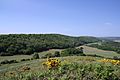
The long wooded back of Ridgeway Hill seen from Creech Barrow Hill to the North East
-
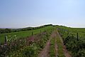
The footpath up the western slope of Ridgeway Hill from the car park


