
Swyre Head facts for kids
Quick facts for kids Swyre Head |
|
|---|---|

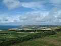
Swyre Head, seen from the SW Coast Path on the W side of St Aldhelm's Head
|
|
| Highest point | |
| Elevation | 208 m (682 ft) |
| Prominence | 150 m (490 ft) |
| Parent peak | Lewesdon Hill |
| Listing | Marilyn |
| Geography | |
| Location | Purbeck Hills, England |
| OS grid | SY934784 |
| Topo map | OS Landranger 195 Explorer 15E |
Swyre Head is the highest point in the Purbeck Hills and on the Isle of Purbeck. It's located in Dorset, on the south coast of England. This hill is about 2 kilometers (1.2 miles) southwest of the village of Kingston. It's also about 5 kilometers (3.1 miles) south of Corfe Castle and 8 kilometers (5 miles) west of Swanage.
Contents
What is Swyre Head?
Swyre Head might not be super tall, but it's special because of its relative height. This means it stands out a lot from the land around it. Because of this, it almost qualifies as a Marilyn. A Marilyn is a hill in the British Isles that is at least 150 meters (492 feet) higher than the land around its base.
This hill is made of chalk. It's part of a huge area of chalk hills called the Southern England Chalk Formation.
Don't Get Confused!
There's another hill in Dorset also called Swyre Head. This other hill is much smaller, only 98 meters (322 feet) high. It's located near the coast, west of a famous landmark called Durdle Door.
The two Swyre Heads are quite far apart. It would take about four hours to walk from one to the other, which is about 18 kilometers (11 miles). The Swyre Head we are talking about here is the one near Kingston.
Amazing Views from the Top
From the top of Swyre Head, you can see for miles!
- To the west, you can see past the Isle of Portland all the way to Dartmoor.
- To the east, you might spot the Isle of Wight.
- Looking north, you can see across the Purbeck Hills to Poole Harbour. You can also see another Purbeck Marilyn called Nine Barrow Down.
- If you look to the west, you might even see the old tower called Clavell Tower.
Getting to Swyre Head
Swyre Head is not directly on the South West Coast Path, which is a long walking trail. However, it's easy to reach the hill from nearby villages. You can start your walk from Kingston or Kimmeridge.
The highest point of the hill is 208 meters (682 feet) above sea level. There's a special marker called a trig point on the hill, which is used by mapmakers. This trig point is marked as 203 meters on Ordnance Survey maps. However, the very highest spot is actually a tumulus. A tumulus is an ancient burial mound, which is now completely covered in grass.
Gallery
-
View west from the summit of Swyre Head
-
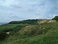
Swyre Head from the north-east


