Nine Barrow Down facts for kids
Quick facts for kids Nine Barrow Down |
|
|---|---|

Nine Barrow Down from the north of Swyre Head
|
|
| Highest point | |
| Elevation | 199 m (653 ft) |
| Prominence | c. 152 metres (499 ft) |
| Parent peak | Lewesdon Hill |
| Listing | Marilyn |
| Geography | |
| Location | Purbeck Hills, England |
| OS grid | SZ008811 |
| Topo map | OS Landranger 195 Explorer 15E |
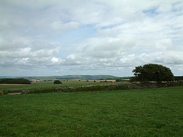
Nine Barrow Down is a long, gentle hill in Dorset, England. It's part of the Purbeck Hills, which are on a special area called the Isle of Purbeck. This hill is made of chalk, a soft white rock. It's known for its amazing views and ancient burial mounds.
The eastern part of the hill is the highest point. Sometimes, this area is also called Godlingston Hill. Nine Barrow Down is considered a "Marilyn" because it's tall enough and stands out from the land around it. A Marilyn is a hill in the British Isles that is at least 150 metres (about 492 feet) high.
Contents
Exploring Nine Barrow Down
Nine Barrow Down is a cool place to explore! It's a long, gentle hill that stretches across the northern part of the Isle of Purbeck in Dorset, England. The hill is made of chalk, which is a type of soft, white rock. This chalk forms part of a much larger area of chalk hills across southern England.
What You Can See
From the top of Nine Barrow Down, you can see some amazing sights! To the north, you can look across Poole Harbour. On a clear day, you might even spot the Spinnaker Tower in Portsmouth, which is quite far away!
If you look south, you'll see the other ridge of the Purbeck Hills, including a hill called Swyre Head. To the southeast, you can see the town of Swanage and its beautiful bay. It's a great spot for taking photos!
Ancient Burial Mounds
The hill gets its name from the nine ancient burial mounds found along its ridge. These mounds are called barrows or tumuli (plural of tumulus). They are very old, dating back to the Stone Age. People built these mounds to bury important people from their communities long, long ago.
The Missing Trig Point
For a long time, there was a special marker on the hill called a trig point. Trig points are concrete pillars used by mapmakers, like the Ordnance Survey, to help create accurate maps of the land.
However, the farmer who owns the land recently removed this trig point. He had permission from the Ordnance Survey to do so. You can still see the trig point and its concrete base lying on its side, just south of a public path called a bridleway. The very highest point of the hill is in a field that is not open to the public.
Nature and Radio Signals
Most of Nine Barrow Down is covered in a type of grass called calcareous grassland. This kind of grassland grows on chalky soil. Animals like cattle, sheep, and rabbits often graze here, helping to keep the grass short. Only a small part of the land is used for growing crops.
The hill is also home to a radio transmitter. This transmitter sends out signals for Heart South Coast on 102.3 FM and for NOW Digital Multiplexes. So, while you're enjoying the views, radio waves are busy traveling through the air!
 | Stephanie Wilson |
 | Charles Bolden |
 | Ronald McNair |
 | Frederick D. Gregory |

