Rikuzentakata, Iwate facts for kids
Quick facts for kids
Rikuzentakata
陸前高田市
|
|||||||||||||
|---|---|---|---|---|---|---|---|---|---|---|---|---|---|
|
City
|
|||||||||||||

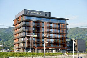
New Rikuzentakata City Hall
|
|||||||||||||
|
|||||||||||||

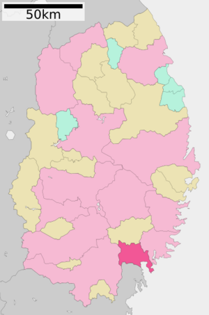
Location of Rikuzentakata in Iwate Prefecture
|
|||||||||||||
| Country | Japan | ||||||||||||
| Region | Tōhoku | ||||||||||||
| Prefecture | Iwate | ||||||||||||
| Area | |||||||||||||
| • Total | 231.94 km2 (89.55 sq mi) | ||||||||||||
| Population
(October 10, 2020)
|
|||||||||||||
| • Total | 18,262 | ||||||||||||
| • Density | 78.736/km2 (203.925/sq mi) | ||||||||||||
| Time zone | UTC+9 (Japan Standard Time) | ||||||||||||
| Phone number | 0192-54-2111 | ||||||||||||
| Climate | Cfa | ||||||||||||
|
|||||||||||||
Rikuzentakata (陸前高田市 (Rikuzentakata-shi)) is a city in Iwate Prefecture, Japan. It is located in the northeastern part of Japan. In 2010, the city had about 23,302 people. However, the city was greatly damaged by the 2011 Tōhoku earthquake and tsunami. As of March 2020, the population was estimated to be around 19,062 people. The city covers an area of about 231.94 square kilometers (89.55 sq mi).
Contents
Geography of Rikuzentakata
Rikuzentakata is in the very southeast corner of Iwate Prefecture. It is next to the Pacific Ocean on its eastern side. The city used to have a lake called Lake Furukawanuma, but it was destroyed by the 2011 tsunami. Some parts of the city's coast are inside the Sanriku Fukkō National Park. This park helps protect the beautiful natural areas.
Nearby Cities and Towns
Rikuzentakata shares its borders with several other places:
- In Iwate Prefecture:
- Ichinoseki
- Ōfunato
- Sumita
- In Miyagi Prefecture:
Climate in Rikuzentakata
Rikuzentakata has a humid subtropical climate. This means it has warm summers and cold winters. The average temperature each year is about 11.1°C (52.0°F). The city gets about 1343 mm (53 inches) of rain every year. September is usually the wettest month, and January is the driest. Temperatures are highest in August, around 23.7°C (74.7°F), and lowest in January, around 0.0°C (32.0°F).
| Climate data for Rikuzentakata (2011−2020 normals, extremes 2011−present) | |||||||||||||
|---|---|---|---|---|---|---|---|---|---|---|---|---|---|
| Month | Jan | Feb | Mar | Apr | May | Jun | Jul | Aug | Sep | Oct | Nov | Dec | Year |
| Record high °C (°F) | 12.8 (55.0) |
17.6 (63.7) |
23.5 (74.3) |
29.4 (84.9) |
34.4 (93.9) |
32.8 (91.0) |
36.8 (98.2) |
36.0 (96.8) |
32.2 (90.0) |
28.0 (82.4) |
21.4 (70.5) |
18.5 (65.3) |
36.8 (98.2) |
| Mean daily maximum °C (°F) | 4.2 (39.6) |
5.2 (41.4) |
9.9 (49.8) |
14.6 (58.3) |
20.1 (68.2) |
22.4 (72.3) |
25.9 (78.6) |
27.9 (82.2) |
24.9 (76.8) |
19.2 (66.6) |
13.2 (55.8) |
6.7 (44.1) |
16.2 (61.1) |
| Daily mean °C (°F) | 0.4 (32.7) |
0.8 (33.4) |
4.7 (40.5) |
9.3 (48.7) |
14.8 (58.6) |
18.0 (64.4) |
21.9 (71.4) |
23.7 (74.7) |
20.3 (68.5) |
14.2 (57.6) |
8.1 (46.6) |
2.6 (36.7) |
11.6 (52.8) |
| Mean daily minimum °C (°F) | −3.0 (26.6) |
−3.0 (26.6) |
0.1 (32.2) |
4.4 (39.9) |
10.2 (50.4) |
14.5 (58.1) |
19.0 (66.2) |
20.6 (69.1) |
16.7 (62.1) |
9.8 (49.6) |
3.7 (38.7) |
−0.9 (30.4) |
7.7 (45.8) |
| Record low °C (°F) | −10.6 (12.9) |
−11.0 (12.2) |
−5.6 (21.9) |
−3.0 (26.6) |
0.7 (33.3) |
7.2 (45.0) |
14.3 (57.7) |
12.7 (54.9) |
7.4 (45.3) |
1.5 (34.7) |
−3.2 (26.2) |
−6.2 (20.8) |
−11.0 (12.2) |
| Average precipitation mm (inches) | 33.3 (1.31) |
34.3 (1.35) |
98.2 (3.87) |
123.7 (4.87) |
113.3 (4.46) |
137.9 (5.43) |
170.5 (6.71) |
167.1 (6.58) |
180.3 (7.10) |
161.0 (6.34) |
69.1 (2.72) |
51.5 (2.03) |
1,350.9 (53.19) |
| Average precipitation days (≥ 1.0 mm) | 4.8 | 5.4 | 7.0 | 8.3 | 9.2 | 10.2 | 12.6 | 12.6 | 11.1 | 8.7 | 6.4 | 6.6 | 102.9 |
| Source: JMA | |||||||||||||
Population Changes
The number of people living in Rikuzentakata grew until the 1950s. Since then, the population has slowly gone down over the last 70 years.
| Historical population | ||
|---|---|---|
| Year | Pop. | ±% |
| 1920 | 20,773 | — |
| 1930 | 24,494 | +17.9% |
| 1940 | 26,222 | +7.1% |
| 1950 | 32,609 | +24.4% |
| 1960 | 31,839 | −2.4% |
| 1970 | 30,308 | −4.8% |
| 1980 | 29,356 | −3.1% |
| 1990 | 27,242 | −7.2% |
| 2000 | 25,676 | −5.7% |
| 2010 | 23,302 | −9.2% |
| 2020 | 18,262 | −21.6% |
History of Rikuzentakata
The area where Rikuzentakata is today has a very long history. People have lived here since at least the Jōmon period, which was thousands of years ago. The Emishi people lived here before the area came under the control of the Japanese imperial family during the early Heian period.
Later, during the Sengoku period (a time of many wars), different samurai families ruled the area. Eventually, the Date clan took control during the Edo period. They ruled the Sendai Domain under the Tokugawa shogunate.
The towns of Kesen and Takata were officially created in 1889. The area suffered from big tsunamis in 1896 and 1933. On January 1, 1955, Kesen and Takata joined with other nearby towns and villages to form the city of Rikuzentakata.
The 2011 Tōhoku Earthquake and Tsunami
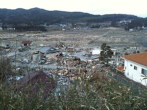
Rikuzentakata was almost completely destroyed by the huge tsunami that followed the Tōhoku earthquake in March 2011. The tsunami was incredibly powerful. It flooded every building shorter than three stories high. Even taller buildings, like the city hall, were partly flooded, with water reaching the third floor.
The city had prepared for tsunamis and had a seawall about 6.5 meters (21 feet) high. However, the 2011 tsunami created a wave that was about 13 meters (43 feet) high. This was much taller than expected and overwhelmed the defenses. More than 80% of the city's 8,000 homes were washed away. Many people, including firefighters trying to close harbor gates, were tragically lost.
Sadly, over 1,600 people from the city died, and hundreds more were missing and presumed dead. The city's museum lost its collections and all six staff members. The mayor, Futoshi Toba, survived at city hall, but his wife was lost at their home by the sea.
Rebuilding the City
After the disaster, a huge project began to rebuild Rikuzentakata. To protect against future tsunamis, the city center was raised by more than 10 meters (33 feet) using rock fill. A massive conveyor belt system, called the "Bridge of Hope," was built to carry rocks from a hill across the Kesen River to the city center.
Today, a new marketplace and community center have been built on this raised land. Work is still happening to create new streets and bridges. The area where the rocks were quarried is also being developed into a new neighborhood.
Economy
The main ways people in Rikuzentakata make a living are through commercial fishing and processing food. For example, in 2011, oyster farming brought in about ¥40 million (around $300,000 USD) in sales for the city each year.
Education
Rikuzentakata has several schools for children and teenagers:
- Eight public elementary schools
- Two public junior high schools
- One public high school, run by the Iwate Prefectural Board of Education
- One private high school
Transportation
Railway
![]() East Japan Railway Company (JR East) - Ōfunato Line
East Japan Railway Company (JR East) - Ōfunato Line
- The train services on this line were stopped after the tsunami. Now, a BRT (Bus Rapid Transit) system runs instead.
- Rikuzen-Yahagi - Takekoma - Rikuzen-Takata - Wakinosawa - Otomo
Highways
 Sanriku Expressway
 National Route 45
 National Route 340
 National Route 343
Local Attractions
Takata-matsubara and the Miracle Pine
Takata-matsubara (error: {{nihongo}}: Japanese or romaji text required (help)) was a famous two-kilometer (1.2-mile) long beach. It was once lined with about seventy thousand pine trees. It was so beautiful that it was chosen as one of the "100 Landscapes of Japan" in 1927.
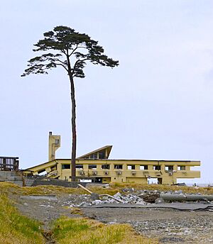
After the 2011 tsunami, almost all the trees were washed away. Only one, a ten-meter (33-foot) tall, two-hundred-year-old pine tree, remained standing. This tree became known as the "Miracle Pine." It was a symbol of hope and resilience for the city.
However, the land sank, and the tree was too close to the sea. The saltwater eventually poisoned it, and it died. In 2012, the tree was cut down to be preserved. In 2013, an artificial "commemorative tree" was put in its place to remember the original forest and the disaster.
Famous People from Rikuzentakata
- Naoya Hatakeyama, a photographer
- Toru Kikawada, a politician
- Hiroaki Murakami, an actor
- Rōki Sasaki, a baseball player
Sister Cities
Rikuzentakata has a sister city relationship with:
 Crescent City, United States (since 2018)
See also
 In Spanish: Rikuzentakata para niños
 | Aaron Henry |
 | T. R. M. Howard |
 | Jesse Jackson |


