Ripley, Oklahoma facts for kids
Quick facts for kids
Ripley, Oklahoma
|
|
|---|---|

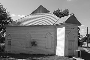
Old church in Ripley (2013)
|
|

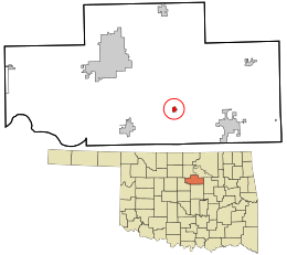
Location within Payne County and Oklahoma
|
|
| Country | United States |
| State | Oklahoma |
| County | Payne |
| Area | |
| • Total | 0.47 sq mi (1.23 km2) |
| • Land | 0.47 sq mi (1.23 km2) |
| • Water | 0.00 sq mi (0.00 km2) |
| Elevation | 856 ft (261 m) |
| Population
(2020)
|
|
| • Total | 346 |
| • Density | 729.96/sq mi (282.01/km2) |
| Time zone | UTC-6 (Central (CST)) |
| • Summer (DST) | UTC-5 (CDT) |
| ZIP code |
74062
|
| Area code(s) | 539/918 |
| FIPS code | 40-63500 |
| GNIS feature ID | 2412554 |
Ripley is a small town in southeastern Payne County, Oklahoma, in the United States. In 2020, about 346 people lived there. The town was named after Edward Ripley. He was the 14th president of the Atchison, Topeka and Santa Fe Railway.
Contents
History of Ripley
The Atchison, Topeka and Santa Fe Railway, often called the Santa Fe, helped create Ripley. They sold the first land lots on January 13, 1900. Just three months later, a local newspaper said the town already had 1,000 people.
On July 31, 1900, the first wagon bridge across the Cimarron River was finished. This was a big event, and people celebrated with a large party.
Economy and Growth
Farming was the main way people made money, along with the railroad. A large farm called Morehead Plantation hired many African-American workers to grow cotton. After World War I, the cotton business slowed down a lot.
However, oil was discovered in the county, which helped the town's economy for a while. But in the late 1920s, oil prices dropped. The start of the Great Depression also made the town's economy worse.
Ripley's population went down from 487 people in 1930 to 292 in 1950. It dropped even more to 263 in 1960. The population grew back to 451 in 1980 and 376 in 1990. It reached 510 people in 2009, but by 2016, it was back down to 403.
Geography of Ripley
Ripley covers about 0.4 square miles (1.2 square kilometers) of land. There is no water area within the town limits.
The town is located near the Cimarron River. It is southeast of Stillwater. To get there, you go about 8 miles (13 km) east on State Highway 51. Then you go 7 miles (11 km) south on State Highway 108.
Cushing Lake is just southeast of Ripley. This lake is a great spot for outdoor fun. It has a boat ramp, a dock, and a picnic area.
Population Information
| Historical population | |||
|---|---|---|---|
| Census | Pop. | %± | |
| 1900 | 474 | — | |
| 1910 | 368 | −22.4% | |
| 1920 | 406 | 10.3% | |
| 1930 | 487 | 20.0% | |
| 1940 | 415 | −14.8% | |
| 1950 | 292 | −29.6% | |
| 1960 | 263 | −9.9% | |
| 1970 | 307 | 16.7% | |
| 1980 | 451 | 46.9% | |
| 1990 | 376 | −16.6% | |
| 2000 | 444 | 18.1% | |
| 2010 | 403 | −9.2% | |
| 2020 | 346 | −14.1% | |
| U.S. Decennial Census | |||
In the year 2000, Ripley had 444 people living in 158 households. About 118 of these were families. The population density was about 1,190 people per square mile (459 people per square kilometer).
Most people in Ripley were White (about 89.6%). About 5% were Native American. A small number (1.35%) were Hispanic or Latino.
Many households (40.5%) had children under 18 living with them. About 51.3% were married couples. The average household had 2.81 people, and the average family had 3.21 people.
The population was spread out by age. About 32.9% were under 18 years old. About 11.9% were 65 years or older. The average age in the town was 32 years.
Famous People from Ripley
- William A. Berry (1915–2004) - He was born in Ripley and became a judge on the Oklahoma Supreme Court.
- Billy McGinty (1871–1961) - He was a cowboy and a member of the Roosevelt Rough Riders Association. He also had a band called McGinty's Cowboy Band.
- Casey Sadler (1990-) - He is a professional baseball pitcher who plays in MLB for the Seattle Mariners.
Local Landmarks
- Allen Williamson Bridge - This is a special bridge near Ripley. It is named after Allen Williamson, who was a representative for Oklahoma.
- The Hopkins Sandstone House and Farmstead - This historic place is listed on the National Register of Historic Places listings in Payne County, Oklahoma. It is an important part of the area's history.
See also
 In Spanish: Ripley (Oklahoma) para niños
 | Emma Amos |
 | Edward Mitchell Bannister |
 | Larry D. Alexander |
 | Ernie Barnes |

