Riva, Maryland facts for kids
Quick facts for kids
Riva, Maryland
|
|
|---|---|

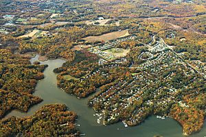
Aerial view of Riva.
|
|

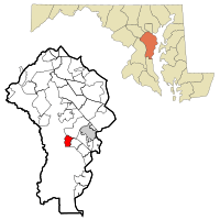
Location of Riva, Maryland
|
|
| Country | |
| State | |
| County | |
| Area | |
| • Total | 2.90 sq mi (7.52 km2) |
| • Land | 2.46 sq mi (6.36 km2) |
| • Water | 0.45 sq mi (1.16 km2) |
| Elevation | 43 ft (13 m) |
| Population
(2020)
|
|
| • Total | 4,257 |
| • Density | 1,732.60/sq mi (669.08/km2) |
| Time zone | UTC−5 (Eastern (EST)) |
| • Summer (DST) | UTC−4 (EDT) |
| ZIP code |
21140
|
| Area code(s) | 410, 443, and 667 |
| FIPS code | 24-66400 |
| GNIS feature ID | 0591136 |
Riva is a special kind of community in Anne Arundel County, Maryland, United States. It's called a census-designated place (CDP), which means it's an area that the government counts for population, but it doesn't have its own city government.
In 2020, about 4,257 people lived in Riva. The area is very pretty, especially where Riva Road crosses the South River on a bridge. Riva is growing with many new homes as the nearby city of Annapolis expands. Riva is next to Annapolis to the north, Edgewater to the east, and Davidsonville to the west.
Students in Riva attend Central Elementary School, Davidsonville Elementary School, Central Middle School, and South River High School in Edgewater, Maryland.
Contents
History of Riva
Riva has a rich past, with some areas holding historical importance.
Early History and Archeological Sites
The Aisquith Farm E Archeological Site is a special place in Riva. It was added to the National Register of Historic Places in 1991. This means it's an important historical site that helps us learn about the past.
How Riva Grew: New Communities
Over the years, Riva has seen several large neighborhoods built. These developments helped the area grow and become what it is today. Some of these communities include:
- Sylvan Shores
- Riva Farms
- Berkshire (built between 1978 and 1981)
- Annapolis Landing (started in 1979)
Where is Riva Located?
Riva is located at 38°57′7″N 76°34′56″W / 38.95194°N 76.58222°W. This is its exact spot on a map.
Size and Water Areas
According to the United States Census Bureau, Riva covers a total area of about 7.5 square kilometers (2.9 square miles). Most of this area, about 6.4 square kilometers (2.46 square miles), is land. The rest, about 1.2 square kilometers (0.45 square miles), is water. This means about 15% of Riva is covered by water.
People of Riva
The number of people living in Riva has changed over time.
Population Growth
| Historical population | |||
|---|---|---|---|
| Census | Pop. | %± | |
| 2000 | 3,966 | — | |
| 2010 | 4,076 | 2.8% | |
| 2020 | 4,257 | 4.4% | |
| 2022 (est.) | 4,784 | 17.4% | |
| Sources: 2000-2020 | |||
In 2000, there were 3,966 people living in Riva. By 2020, the population had grown to 4,257. This shows that more people are choosing to live in Riva.
Who Lives in Riva?
In 2000, there were 1,423 households in Riva. A household is a group of people living together in one home. Most households, about 72%, were married couples living together. About 37.6% of households had children under 18.
The average age of people in Riva in 2000 was 39 years old. About 26% of the population was under 18, and about 7.9% were 65 or older.
Income in Riva
In 2000, the average income for a household in Riva was about $88,287 per year. For families, the average income was about $95,457. These numbers show that Riva is a community with a good economic standing.
Famous People from Riva
- Peter Bondra: He is a former professional ice hockey player who played in the NHL. He also used to be the general manager for the Slovakia men's national ice hockey team.
See also
 In Spanish: Riva (Maryland) para niños
 | Leon Lynch |
 | Milton P. Webster |
 | Ferdinand Smith |

