River Burn, North Yorkshire facts for kids
Quick facts for kids River Burn |
|
|---|---|

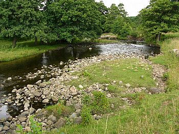
River Burn near Masham
|
|
|
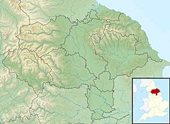
Location of river mouth
|
|
| Other name(s) | Bourne Burne (archaic) |
| United Kingdom | England |
| County | North Yorkshire |
| Physical characteristics | |
| Main source | Little Haw 1,509 feet (460 m) 54°12′08.4″N 1°51′36.1″W / 54.202333°N 1.860028°W |
| River mouth | River Ure Masham 230 feet (70 m) 54°12′46.9″N 1°38′51.4″W / 54.213028°N 1.647611°W |
| Length | 12 miles (19 km) |
| Basin features | |
| River system | River Ure |
| Basin size | 27 square miles (69.5 km2) |
| Tributaries |
|
| Waterfalls | High House Farm |
The River Burn is a river found entirely within North Yorkshire, England. It begins as several small streams on Masham Moor. The river then flows through an area called Colsterdale, moving eastwards. Finally, it empties into the River Ure just south of Masham. In 2016, a special project removed a small dam (weir) and helped fish get into the river. Because of this, salmon have been seen laying their eggs (spawning) in the river. This is the first time in over 100 years!
Even though the River Burn valley is not in Nidderdale, most of it is part of the Nidderdale Area of Outstanding Natural Beauty. This means it is a special place with beautiful scenery.
Contents
River Burn History
How the River Burn Formed
Long ago, during the Ice Age, huge sheets of ice called glaciers moved across the land. A glacier pushed water into what are now the valleys of Pott Beck and the River Burn. This created big lakes. These lakes left behind minerals like limestone and chert. The river flows over different types of rock. These include limestone, sandstone, mudstone, and shale. The rocks are covered by gravel and silty clay. This material is called alluvia, which is left by rivers. Tests in the 1990s showed this alluvia was very large and rough. It was the biggest sediment flowing out of the Humber basin.
The Name of the River
The name of the river, Burn, comes from an old English word, Burna. This word simply means a small stream or brook. Over time, the name has been written in different ways. These include Bourne, Burne, or Burn. It's interesting that the river's name doesn't also name its valley. Most other valleys in the Yorkshire Dales are named after their rivers. The valley is called Colsterdale. It got this name in the 12th century. This was because coal was mined in the upper parts of the valley. The coal was carried down a path called The Coal Road, which you can still see today. Sometimes, people do call the valley the Burn Valley or the River Burn Valley.
Past Projects on the River
Around the early 1900s, people wanted to build reservoirs on the River Burn. These were planned by the Leeds Corporation. Work started on a reservoir in 1904 at Gollinglith Foot. But it had to stop in 1906 because of landslips. Landslips happen when a lot of earth slides down a slope.
In 2016, a project costing £20,000 removed a weir at Breary Banks. A weir is a small dam that can block fish. In 2017, it was reported that salmon had successfully passed this area. They laid their eggs there for the first time in over 100 years. This project was partly paid for by ABP. It was part of a bigger plan called the Green Port Hull Project. This project helps fish that migrate through the Humber Basin.
To help even more, the Ure Salmon Trust released over 30,000 young salmon, called smolts, into the river. This encourages adult salmon to come back in future years. Removing the weir also helps other fish. These include sea trout, brown trout, and grayling. It lets them move further upriver to reproduce. However, building dams on Pott Beck to create the Leighton and Roundhill reservoirs made it harder for fish to migrate through Colsterdale.
River Burn Catchment Area
The River Burn flows for about 12 miles (19 km). It collects water from over 69.5 square kilometers (26.8 sq mi) of moorland and farmland. This water then flows towards the River Ure. The Environment Agency has said the river is "heavily modified." This means human activities have changed it a lot. The water quality is currently moderate. But it is expected to be good by 2027. The River Burn is one of the main rivers that flow into the River Ure. Other important rivers include the Bain, Cover, Laver, Skell, and Tutt.
River Burn Course
The valley where the River Burn flows is very beautiful. The river starts on the moorland west of Masham. This area is also where water flows to Coverdale (to the north) and Nidderdale (to the south). The river is officially called the River Burn where New House Gill and Thorny Crane Gill meet. But people traditionally say it starts from a small spring on Great Haw hill.
Upper River Section
The river first flows across peat moorland. Underneath this peat are coal layers and millstone grit. The river also flows over waterfalls at High House Farm. Around High House Farm, the waterfalls show Red Scar Grit Sandstone. This sandstone lies above the coal. Both sandstone and coal were mined and quarried in this area. Most of these mining sites were deep in the steep valley carved by the river.
This upper part of the river flows through a narrow V-shaped valley. The valley sides rise from about 180 meters (590 ft) from the riverbed. They go up to 330 meters (1,080 ft) at the top edges of the valley. This part of the river is special. It is part of the East Nidderdale Moors SSSI. This is because of its old woodlands at Birks Gill. It also has important birds and other wildlife.
Lower River Section
Below Leighton, the river is joined by its biggest tributary, Pott Beck. Pott Beck has been changed a lot to provide clean water. This was done by building two reservoirs: Leighton and Roundhill. Where Pott Beck joins, the river valley leaves Colsterdale. The valley then becomes flatter and less steep. The river flows east through farmland towards Masham. This area is also home to three very old, natural woodlands. These are Hall Wood, Fearby Low Moor, and Hawkswell Wood.
As the river goes through Masham Golf Course, it flows under the High Burn Bridge. This bridge is a Grade II listed structure. This means it is an important historical building. Just before the river flows into the Ure, it passes under Low Burn Bridge. This bridge carries the road between Masham and Grewelthorpe. The current bridge was built in 1715. It is also a Grade II listed structure. An older bridge was there before. It was only wide enough for one horse. It was made wider in 1623, paid for by a local man's will. The river joins the Ure just south of Masham town. At this point, the river flows over magnesian limestone deposits.
River Burn Economy
The river valley is part of the Swinton Estate. The river is used a lot for fishing. There are many places where people can access the river to fish.
Like many other rivers, the Burn Valley once had several mills and industries. These businesses used the power of the water to operate. The old saw mill at Healey is now a Grade II listed house. Just west of the saw-mill is Swinton Trout Farm. This farm provides trout for fishing on the Swinton Estate and at Leighton Reservoir.
The weir at Breary Banks was built to collect fresh water. This water was for the construction camps at Leighton and Roundhill reservoirs. Later, the water was used for the army camp at Breary Banks. Recruits from Leeds, known as the Leeds Pals, trained there for the First World War. Both the weir and a waterwheel were studied by archaeologists. This happened before the weir was removed in 2016.
 | James Van Der Zee |
 | Alma Thomas |
 | Ellis Wilson |
 | Margaret Taylor-Burroughs |


