
River Camel facts for kids
Quick facts for kids River Camel |
|
|---|---|

The Camel valley in winter. Taken from between Pendavey bridge and Polbrock looking upstream.
|
|

Sketch map of the River Camel and its tributaries
|
|
| Native name | Dowr Kammel |
| Country | United Kingdom |
| Region | Cornwall |
| Physical characteristics | |
| Main source | Hendraburnick Down Bodmin Moor 218 m (715 ft) 50°39′33″N 4°38′29″W / 50.65917°N 4.64139°W |
| River mouth | Padstow Bay Padstow, North Cornwall coast 50°33′02″N 4°53′37″W / 50.55056°N 4.89361°W |
| Length | 48 km (30 mi) |
| Basin features | |
| Basin size | 413 km2 (159 sq mi) |
| Tributaries |
|
The River Camel is a river in Cornwall, UK. It starts on the edge of Bodmin Moor and flows into the Atlantic Ocean. The river is about 30 miles (48 km) long. It collects water from a large part of North Cornwall through its smaller rivers, called tributaries.
The ocean's tides affect the River Camel as far upstream as Egloshayle. This means the water level goes up and down with the sea. The river is a popular spot for sailing, watching birds, and fishing.
River Camel's Rocks and Land
The River Camel begins on the edge of Bodmin Moor. This area is known for its granite rock, which forms a strong backbone for Cornwall. As the river flows, it passes through older rocks from the Devonian period. These rocks are mostly slate.
There is only one active quarry, or stone mine, in the area where the River Camel gets its water. This is Delabole Quarry. There are also some old, unused mines that once dug for different metals in the region. The entire area that feeds water into the River Camel is about 413 square kilometers (159 square miles). It mainly has Devonian slates and granite, along with some shales and sandstones.
Images for kids
-
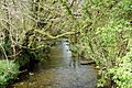
The young River Camel at Slaughterbridge near Camelford
-
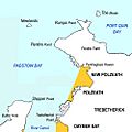
A map showing the River Camel's estuary, where it meets the sea
-
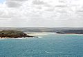
The River Camel's estuary seen from Pentire Point
-
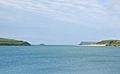
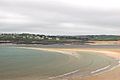
The River Camel estuary looking towards the sea from Padstow
-
The Doom Bar sandbank stretches across the Camel estuary
-
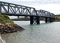
This bridge on the Camel Trail used to carry the North Cornwall Railway over Petherick Creek


