
Pentire Head facts for kids
Quick facts for kids Pentire Head |
|
|---|---|

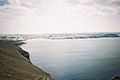
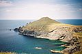
View of Pentire Point taken from Polzeath
|
|

Location in Cornwall
|
|
| Location | Cornwall |
| Coordinates | 50°35′02″N 4°55′08″W / 50.584°N 4.919°W |
Pentire Head is a cool headland in North Cornwall, England. It sticks out into the Atlantic Ocean and is about one mile wide. You can find Pentire Point at its northwest tip and The Rumps at its northeast corner. The name comes from the Cornish words Penn Tir, which means "headland."
Contents
What's in a Name?
The name "Pentire" comes from two old Cornish words: penn meaning "head" and tir meaning "land." So, it literally means "headland." There's another place called Pentire further west, near Crantock, with the same name origin.
Exploring Pentire Head

Pentire Point and Stepper Point are like two gatekeepers at the mouth of the River Camel estuary. Pentire is on the northeast side, and Stepper is on the southwest. Just south of Pentire Point, you'll find the small beach town of Polzeath.
Most of the coastline around Pentire Head is looked after by the National Trust. This group helps protect special places in England. The main part of the headland is a farm called Pentire Farm.
A Special Place for Nature
The whole Pentire Head area is a Site of Special Scientific Interest (SSSI). This means it's a very important place for its unique rocks and wildlife. You can find rare plants here, as well as special types of slate rock from a very old time called the Devonian period.
Look closely, and you might spot different kinds of invertebrates (animals without backbones). Birds of prey soar overhead, and grey seals can sometimes be seen in the waters below. Pentire Head is also special because it has "pillow lavas," a type of rock not found anywhere else in Cornwall. The Rumps area is made of tough "Greenstone," and a rare mineral called Prehnite has been found on the cliffs.
Mining History
Over the years, people tried to find valuable minerals here. Two mines operated on the headland. The first, Pentire mine, started around 1580, digging for lead. Later, in the mid-1800s, another mine called Pentireglaze mine opened. Miners dug deep shafts and even tunnels that went out under the sea! They said they could hear ships passing above them.
An engine house was built on the cliff to help with the mining, but the mines stopped working by 1857. The engine house eventually fell apart and was taken down in 1957. Today, that spot is a National Trust car park, still known as the Lead Mines car park.
Islands Nearby
About a mile northwest of Pentire Point is a small island called Newland. People sometimes call it Puffin Island. Another small island, The Mouls, is just northeast of The Rumps. It's home to many seabirds. After The Rumps, the coastline turns southeast towards Port Quin Bay.
If you love walking, the South West Coast Path follows the edge of the headland. You can also take boat tours from nearby Padstow to see the coast from the water.
History of the Headland
The Iron Age Cliff Castle
On The Rumps, you'll find the remains of an Iron Age "cliff castle." This old fort dates back to the second century BC, which is over 2,200 years ago! It was first written about in 1584 as Pentire Forte.
Archaeologists studied the site between 1963 and 1967. Today, you can see three large banks of earth, called ramparts, that cross the narrow strip of land connecting The Rumps to the main headland. These ramparts were built in different stages. Digs have shown that people lived here in two different periods, with evidence of huts and even a wooden gate. Sadly, this ancient castle is slowly being lost to erosion from the sea.
"For The Fallen" Poem

The famous poet Laurence Binyon wrote his well-known poem, "For the Fallen," while sitting on the cliffs between Pentire Point and The Rumps. This poem was first published in a newspaper called The Times in September 1914.
In 2001, a stone plaque was put up to remember this special moment. It says:
- For The Fallen
- Composed on these cliffs 1914
The plaque also includes the fourth stanza, or verse, of the poem, which is often read at remembrance events:
- They shall grow not old, as we that are left grow old
- Age shall not weary them, nor the years condemn
- At the going down of the sun and in the morning
- We will remember them
Gallery of images
-
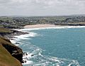
The view from Pentire Point, looking towards Polzeath and Trebetherick Point.
-
Another view of Polzeath from Pentire Point.
-
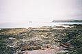
Pentire Point and Puffin island.
-
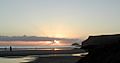
Puffin island and Pentire Point at sunset.
-
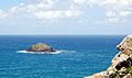
Puffin island seen from Pentire Point.
-
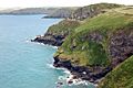
The Rumps, site of Iron Age cliff fortifications.
-
Looking across Port Quin Bay from the east side of Pentire Head.


