
Stepper Point facts for kids
Quick facts for kids Stepper point |
|
|---|---|

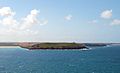
Stepper Point viewed from the east across the River Camel estuary
|
|

Location in Cornwall
|
|
| Location | Cornwall |
| Coordinates | 50°34′08″N 4°57′00″W / 50.569°N 4.950°W |
Stepper Point (Cornish: Penn Stuppert) is a piece of land that sticks out into the Atlantic Ocean. It is located in north Cornwall, England. Stepper Point and Pentire Point are like two gateposts at the entrance of the River Camel. Stepper Point is on the southwest side, and Pentire Point is on the northeast side.
Contents
Exploring Stepper Point's Landscape

Stepper Point rises to about 74 meters (242 feet) at its highest spot. People use the land here for farming. You can also see old stone quarries that are no longer used.
The coast to the east of Stepper Point is part of the River Camel estuary. This side has sandy areas like Tregirls beach and St George's Cove. You can easily reach St George's Cove from the walking path.
A bit further north, you'll find Harbour Cove and Hawker's Cove. These two coves connect at low tide, forming a large sandy beach. This beach is part of a sandbank called Doom Bar at the river's mouth.
Rugged Coastline and Rock Formations
To the southwest of Stepper Point, the coast looks more rugged. There are tall cliffs above a rocky shoreline. About a mile south is another small headland called Gunver Head. A mile further on, you'll find the sandy beach at Trevone.
Off the coast, there's a rocky island called Gulland. Its name might come from the Cornish word goelann, which means gull. The rocks at the outer end of Stepper Point are called Polzeath Slates. Gulland island is made of similar rock.
Because of its special rocks and features, Stepper Point was named a Site of Special Scientific Interest in 1990. This means it's a protected area.
Landmarks and Fun Activities
The highest part of Stepper Point has a stone tower built in 1830. It's 12 meters (40 feet) tall and was made to help sailors find their way during the day. It's called the Daymark and you can see it from over 30 miles out at sea.
The South West Coast Path follows the coastline around Stepper Point. The path from Padstow to Stepper Point is about 5 kilometers (3 miles) long. It's quite easy to walk and has a good surface. Beyond Stepper Point towards Trevone, the path gets rougher.
Watching the Coast
As you walk the coast path, you'll pass both the Daymark and the National Coastwatch Institution lookout. This lookout station helps keep an eye on the sea. Volunteers work there every day from 9 AM. They are part of the official UK Search and Rescue system.
You can also take boat tours from the nearby port of Padstow. These tours travel along the coast, giving you great views of Stepper Point.
Quarrying and Mining History
One noticeable feature on the river side of Stepper Point is an old quarry. It was first used to remove stone. This was done to help sailing ships avoid getting stuck when trying to sail upriver towards Padstow.
After World War I, a company started quarrying again at Stepper Point. They used a small railway to move the stone. The stone was then dropped directly into ships below. During World War II, stone from here was used to build a runway at RNAS St Merryn. Quarrying stopped soon after the war.
Old Mines
Stepper Point also has a history of mining. On the west side, near Gunver Head, there was a mine that produced small amounts of Copper and Silver. On the east side, near Harbour Cove, there was a small lead mine.
Images for kids
-
Stepper Point (with Gunver Head to the right) viewed 'end on' from Pentire Point.
-
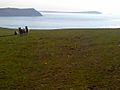
Stepper Point (with Trevose Head in the distance, right), viewed from Pentire Farm.
-
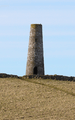
The Daymark.


