Port Quin facts for kids
Quick facts for kids Port Quin
|
|
|---|---|
 Port Quin |
|
| Lua error in Module:Location_map at line 530: Unable to find the specified location map definition: "Module:Location map/data/Cornwall (mainland)" does not exist. | |
| OS grid reference | SW971805 |
| Civil parish |
|
| Unitary authority | |
| Ceremonial county | |
| Region | |
| Country | England |
| Sovereign state | United Kingdom |
| Post town | PORT ISAAC |
| Postcode district | PL29 |
| Dialling code | 01208 |
| Police | Devon and Cornwall |
| Fire | Cornwall |
| Ambulance | South Western |
| EU Parliament | South West England |
| UK Parliament |
|
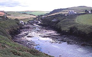
Port Quin is a tiny, pretty cove and small village (called a hamlet) found on the north coast of Cornwall, England. It sits between the villages of Port Isaac and Polzeath. Its Cornish name, Porth Gwynn, means 'white cove'.
Contents
Exploring Port Quin's Geography
What is Port Quin Like?
Port Quin faces the mighty Atlantic Ocean. It's a narrow, rocky inlet that acts like a natural, safe harbour for boats. The cove is part of a larger area called Port Quin Bay, which stretches about 2.5 miles along the coast, from Kellan Head to The Rumps.
A Place of Natural Beauty
Port Quin is located within the Cornwall Area of Outstanding Natural Beauty (AONB). This means it's a very special place with beautiful landscapes. Almost a third of Cornwall has this AONB protection. It has the same importance as a National Park.
Port Quin's Past: A Look Back in Time
The Name and Early Days
The name "Port Quin" likely comes from the Cornish words "Porth" (meaning harbour) and "gwynn" (meaning white). The village was first mentioned in 1327. Back then, a person named Laurence de Porquin took his name from the village.
Trading and Fishing Life
During the Middle Ages, boats from Port Quin often sailed to Wales. They traded things like coal, manure, antimony, lead, and building stones. Granite from Lundy Island was even brought here to help build the tower of the local church at St Endellion.
The main way people made a living was through fishing, especially for pilchards. The pilchard season ran from August to December. Fresh fish were dried in large sheds in the village. Then, they were taken away to be sold. Farming and small tin mines also helped the local economy.
The Village's Decline
The size of the old fish drying sheds shows that Port Quin was once a busy and successful village. However, by 1841, it started to decline. A count of the population (a census) showed only 94 people lived there in 23 houses.
People began moving to nearby villages. This happened because there weren't as many pilchards or herring to catch. Also, local mines were closing. Many people even moved to Canada, sailing from Padstow.
The Legend of Port Quin
As Port Quin became smaller, a local legend grew. It tells of a disaster at sea. One version says that all the men of the village went fishing on a Sunday. This was against the rules of the Sabbath. A huge storm then hit, destroying their entire fishing fleet and drowning all the men. Another story says all the men were on one fishing boat, but it doesn't mention a storm.
Shipwrecks and Follies
In February 1700, a ship called the Thornton, which was from the East Indies, was wrecked at Port Quin.
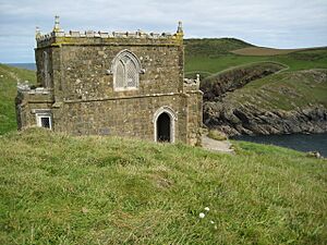
On the south-west side of the inlet, you'll find Doyden Point. Here stands Doyden Castle, which isn't a real castle! It's a "folly," a building made just for fun or decoration. It was built around 1830 by Samuel Symons, a lively gentleman from Wadebridge.
Mines Around Port Quin
There were two old mines near Port Quin. Port Quin Mine dug for a metal called Antimony. Gilson's Cove Mine, located on the cliffs beyond Doyden, produced lead ore.
Port Quin Today
What to See and Do
Today, the harbour is surrounded by three local farms: Roscarrock, Trevigo, and Scarrabine. These are all run by local families. The National Trust owns some parts of Port Quin, including a few small fields. They rent out some of the old stone cottages for holidays.
The South West Coast Path follows the beautiful coastline around Port Quin. This makes it a popular spot for walkers and kayakers. There's a small car park, and during summer, you might find a mobile vintage cafe there. A sea kayaking company called Cornish Coast Adventures also operates from the harbour. They offer tours between Easter and October, exploring the old Antimony mines and the coastline.
Port Quin on Screen
Filming Location
Port Quin has been used as a filming location for several TV shows.
 | May Edward Chinn |
 | Rebecca Cole |
 | Alexa Canady |
 | Dorothy Lavinia Brown |


