River Ottery facts for kids
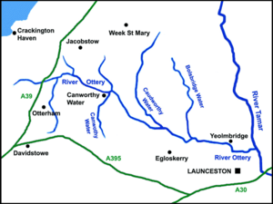
The River Ottery (called Otri in the Cornish language) is a small river in the northeast part of Cornwall, United Kingdom. It flows for about 32 kilometers (20 miles). The river starts southeast of Otterham and joins the River Tamar at Nether Bridge. This meeting point is about 3 kilometers (2 miles) northeast of Launceston.
The very beginning of the River Ottery, called its headwaters, is in the area known as Otterham. Long ago, in 1311, a local church leader wrote about the river. He said the Ottery starts in his area and flows through places like Canworthy Water and Yeolmbridge before reaching the River Tamar.
Contents
What is the River Ottery's Journey Like?
The River Ottery and its smaller streams, called tributaries, form a big part of the Tamar river system. Together, they drain an area of about 124 square kilometers (48 square miles) in north Cornwall. The land where the River Ottery collects its water, known as its catchment area, is made of a type of rock called the Culm Measures. This rock stretches from Dartmoor to north Devon and across northeast Cornwall.
The young river first flows north until it reaches a tiny village called Trengune. From there, it turns and flows towards the east-southeast. It keeps this direction until it meets the River Tamar.
Which Streams Join the River Ottery?
The biggest streams that join the River Ottery are Caudworthy Water and Bolsbridge Water. These two streams flow into the Ottery from the north. Another important stream, Canworthy Water, joins the River Ottery from the south.
Has the River Ottery Ever Flooded?
Yes, the River Ottery and its streams were badly affected by a big flood in north Cornwall on August 16, 2004. On that day, a huge amount of rain, up to 20 centimeters (8 inches), fell in just one afternoon. The areas where the Ottery begins, near Marshgate and Otterham, were hit the hardest by this flood.
The river flows through a quiet area where people do different kinds of farming. The only places with houses right along the river are Canworthy Water and Yeolmbridge.
What Wildlife Lives in the River Ottery?
The Cornwall Rivers Project is a group that studies rivers in Cornwall. They have found five special areas along the Ottery that are important for nature. These are called Sites of Special Scientific Interest (SSSI). One of these, the Ottery Valley SSSI, has 33 hectares of a special type of wet grassland habitat. Another, Kernick and Ottery Meadows SSSI, is also important for its plants and animals.
The project also says that the River Ottery is home to many different kinds of wildlife. This includes fish like trout and other fish that travel to and from the sea. You might also see otters, bright kingfishers, and sand martins flying around. Birds like dippers, curlews, and snipe also live there. If you are lucky, you might even spot the beautiful marsh fritillary butterfly.
What is the River Ottery's History?
For a long time, the River Tamar has been the border between Cornwall and Devon. Most old Celtic place-names in Cornwall, like those starting with tre- (meaning 'farm' or 'settlement'), stop right at the Tamar. This shows how old this border is.
However, the part of Cornwall north of the River Ottery is different. It has fewer tre- names and many more names that come from the Anglo-Saxons. These names often end in -dun (meaning 'hill') or -cot (meaning 'cottage'). This suggests that the River Ottery was an early border. It separated the old kingdom of Dumnonia (which was Cornwall) from the Anglo-Saxon kingdom of Wessex as it grew westward.
Where Can You Find the River Ottery?
- The river's start (source) is at these coordinates: 50°40′46″N 4°35′41″W / 50.67944°N 4.59460°W
- Trengune, where the river changes its path, is at: 50°42′37″N 4°33′58″W / 50.71032°N 4.56602°W
- The village of Canworthy Water is at: 50°41′51″N 4°31′01″W / 50.69744°N 4.51693°W
- The village of Yeolmbridge is at: 50°39′43″N 4°22′52″W / 50.66203°N 4.38123°W
- The place where the River Ottery joins the River Tamar is at: 50°39′30″N 4°20′23″W / 50.65828°N 4.33969°W
 | George Robert Carruthers |
 | Patricia Bath |
 | Jan Ernst Matzeliger |
 | Alexander Miles |


