Rivey Hill facts for kids
Quick facts for kids Rivey Hill |
|
|---|---|
| Highest point | |
| Elevation | 367 ft (112 m) |
| Prominence | 69 ft (21 m) |
| Listing | (none) |
| Geography | |
| Location | Cambridgeshire, England |
| OS grid | TL567480 |
| Topo map | OS Landranger 154 |
Rivey Hill is a well-known hill that looks over the village of Linton in Cambridgeshire, England. It stands tall at about 367 feet (112 meters) above sea level. This makes it the highest point for many miles around.
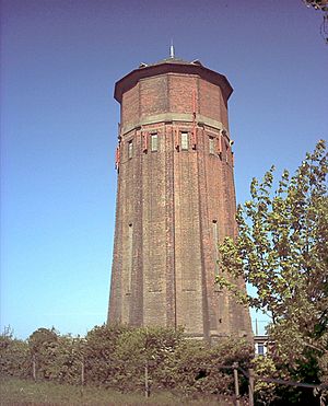
The hill has a steep side that goes down towards Linton. It also has a "prominence" of 69 feet (21 meters). This means it rises clearly above the land right around its base. Even though the very top of Rivey Hill is on private land, a public path called a bridleway crosses close to the summit. A tall watertower sits on the hill. It helps people easily spot Rivey Hill from far away.
Exploring Rivey Hill
Rivey Hill is a great place for outdoor adventures. Many people enjoy walking and exploring the area.
What Makes Rivey Hill Special?
Rivey Hill is important because it's one of the highest points in this part of Cambridgeshire. Its height offers wide views of the surrounding countryside. The water tower on its top is a famous landmark. It helps people know where Rivey Hill is, even from a distance.
Walks and Views
Starting your walk up Rivey Hill can be the beginning of a longer journey. There's a popular circular walk that begins here. This path goes north from the top of Rivey Hill. It leads to an old Roman Road.
The walk then follows this ancient road over another hill called Hildersham Hill, which is about 312 feet (95 meters) high. You'll walk along this path for about 2 miles (3.2 kilometers). After that, the path goes down into the village of Hildersham. Finally, the walk returns to Linton by following the beautiful valley of the River Granta. This walk lets you see different landscapes and historical paths.


