Rolling Fields, Kentucky facts for kids
Quick facts for kids
Rolling Fields, Kentucky
|
|
|---|---|

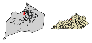
Location of Rolling Fields in Jefferson County, Kentucky
|
|
| Country | United States |
| State | Kentucky |
| County | Jefferson |
| Area | |
| • Total | 0.23 sq mi (0.60 km2) |
| • Land | 0.23 sq mi (0.60 km2) |
| • Water | 0.00 sq mi (0.00 km2) |
| Elevation | 561 ft (171 m) |
| Population
(2020)
|
|
| • Total | 720 |
| • Density | 3,103.45/sq mi (1,197.05/km2) |
| Time zone | UTC-5 (Eastern (EST)) |
| • Summer (DST) | UTC-4 (EDT) |
| ZIP Code |
40207
|
| FIPS code | 21-66486 |
| GNIS feature ID | 2404645 |
Rolling Fields is a small city in Jefferson County, Kentucky, United States. It is known as a "home rule-class city," which means it has the power to manage its own local government. In 2010, about 646 people lived there. The city officially became a city in 1958.
In 2000, Rolling Fields was one of the wealthiest cities in Kentucky. This was based on the average income of families living there. It is located next to other small cities like Indian Hills and Mockingbird Valley. All three cities share the same police department, the Indian Hills Police Department.
Before it became a city, the land where Rolling Fields now stands was part of the Veech family farm for over 100 years. Parts of this farm were also used to build Indian Hills and the nearby Louisville Country Club. Most of the houses in Rolling Fields were built in the 1940s and 1950s.
Where is Rolling Fields Located?
Rolling Fields is in the northern part of Jefferson County. It shares borders with Mockingbird Valley to the west and Indian Hills to the east. The rest of its borders are with the larger area of Louisville/Jefferson County. It is about 5 miles (8 kilometers) east of downtown Louisville.
The United States Census Bureau says that Rolling Fields covers a total area of 0.23 square miles (0.60 square kilometers). All of this area is land, with no water.
Who Lives in Rolling Fields?
| Historical population | |||
|---|---|---|---|
| Census | Pop. | %± | |
| 1960 | 816 | — | |
| 1970 | 714 | −12.5% | |
| 1980 | 731 | 2.4% | |
| 1990 | 593 | −18.9% | |
| 2000 | 648 | 9.3% | |
| 2010 | 646 | −0.3% | |
| 2020 | 720 | 11.5% | |
| U.S. Decennial Census | |||
Based on the census from 2000, there were 648 people living in Rolling Fields. These people lived in 253 households, and 195 of these were families. The city had about 2,688 people per square mile (1,038 people per square kilometer).
Most of the people living in the city were White (99.07%). A small number were African American (0.15%) or Asian (0.15%). About 0.62% were from other backgrounds. People of Hispanic or Latino origin made up 0.46% of the population.
In 2000, about 36.8% of households had children under 18 living with them. Most households (70.0%) were married couples. About 19.8% of all households were single individuals. About 13.8% of people lived alone and were 65 years old or older. The average household had 2.56 people.
The population of Rolling Fields was spread out by age. About 28.7% were under 18 years old. About 20.2% were 65 years or older. The average age in the city was 44 years.
In 2000, the average income for a household in the city was $122,386. For families, the average income was $138,765. The average income per person in the city was $73,152. Very few people (1.5%) lived below the poverty line. This included no one under 18 and 2.4% of those over 64.
See also
In Spanish: Rolling Fields (Kentucky) para niños
 | Charles R. Drew |
 | Benjamin Banneker |
 | Jane C. Wright |
 | Roger Arliner Young |


