Rosemont, California facts for kids
Quick facts for kids
Rosemont
|
|
|---|---|

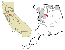
Location in Sacramento County and the state of California
|
|
| Country | |
| State | |
| County | Sacramento |
| Area | |
| • Total | 4.349 sq mi (11.26 km2) |
| • Land | 4.349 sq mi (11.26 km2) |
| • Water | 0 sq mi (0 km2) 0% |
| Elevation | 49 ft (15 m) |
| Population
(2020)
|
|
| • Total | 23,510 |
| • Density | 5,405.8/sq mi (2,087.2/km2) |
| Time zone | UTC-8 (PST) |
| • Summer (DST) | UTC-7 (PDT) |
| ZIP code |
95826, 95827
|
| Area code(s) | 916, 279 |
| FIPS code | 06-62910 |
| GNIS feature ID | 1659543 |
Rosemont is a special kind of community in Sacramento County, California, United States. It's called a census-designated place (CDP). This means it's an area that looks like a town but doesn't have its own local government. It's part of the bigger Sacramento metropolitan area. In 2020, about 23,510 people lived in Rosemont.
Contents
Where is Rosemont?
Rosemont is located in California at these coordinates: 38°32′58″N 121°21′22″W / 38.54944°N 121.35611°W. It covers an area of about 4.3 square miles (11 square kilometers). All of this area is land, with no large bodies of water.
Who Lives in Rosemont?
This section shares information about the people living in Rosemont, based on official counts called "censuses."
People in 2010
The 2010 census showed that 22,681 people lived in Rosemont. Most people (about 59.5%) were White. There were also many African American (12.0%), Asian (10.7%), and Native American (1.4%) residents. About 20.2% of the people were of Hispanic or Latino background.
Most people (98.7%) lived in regular homes. The average household had about 2.68 people. The average family size was 3.18 people.
About 24.4% of the people were under 18 years old. The average age in Rosemont was 33.9 years.
People in 2000
In the year 2000, Rosemont had 22,904 residents. The racial makeup was similar to 2010. About 64.49% were White, 10.90% African American, and 11.17% Asian. About 13.20% of the population was Hispanic or Latino.
About 27.1% of the people were under 18 years old. The average age was 31 years.
What's Rosemont Like?
Rosemont has clear boundaries: Folsom Boulevard to the north, Bradshaw Road to the east, Jackson Highway to the south, and South Watt Avenue to the west. The main shopping and dining areas are mostly along Kiefer Boulevard. You can find all kinds of homes in Rosemont, from older ones built in the 1950s to brand new houses.
There's a group called the Rosemont Community Association (RCA). It's a volunteer group that helps the community. They speak up for Rosemont on local issues and organize fun events and programs for everyone.
Schools in Rosemont
Rosemont has several schools for kids of different ages:
- Elementary Schools: There are three elementary schools: Golden Empire Elementary, Sequoia Elementary, and James W. Marshall Elementary.
- Middle School: Albert Einstein Middle School is the only middle school in the community. It's named after the famous scientist.
- High School: Rosemont High School opened in 2003.
All these schools are part of the Sacramento City Unified School District.
Getting Around Rosemont
Getting around Rosemont is easy!
- Light Rail: The "Gold Line" of the Sacramento light rail system runs along Folsom Boulevard. You can catch a train at stations like Watt/Manlove, Starfire, Tiber, and Butterfield.
- Buses: Bus 72 is a main bus route that goes through the middle of Rosemont.
- Main Roads: Important roads for driving include Kiefer Boulevard, South Watt Avenue, Mayhew Road, Bradshaw Road, and Folsom Boulevard. U.S. Route 50 also passes through the northeastern part of Rosemont.
Nearby Places
 |
Sacramento, La Riviera | La Riviera | Rancho Cordova |  |
| Sacramento | Lincoln Village, Rancho Cordova | |||
| Sacramento | Florin | Vineyard |
Famous People from Rosemont
- Anthony Padilla and Ian Hecox – These are internet comedians famous for their YouTube channel, Smosh. They filmed many of their videos in Ian Hecox's home in Rosemont until 2016.
See also

- In Spanish: Rosemont (California) para niños
 | Jewel Prestage |
 | Ella Baker |
 | Fannie Lou Hamer |

