
Rosslyn, Queensland facts for kids
Quick facts for kids RosslynQueensland |
|||||||||||||||
|---|---|---|---|---|---|---|---|---|---|---|---|---|---|---|---|

Rosslyn
Location in Queensland
|
|||||||||||||||
| Population | 574 (2016 census) | ||||||||||||||
| Postcode(s) | 4703 | ||||||||||||||
| LGA(s) | Shire of Livingstone | ||||||||||||||
| State electorate(s) | Keppel | ||||||||||||||
| Federal Division(s) | Capricornia | ||||||||||||||
|
|||||||||||||||
Rosslyn is a small town located right on the coast in Queensland, Australia. It's part of an area called the Capricorn Coast and is managed by the Shire of Livingstone. In 2016, about 574 people lived there.
Where is Rosslyn?
Rosslyn is a coastal town. It sits along the beautiful beaches near a rocky point called Statue Rock. This rock sticks out into the Coral Sea.
- The northern part of Rosslyn follows the coast. It starts at Statue Rock, goes along Statue Bay, and reaches Rosslyn Head.
- Rosslyn Head is where you'll find the Rosslyn Bay Boat Harbour, a place where boats are kept.
- The eastern side of Rosslyn also follows the coast. It goes from Rosslyn Head along Kemp Beach to another point called Bluff Point.
The Scenic Highway is a main road that runs through Rosslyn. It helps people travel along the coast.
Nature and Parks
Most of the land in Rosslyn is still natural and undeveloped.
- The area around Rosslyn Head is mostly a special protected place called the Capricorn Coast National Park. This park helps protect the natural environment.
- Inside the park, there's a marina for boats and a resort for visitors.
- Bluff Point is also part of this national park.
- Many inland areas of Rosslyn are "Crown land." This means the land is owned and managed by the Queensland Government for everyone.
Images for kids
-
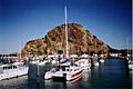
Marina, 2004


All content from Kiddle encyclopedia articles (including the article images and facts) can be freely used under Attribution-ShareAlike license, unless stated otherwise. Cite this article:
Rosslyn, Queensland Facts for Kids. Kiddle Encyclopedia.