Capricorn Coast facts for kids
Quick facts for kids Capricorn CoastQueensland |
|
|---|---|
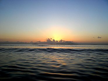
Sunrise over Great Keppel Island
|
|
| Postcode(s) | 4702, 4703, 4710 |
| Location |
|
| LGA(s) | Rockhampton Region |
| State electorate(s) | Keppel |
| Federal Division(s) | Capricornia |
The Capricorn Coast is a beautiful stretch of coastline in Central Queensland, Australia. It's part of the Shire of Livingstone, which used to be part of the Rockhampton Region. This area is known for its stunning beaches and islands.
Contents
- Exploring the Capricorn Coast's Location
- How the Capricorn Coast is Governed
- Towns and Localities Along the Coast
- Understanding the Capricorn Coast's Landscape
- Climate of the Capricorn Coast
- A Look at the Capricorn Coast's History
- Facilities and Infrastructure
- Environmental Concerns
- Tourism and Fun Activities
Exploring the Capricorn Coast's Location
The Capricorn Coast gets its name from Cape Capricorn on Curtis Island. This cape is close to the Tropic of Capricorn, an imaginary line around the Earth. The Tropic of Capricorn actually passes right through the Capricorn Coast!
The official boundaries of the Capricorn Coast are between the mouth of Water Park Creek and the mouth of the Fitzroy River. This means it stretches from Farnborough to Thompson Point. The coast is about 75 kilometers long. Even though it's quite long, it has many small towns and islands. This region has a rich history that goes back to the 1850s.
The Capricorn Coast offers many places to stay, from fancy resorts to cozy bush retreats. You can enjoy lots of activities like snorkeling, island trips, and bushwalking. There's also a wildlife sanctuary at Cooberie and a crocodile farm at Coowonga.
How the Capricorn Coast is Governed
In 1879, the Gogango Divisional Board was set up to manage a large area north and east of Rockhampton. Later, in 1903, this board was renamed the Shire of Livingstone.
The boundaries of the Livingstone Shire stayed mostly the same for a long time. But in 2008, the Livingstone Shire joined with other areas to form the new Rockhampton Region. This change caused some disagreement. However, in 2013, people in the former Livingstone Shire voted to become separate again. So, the Shire of Livingstone was re-established on January 1, 2014.
Towns and Localities Along the Coast
Here are some of the coastal towns and areas you'll find on the Capricorn Coast, listed from north to south:
- Farnborough (including Bangalee)
- Yeppoon
- Cooee Bay
- Lammermoor
- Rosslyn
- Mulambin
- Causeway Lake
- Kinka Beach
- Emu Park
- Zilzie
- Keppel Sands
- Joskeleigh
- Thompson Point
Understanding the Capricorn Coast's Landscape
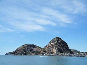
The Capricorn Coast has long, beautiful beaches and shallow seas. You'll see rocky outcrops, which are actually what's left of old volcanoes! The soil inland is red, which is great for growing many fruit crops. Some areas have darker soils, good for grazing animals. In the north, hills rise to form the Byfield Range, home to ancient rainforests.
Most people on the Capricorn Coast live around Yeppoon and Emu Park. These two towns are connected by the Scenic Highway, which follows the coastline with its many coves and beaches. These headlands are old volcanic rocks that helped create the shallow beaches. The towns are also linked by an inland road called Western Yeppoon-Emu Park Road.
Further south, across Coorooman Creek, is Keppel Sands. It's a small town but important for people living in nearby rural areas like Joskeleigh and Coowonga.
Just offshore, you can see Great Keppel Island, a popular place for tourists. Many smaller islands and atolls are also scattered along the coast.
Different Parts of the Capricorn Coast
The Capricorn Coast is quite large, so it has four main sections:
- Northern Section: From Stanage Bay to Bungundarra. This area has very few people, with wetlands, rainforests, and protected areas.
- Central Section: South of Bungundarra to Zilzie. This is where most people live, with beaches and both urban and rural areas.
- Southern Section: South and inland from Zilzie to the Fitzroy River. This part has fewer people, with beaches, tidal flats, and small village communities.
- Offshore Islands: Islands in Keppel and Shoalwater Bays. These have very few people and are mainly for tourism and conservation.
Exploring the Northern Coast

Towns and areas in the northern part include Byfield, Farnborough, and Shoalwater Bay. Just north of Yeppoon, the landscape changes from flat pastures to rolling hills, mountains, and streams.
Red Rock and Waterpark Creek are popular camping spots. Byfield also has Fern's Hideaway, a holiday retreat by Waterpark Creek. Along the coast, beautiful beaches are backed by the Iwasaki and Shoalwater Wetlands, which are important natural areas. Five Rocks is a popular spot for camping and 4WD adventures. Beyond that are the wild areas of Shoalwater Bay and Townshend Island.
Discovering the Central Coast

The central part of the Capricorn Coast stretches for 40 kilometers, from Farnborough in the north to Zilzie in the south. It has many seaside communities and the main towns of Yeppoon and Emu Park. You can clearly see Great Keppel Island from every beach here.
Yeppoon and Emu Park are connected by the Scenic Highway. South of Yeppoon are communities like Cooee Bay and Taranganba, and then Lammermoor beach, known for its clean sands. Further south is Keppel Bay Marina at Rosslyn Bay, a large marina for boats. You'll also find Kemp Beach, Mulambin Beach, and Causeway Lake, where you can rent boats. Across the bridge is Kinka Beach, leading to Emu Park and Zilzie.
Visiting the Southern Coast
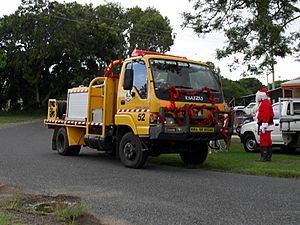
The southern part of the Capricorn Coast includes rural and seaside communities like Coowonga, Joskeleigh, and Keppel Sands. These communities are often centered around waterways like Coorooman Creek and the Fitzroy River.
Fishing and boating are popular activities here. Local community events and support groups, like the Rural Fire Brigade, are very active.
The Offshore Islands
The bays of the Capricorn Coast are dotted with many islands and atolls. These include Great Keppel Island, Keppel Bay Islands National Park (with islands like Pelican Island and Humpy Island), and Pumpkin Island. These islands are mostly for tourism and conservation.
Climate of the Capricorn Coast
The Capricorn Coast has a warm, humid climate. It experiences hot summers, but not as extremely humid as Far North Queensland. Winters are mild, without freezing temperatures. This pleasant year-round weather makes it a great place to live and visit.
| Climate data for Yeppoon The Esplanade | |||||||||||||
|---|---|---|---|---|---|---|---|---|---|---|---|---|---|
| Month | Jan | Feb | Mar | Apr | May | Jun | Jul | Aug | Sep | Oct | Nov | Dec | Year |
| Mean daily maximum °C (°F) | 29.3 (84.7) |
29.3 (84.7) |
28.4 (83.1) |
26.6 (79.9) |
24.2 (75.6) |
21.9 (71.4) |
21.4 (70.5) |
22.1 (71.8) |
24.3 (75.7) |
26.1 (79.0) |
27.4 (81.3) |
28.8 (83.8) |
25.8 (78.4) |
| Mean daily minimum °C (°F) | 23.7 (74.7) |
23.7 (74.7) |
22.4 (72.3) |
19.7 (67.5) |
15.6 (60.1) |
13.3 (55.9) |
11.7 (53.1) |
12.7 (54.9) |
15.6 (60.1) |
19.1 (66.4) |
21.3 (70.3) |
22.8 (73.0) |
18.5 (65.3) |
| Average precipitation mm (inches) | 123.5 (4.86) |
170.4 (6.71) |
90.1 (3.55) |
70.4 (2.77) |
74.4 (2.93) |
59.1 (2.33) |
25.6 (1.01) |
40.3 (1.59) |
36.8 (1.45) |
48.8 (1.92) |
74.5 (2.93) |
131.0 (5.16) |
928.8 (36.57) |
| Source: Australian Bureau of Meteorology | |||||||||||||
A Look at the Capricorn Coast's History
Indigenous Peoples of the Coast
The Capricorn Coast is the traditional land of the Darumbal Aboriginal peoples. The Keppel Bay Islands National Park offshore is home to the Kanomi-Woppaburra people, also known as the Keppel Islanders.
For a long time, different groups of Aboriginal people lived in harmony on the mainland and islands. However, when European settlers arrived in the late 1860s, the Kanomi people were sadly forced to leave North Keppel Island. The last of the Keppel Islanders were removed by the Queensland Government in 1912. Today, the Darumbal Dreamtime Centre in Rockhampton helps share Aboriginal culture.
European Settlement and Growth
Early Discoveries
The Capricorn Coast was first explored by James Cook in 1770. He named several places, like Cape Capricorn and Keppel Bay. Later, Matthew Flinders explored the area in more detail in 1804. Matthew Flinders Drive, a scenic road in Cooee Bay, is named after him.
Other explorers like Phillip Parker King and Captain Francis Price Blackwood also visited the coast. In the 1840s, Ludwig Leichhardt and Thomas Mitchell explored the area that would become Rockhampton, noting its good grazing lands. In 1853, the Archer brothers settled nearby, and by 1858, the town of Rockhampton was officially established.
How Towns Grew
In 1867, the area for Yeppoon was surveyed and chosen for settlement. The name "Yapoon" is believed to come from the local Darumbal people. At first, settlement was slow, as the rich soil attracted farmers more than townspeople. But things changed when regular stagecoach services started from Rockhampton, and copper and gold mining increased in the nearby areas of Cawarral and Mount Chalmers.
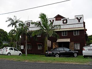
By 1889, Yeppoon was growing, with hotels, a sugar mill, and its first state school, which is now a heritage building.

As farming grew, better transportation was needed. Steam wagons helped open up new communities north of Yeppoon. Areas like Woodbury, Byfield, and Bungundarra became settled. South of Yeppoon, lands around Taranganba and Lammermoor were also settled.
The new town of Emu Park also grew quickly with the completion of the first coastal railway from Rockhampton in 1889. Emu Park and Yeppoon had a friendly rivalry. Emu Park attracted wealthier people, while Yeppoon was popular with gold miners and everyday people. For many years, Causeway Lake separated the two towns. A permanent causeway was built much later, connecting them. This separate history helped Emu Park and Yeppoon develop their own unique characters.
The railway also made it easier to reach Keppel Sands, though the last part of the journey was still difficult due to wetlands. This made Keppel Sands grow slower than other towns. However, the local residents showed great spirit, and the Sand Hills State School opened in 1893.
Today, Joskeleigh is a special place. It's home to one of Australia's most important South Sea Islander communities. These are descendants of people who were brought to Australia to work on plantations.
The Railway's Impact
The railway line to Emu Park opened in late 1888, making travel much easier. New communities and stations popped up along the railway's path. In 1908, a branch line opened to serve the gold towns of Mount Chalmers and Cawarral, reaching Yeppoon in 1909.
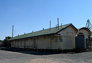
Passenger trains to Yeppoon stopped in 2000 because roads improved. The tracks were removed between 2004 and 2008. In 2008, the Yeppoon Railway Station building was listed as a heritage site. It's one of the few remaining railway terminal stations on the Queensland coast and is still in excellent condition. There are plans to turn the old railway line into a cycling and hiking trail.
The Sugar Industry
The sugar industry on the Capricorn Coast was short-lived, lasting from 1883 to 1903. William Broome started the Yeppoon Sugar Company, and a crushing mill was built at Farnborough. Sugar cane plantations grew in Farnborough, Cawarral, and Joskeleigh.
The sugar business faced challenges like bad weather and low prices. It eventually closed in 1903. Later attempts to restart the sugar industry didn't succeed.
The Story of South Sea Islanders
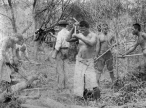
After the sugar industry failed, many South Sea Islanders who had worked on the cane fields faced new challenges. These people had been brought to Australia, often against their will, to work as laborers. This practice was called "blackbirding," which was a form of forced labor or kidnapping. From 1863 to 1904, over 62,000 South Sea Islanders were brought to Queensland for cheap labor. Conditions on the ships were often terrible, and many died.
The Australian government passed laws to stop this practice and deport many Islanders. However, some managed to stay, especially those who had lived in Australia for many years or had children born here. Many white Australians were sympathetic. In Farnborough, some former workers were given jobs, and in the south, land was leased to Islanders to grow crops and raise families. This area became known as Joskeleigh.
The Islanders formed a strong community in Joskeleigh, living in traditional huts and selling vegetables. A school opened in Joskeleigh in 1913. Today, the old headmaster's house is the Joskeleigh Museum, and about thirty Islander families still live there. The term "Kanaka," which once had a negative meaning, is now seen as a badge of honor by many South Sea Islanders, showing their strength and resilience.
Recent History
World War II Presence
During World War II, about 30,000 US soldiers were stationed on the Capricorn Coast. Efforts are being made to preserve the history of their time there, especially at Thompson's Point. St Christopher's Chapel at Nerimbera was built by US soldiers during the war and has been restored.
Shoalwater Bay Military Area
With Australia's involvement in the Vietnam War, a large area including Shoalwater Bay became a military training facility. This area is now called the Shoalwater Bay Military Training Area. The last civilians left their homes there in 1966.
The Iwasaki Resort
In 1971, a Japanese group bought a large area of beachfront land in Farnborough to build a resort. This caused a lot of local concern. Despite the disagreements, the project went ahead. It was first known as the Iwasaki Resort and later became the Capricorn International Resort. It closed in 2016, but there are plans for a big redevelopment, including a new resort, golf course, and homes. This project is expected to create many jobs.
Facilities and Infrastructure
The Capricorn Coast community focuses on a good lifestyle, not just tourism. The economy here is varied, including farming, fishing, and manufacturing.
A large part of Shoalwater Bay is used by the Australian Army for military training. This area, the Shoalwater Bay Military Training Area (SBMTA), often hosts large training exercises with Australian, Singaporean, and US military forces.
Many of the islands along the coast are used for scientific research in marine biology and environmental studies. This brings scientists from all over the world to the area.
Education on the Coast
The Capricorn Coast has many primary and secondary schools, both public and private.
- State primary schools
- Byfield State School
- Cawarral State School
- Emu Park State School
- Farnborough State School
- Keppel Sands State School
- Taranganba State School
- Yeppoon State School
- State secondary schools
- Yeppoon State High School
- North Rockhampton State High School (for students living south of Coowonga)
- Private schools
- Sacred Heart School, Yeppoon (Years Prep to 7)
- St Benedict's School, Pacific Heights (Years Prep to 7)
- St Brendan's College, Yeppoon (Years 8 to 12)
- St Ursula's College, Yeppoon (Years 8 to 12)
- Tertiary colleges
- CQ University, Yeppoon campus (formerly CQ Tafe)
Environmental Concerns
Protecting the Environment
- Shoalwater Bay: In 1994, environmental groups successfully fought against sand mining in Shoalwater Bay, protecting this beautiful wilderness area. More recently, there have been protests about military training exercises in the area.
- Balaclava Island: Plans for a coal terminal on Balaclava Island and dredging near the mouth of the Fitzroy River have raised concerns about their effects on marine life and the Great Barrier Reef.
Tourism and Fun Activities
After a quiet period for tourism, the Capricorn Coast is seeing new life. While some large resorts have closed, there are still many other places to stay. A recent upgrade to the Yeppoon foreshore is helping to attract more visitors. The new Yeppoon Lagoon is a huge, Bali-style pool with a shallow play area for kids, a lap swimming area, and an infinity edge with amazing views. It's free to use and has BBQ facilities.
A short walk north along the main beach is the Keppel Kraken. This is a free water play area on the Yeppoon foreshore, with sea creature sculptures and water cannons. It's a lot of fun for families with young children.
Central to the Capricorn Coast is Keppel Bay Marina at Rosslyn Bay. This is a popular spot for boaters, with 400 berths for vessels. Rosslyn Bay also has restaurants and places to stay.
The main resort on Great Keppel Island has been closed for ten years, but there are plans for redevelopment. You can still find other places to stay and camp on the island. Fast boats leave regularly from Rosslyn Bay, and day-trippers are always welcome.
Further south on the Great Barrier Reef are Heron Island and Lady Elliot Island. These islands are great for snorkeling and diving and can be reached from Gladstone. Lady Musgrave Island is uninhabited, but you can camp there overnight.
A community website, Yeppoon, Capricorn Coast, helps share all the wonderful things the Capricorn Coast has to offer, making it easier for travelers to discover this beautiful region.
 | Emma Amos |
 | Edward Mitchell Bannister |
 | Larry D. Alexander |
 | Ernie Barnes |


