
Rota, Northern Mariana Islands facts for kids
|
Native name:
Luta
|
|
|---|---|

Rota Island in Northern Mariana Islands
|
|

Map showing location of Rota in the western Pacific Ocean
|
|
| Geography | |
| Location | Pacific Ocean |
| Coordinates | 14°09′13″N 145°12′11″E / 14.15361°N 145.20306°E |
| Archipelago | Marianas |
| Area | 85.13 km2 (32.87 sq mi) |
| Length | 19 km (11.8 mi) |
| Width | 8 km (5 mi) |
| Highest elevation | 495 m (1,624 ft) |
| Highest point | Mount Manira |
| Administration | |
|
United States
|
|
| Commonwealth | Northern Mariana Islands |
| Demographics | |
| Population | 1,893 (2020) |


Rota (called Luta by locals) is a beautiful island known as the "Friendly Island." It's the southernmost island in the Northern Mariana Islands, which is a part of the United States. Rota is also the third southernmost island in the larger Marianas group. Long ago, Spanish explorers called it "Zarpana." The name Rota might come from a town in Spain. This island is about 40 nautical miles (74 km) north of Guam. The biggest village on Rota is Sinapalo, followed by Songsong. Rota is also one of the four main areas (called municipalities) that make up the Northern Mariana Islands.
Contents
Exploring Rota's Past

The first European to see Rota was Lope Navarro in 1521. He was a lookout on Ferdinand Magellan's ship. However, Magellan's ships didn't stop there. The first European to actually land on Rota was Juan Sebastián Elcano in 1524. He claimed the island for Spain, along with the other Mariana Islands.
Later, in 1899, Spain sold Rota and other northern Marianas islands to Germany. This happened after a special agreement called the German–Spanish Treaty (1899).
During World War I, Japan took control of these islands. In 1919, the League of Nations (an international group) officially gave Japan control. Japan tried to grow sugar cane on Rota, but it wasn't very successful. By 1935, only about 1,000 Japanese people lived there.
Rota During World War II
During World War II, about 1,600 Japanese soldiers and sailors were stationed on Rota. The U.S. Navy sometimes bombed Rota. This was to stop its radio from warning Japan about American B-29 Superfortress bombers. These bombers were flying from nearby islands like Tinian, Saipan, and Guam.
However, American troops never invaded Rota. Sometimes, B-29 bombers with problems would drop their bombs over Rota before returning to Guam. On September 2, 1945, just after Japan surrendered, U.S. Marines arrived. They accepted the surrender of the Japanese forces on Rota.
After the war, Rota became part of the Trust Territory of the Pacific Islands. Since 1978, it has been part of the Commonwealth of the Northern Mariana Islands. Today, the mayor of Rota is Aubry M. Hocog.
Tourism on Rota
In recent times, tourism has become popular on Rota. People enjoy visiting its natural spots, historic places, and ocean areas. A famous natural wonder is the "swimming hole." This is a small, natural pool of seawater right by the coast. It's a great place to relax and swim.

Geography and Nature
Rota is about 12.3 miles (19.8 km) long and 4.2 miles (6.8 km) wide. Its coastline stretches for about 38 miles (61 km). The highest point on the island is Mount Sabana, which is 495.56 meters (1,625.9 ft) tall.
Rota is located about 47 nautical miles (87 km) north of Guam. It's also 63 nautical miles (117 km) south of Tinian and 73 nautical miles (135 km) south of Saipan.
Amazing Wildlife of Rota
Rota is home to many unique plants and animals. Some of these are found only on Rota. These include the Rota white-eye, a small bird. You can also find the Mariana fruit bat and the Mariana crow. Many parts of the island, especially its native forests, are important areas for birds. BirdLife International has recognized them as an Important Bird Area.
Rota's Climate
| Climate data for Rota Airport (1991–2020 normals, extremes 1993–present) | |||||||||||||
|---|---|---|---|---|---|---|---|---|---|---|---|---|---|
| Month | Jan | Feb | Mar | Apr | May | Jun | Jul | Aug | Sep | Oct | Nov | Dec | Year |
| Record high °F (°C) | 89 (32) |
89 (32) |
89 (32) |
89 (32) |
90 (32) |
94 (34) |
91 (33) |
91 (33) |
96 (36) |
90 (32) |
90 (32) |
89 (32) |
96 (36) |
| Mean daily maximum °F (°C) | 83.6 (28.7) |
83.5 (28.6) |
84.3 (29.1) |
85.1 (29.5) |
86.3 (30.2) |
87.1 (30.6) |
86.7 (30.4) |
85.9 (29.9) |
86.1 (30.1) |
86.1 (30.1) |
85.8 (29.9) |
84.8 (29.3) |
85.4 (29.7) |
| Daily mean °F (°C) | 78.9 (26.1) |
78.6 (25.9) |
79.3 (26.3) |
80.1 (26.7) |
81.2 (27.3) |
81.8 (27.7) |
81.2 (27.3) |
80.5 (26.9) |
80.6 (27.0) |
80.8 (27.1) |
80.8 (27.1) |
80.2 (26.8) |
80.3 (26.8) |
| Mean daily minimum °F (°C) | 74.2 (23.4) |
73.7 (23.2) |
74.2 (23.4) |
75.1 (23.9) |
76.0 (24.4) |
76.6 (24.8) |
75.7 (24.3) |
75.2 (24.0) |
75.1 (23.9) |
75.5 (24.2) |
75.9 (24.4) |
75.5 (24.2) |
75.2 (24.0) |
| Record low °F (°C) | 63 (17) |
61 (16) |
64 (18) |
69 (21) |
66 (19) |
65 (18) |
57 (14) |
64 (18) |
64 (18) |
63 (17) |
69 (21) |
67 (19) |
57 (14) |
| Average precipitation inches (mm) | 5.66 (144) |
4.76 (121) |
3.45 (88) |
3.65 (93) |
3.73 (95) |
5.41 (137) |
9.86 (250) |
14.15 (359) |
15.04 (382) |
13.88 (353) |
7.49 (190) |
5.35 (136) |
92.43 (2,348) |
| Average precipitation days (≥ 0.01 in) | 19.4 | 16.8 | 15.5 | 17.2 | 18.4 | 20.2 | 25.3 | 24.4 | 25.2 | 25.3 | 22.8 | 20.7 | 251.2 |
| Source: NOAA | |||||||||||||
Getting Around Rota
Rota has its own airport, the Rota International Airport. From here, small planes fly to nearby islands. The island also has two harbors for boats. The western harbor was finished in 1985.
Learning on Rota
College and Adult Learning
The Northern Marianas College has a special site on Rota. This site helps people get college education, continue their learning, and get job training. It helps improve life for the people of Rota.
Since 1986, the Rota site has helped many students. They can get college degrees without leaving the island. This saves them money compared to studying elsewhere. Many students have earned certificates or degrees. This has helped them find better jobs and continue their education.
The college offers many programs, including:
- Adult Basic Education (for basic skills)
- Upward Bound (helps prepare for college)
- Educational Talent Search (helps find college opportunities)
- CREES (Agriculture and Aquaculture Extension, about farming and fishing)
- 4H Club (youth development program)
- Expanded Food & Nutrition Education (EFNEP, about healthy eating)
- Business Development Workshops
- Continuing Education Courses
- Community Services Programs
Schools for Kids
The Commonwealth of the Northern Mariana Islands Public School System runs the public schools on Rota.
Rota has two public schools:
- Dr. Rita Hocog Inos Junior & Senior High School: In 2011, the junior high and senior high schools merged. This was to save money. Now, the junior high includes 7th and 8th grades. The 6th grade moved to Sinapalo Elementary. The school is named after a former Commissioner of Education, Dr. Rita Hocog Inos. Its mascot is the Buck.
- Sinapalo Elementary School: This school is located in Sinapalo village.
Rota also has two private schools:
- Eskuelan San Francisco De Borja (ESFDB): This school teaches students from preschool to 8th grade. It's in Songsong Village.
- Grace Christian Academy (GCA): This school teaches students from preschool to 9th grade. It's in Sinapalo Village.
Rota's Public Library
The Antonio C. Atalig Memorial Rota Public Library is in Songsong, Rota. It's part of the State Library of the Commonwealth of the Northern Mariana Islands. The current library building was built around 2002. It officially opened in 2012. It is named after a former mayor of Rota, Antonio C. Atalig.
Images for kids
-
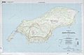
Topographic map of Rota, showing buildings in 1999.
-
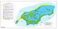
Map showing different soil types on Rota.


See also
 In Spanish: Isla Rota para niños
