
Tinian, Northern Mariana Islands facts for kids

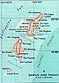
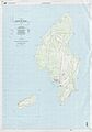
Tinian on an area map, southwest of Saipan, showing waters around islands, and deeper Pacific section.
|
|
 |
|

Tinian
Location in Pacific Ocean
|
|
| Geography | |
|---|---|
| Location | Pacific Ocean |
| Coordinates | 15°00′N 145°38′E / 15.000°N 145.633°E |
| Archipelago | Marianas |
| Area | 101.22 km2 (39.08 sq mi) |
| Highest elevation | 187 m (614 ft) |
| Highest point | Mount Kastiyu |
| Administration | |
|
United States
|
|
| Commonwealth | Northern Mariana Islands |
| Largest settlement | San Jose |
| Demographics | |
| Population | 2,044 (2020) |
Tinian is one of the main islands in the Northern Mariana Islands. This area is a Commonwealth of the United States. Tinian and the nearby island of Aguiguan together form the Tinian Municipality.
Tinian's biggest village is San Jose. The island is located just south of Saipan, which is the most populated island. Tinian is famous for its many WW2 historical sites, cattle ranches, and beautiful beaches. You can travel to Saipan by a short airplane ride or by charter boat. Tinian is part of the United States, and its people are U.S. citizens.
Contents
Island History
First People on Tinian
The Mariana Islands, including Tinian, were the first islands in Remote Oceania where humans settled. This was a very long ocean journey made by the Austronesian peoples around 1500 to 1400 BC. These first settlers came from the Philippines. Later, more people arrived from the Caroline Islands and Island Southeast Asia.
Thousands of years ago, people on Tinian built large stone structures called taga.
Spanish Rule
Europeans first saw Tinian around March 1521. This was during the Spanish trip led by Ferdinand Magellan. The Spanish ship Santa Margarita crashed near Saipan in 1600. Its survivors stayed for two years.
Spain officially took control of Tinian in 1669. A missionary named Diego Luis de San Vitores named it Buenavista Mariana. From 1670, Tinian became a stop for ships to get food and water.
The number of native people, called Chamorros, dropped a lot. This was due to diseases brought by Europeans and fighting over land. In 1720, the remaining Chamorros were moved to Guam. Under Spanish rule, Tinian became a place for raising cattle and pigs. These animals were used to feed Spanish ships sailing to Mexico.
German Rule
After the Spanish–American War in 1898, Spain sold Tinian to the German Empire in 1899. Germany managed the island as part of German New Guinea. During this time, Germany did not try to develop or settle Tinian. The island stayed under the control of its Spanish and mixed-race landowners.
Japanese Rule

In 1914, during World War I, Japan took over Tinian. In 1918, the League of Nations officially gave Japan control. This was part of the South Seas Mandate. Many Japanese, Koreans, and people from Okinawa moved to Tinian. They started large sugar farms.
Japan built many things on the island. These included port facilities, water systems, power stations, paved roads, and schools. They also built places for fun and Shinto shrines. By June 1944, about 15,700 Japanese civilians lived on Tinian. This included 2,700 Koreans and 22 Chamorros.
World War II

Japan did not have many soldiers on Tinian until later in World War II. They then realized Tinian was important for American Boeing B-29 Superfortress bombers. The Allies took the island during the Battle of Tinian. This battle lasted from July 24 to August 1, 1944. Out of 8,500 Japanese soldiers, only 313 survived. Many civilians also died or took their own lives.
Tinian is about 1,500 miles (2,400 km) from mainland Japan. This made it a good place for bombers to attack Japan. After the US took the island, they built the largest airbase of WW2 there. It covered almost the entire island. The Tinian Naval Base was a huge place for 40,000 people. The Navy Seabees built the base like New York City's Manhattan Island. They even named the streets after NYC streets.
The old Japanese town of Sunharon was called "The Village." This was because it was like Greenwich Village in New York. A large open area was called Central Park. Some roads were named Broadway, 42nd Street, and Riverside Drive.
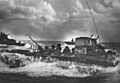
Two big runway areas were built: West Field and North Field. They had a total of six 8,500-foot (2,600 m) runways. Today, the four runways at North Field are overgrown. One of the two West Field runways is still used as part of Tinian International Airport.
West Field

The Japanese first built two runways here. Americans repaired them and called it West Field. From here, seven groups of the 58th Bombardment Wing flew missions. They flew over Southeast Asia and then to the Japanese home islands.
After WW2, West Field became Tinian's airport, called Gurguan Point Airfield. Today, it is Tinian International Airport.
North Field

The Japanese had built three small fighter runways on Tinian. But they were not big enough for bombers. The Americans built runways and taxiways that covered almost the entire northern part of the island. This was to hold all the Boeing B-29 Superfortress bombers of the 313th Bombardment Wing.
North Field was where the special 509th Composite Group B-29 bombers took off. These were the Enola Gay and Bockscar. They carried the two atomic bombs, Little Boy and Fat Man. These bombs were dropped on Hiroshima and Nagasaki.
You can still see parts of the US bomber base and the Atom Bomb Pits at North Field. There are also remains of Japanese forts. A memorial stands at the old airfield where the bombs were loaded. The pits were built because the bombs were too big to be loaded the usual way. The B-29s were moved over a pit with their bomb bay doors open to load the bombs.
Tinian After the War
.jpg)
After World War II, Tinian became part of the Trust Territory of the Pacific Islands. The United States controlled this area. The US military continued to be very active on the island. Since 1978, Tinian has been a municipality of the Commonwealth of the Northern Mariana Islands.
In the 1980s, one runway at North Field was kept open. This allowed US Air Force C-130s to land. They supported US Marine Corps training on the island. On November 4, 1986, the Northern Marianas, including Tinian, became part of the United States. The people living there became US citizens.
After the war, the main businesses were fishing, cattle, and tourism. There are still many ranches and thousands of cattle on Tinian today.
Tinian in the 21st Century
.jpg)
.jpg)
In 2009, Star Marianas Air started flying from Tinian. By the 2010s, this airline flew small planes between Saipan, Guam, Tinian, and Rota.
The Tinian Dynasty Hotel and Casino closed in 2016. The company said a typhoon caused fewer visitors. On October 24, 2018, Typhoon Yutu hit Tinian. It was a very strong storm and caused a lot of damage.
In late 2023, the US House and Senate approved money for Tinian's Divert Airfield. This money is for military use.
Tinian Municipality

Tinian Municipality is one of the four main areas of the Northern Mariana Islands. It includes the islands of Tinian and Aguiguan, plus smaller islands nearby. This municipality is the second southernmost in the Northern Marianas. It has a land area of 108.1 square kilometers (41.7 sq mi).
In 2000, 3,540 people lived there, all on Tinian island. Aguiguan is not inhabited. The main village on Tinian is San Jose. It is located on the southwest coast.
Geography of Tinian

Tinian is about 5 nautical miles (9 km) southwest of Saipan. The Saipan Channel separates the two islands. Tinian has a land area of 39 square miles (101 sq km). Its highest point is on the Kastiyu plateau, at 187 meters (614 ft) high. Tinian is much flatter than Saipan.
The island has limestone cliffs and caves. There is a lot of marine life and coral reefs around the island. The clear, warm waters are great for snorkeling, scuba diving, and fishing. Aguijan island is a small island to the south.
Plants, Wildlife, and Marine Life

Tinian has many different plants and animals. The Tinian monarch is a bird found only on this island. Its home is shrinking, which threatens the bird. The island is known as an Important Bird Area (IBA). This is because it has many birds like Micronesian megapodes and Mariana fruit doves.
Surveys in 1982, 1996, and 2008 found that bird populations are doing well. Native bird species on Tinian include the Mariana Fruit-Dove and the Tinian Monarch.
Population of Tinian
The population of Tinian was 2,044 in 2020. This is less than 5% of all people in the Northern Mariana Islands. The population density is 20 people per square kilometer. Most people living on Tinian are Chamorros (about 75%). Others are from different islands in the Caroline Islands. There are also smaller groups of Filipino, Bangladeshi, East Asian, and European people.
Economy
Tinian's economy mostly relies on tourism. However, there are not many tourist facilities yet. The village of San Jose has some small hotels, restaurants, and bars. Farming is mostly for people to feed themselves. The biggest employers on the island are the government and the casino. Gambling became legal in 1989.
Transportation
Air Travel
.jpg)
Tinian Airport (TIQ) is a small airport. Star Marianas Air flies daily from Tinian to Saipan.
Ferry Service
There used to be a ferry boat service between Tinian and Saipan. It ran twice a day but lost a lot of money. Because of this, the ferry service has stopped.
Fun Places to Visit
House of Taga


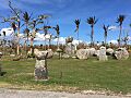
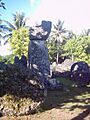
The House of Taga is a site with large latte stones. These are some of the biggest stone structures in the Marianas. The stones are made of limestone and are about 20 feet (6 meters) long. Out of twelve large stone structures, only one is still standing. This site is listed on the National Register of Historic Places listings in the Northern Mariana Islands.
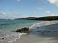
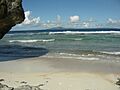
Beaches

Tinian has several beautiful beaches:
- Tachogna, near Taga beach.
- Taga beach, a popular beach where you can jump into the water from a small cliff.
- Chaga, a small beach in the northwest of Tinian.
- Unai Dankulu or Long Beach, which is actually a series of beaches on the northeast side.
In 2022, Chiget Beach was reopened after being cleared. There used to be unexploded bombs on the beach.

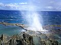
One unique natural wonder is called the blowhole. Here, water shoots up 10 meters (33 ft) into the air. Snorkeling and scuba diving are popular activities in Tinian's clear waters.
.jpg)
Education
The Commonwealth of the Northern Mariana Islands Public School System runs public schools on Tinian. These include Tinian Elementary School and Tinian Jr./Sr. High School.
The State Library of the Commonwealth of the Northern Mariana Islands operates the Tinian Public Library. It is located in San Jose Village.
Images for kids
-
Tinian on an area map, southwest of Saipan, showing waters around islands, and deeper Pacific section.
-
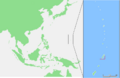
Map of Tinian in the Pacific Ocean.
-
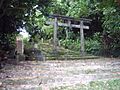
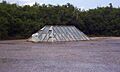
Tinian Shinto shrine.
-
U.S. Marines during the Battle of Tinian in 1944.
-
The atom bomb pit "No.1" on Tinian's North Field, where Little Boy was loaded aboard the Enola Gay.
-
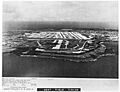
West Field, Tinian, July 8, 1945.
-
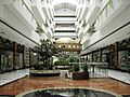
Tinian Dynasty Hotel lobby in 2011, it operated from 1998 to 2015.
-
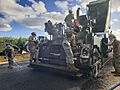
US Navy Seabees construct a road on Tinian in 2020.
-
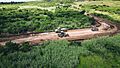
Another view of US Navy Seabees constructing a road on Tinian in 2020.
-

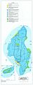
Map of the four municipalities of CNMI, with Tinian Municipality highlighted in red.
-
Topographic map of the island of Tinian, showing buildings as of 1999.
-
Map of soil types on the islands of Tinian and Aguijan.
-
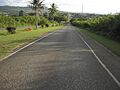
A road on Tinian.
-
The ruins of the House of Taga stones after Typhoon Yutu.
-
House of Taga, Tinian.
-
A beach on Tinian.
-
Tinian Blowhole, a natural water geyser by the coast.
-
Masalok Beach on Tinian.
See also
 In Spanish: Tinián para niños
