Maritime Southeast Asia facts for kids
| Geography | |
|---|---|
| Location | Indonesian Archipelago Philippine Archipelago Peninsular Malaysia East Malaysia Singapore |
| Total islands | 25,000 |
| Major islands | Borneo, Java, Luzon, Mindanao, Sulawesi, Sumatra |
| Area | 2,870,000 km2 (1,110,000 sq mi) |
| Highest elevation | 4,095 m (13,435 ft) |
| Highest point | Mount Kinabalu |
| Largest settlement | Bandar Seri Begawan |
| Largest settlement | Jakarta |
| Largest settlement | Kuala Lumpur |
| Largest settlement | Quezon City |
| Largest settlement | Singapore |
| Largest settlement | Dili |
| Demographics | |
| Population | 380,000,000 |
| Ethnic groups | Predominantly Austronesians, with minorities of Negritoes, Papuans, Melanesians, descendants of Chinese (including Peranakans), Arab descendants, Eurasians, Mestizos, Orang Asli and descendants of Overseas Indians and Sri Lankans |

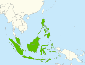
Maritime Southeast Asia is a huge area made up of many islands. It includes countries like Brunei, Indonesia, Malaysia, the Philippines, Singapore, and East Timor. You might also hear it called Island Southeast Asia or Insular Southeast Asia.
This region is famous for having a massive number of islands. It also has some of the richest variety of plants, animals, and sea life on Earth. Imagine how many different kinds of creatures live here!
Most people in Maritime Southeast Asia belong to groups called Austronesians. This is a big difference from Mainland Southeast Asia. Even though there are huge cities here, like Manila and Jakarta, many islands in this vast area are still empty, with no people living on them.
Contents
Exploring the Geography of Maritime Southeast Asia
This amazing region covers more than 2 million square kilometers of land and sea. It has over 25,000 islands, which are grouped into many smaller chains.
Major Island Groups and Countries
The main island groups and countries in Maritime Southeast Asia are:
- Peninsular Malaysia
- Singapore, Indonesia, East Timor, East Malaysia and Brunei
- Sunda Islands
- Greater Sunda Islands
- Lesser Sunda Islands
- Maluku Islands
- Sunda Islands
- Philippines
- Visayan Islands
- Sulu Archipelago
The seven biggest islands are Borneo, Sumatra, Sulawesi, and Java (all in Indonesia). Also, Luzon and Mindanao are major islands in the Philippines.
A Land of Volcanoes and Mountains
Geologically, this area is one of the most active volcanic regions in the world. You'll find many volcanoes here, especially on Java, Sumatra, and the Lesser Sunda Islands. Many of these volcanoes are over 3,000 meters tall!
Huge mountains have also been formed by tectonic plate movements. The highest mountain is Mount Kinabalu in Sabah, Malaysia, standing at 4,095.2 meters. Another very tall one is Puncak Jaya in Papua, Indonesia, which is 4,884 meters high.
Because it's located near the Equator, the climate across all these islands is tropical. This means it's warm and often humid all year round.
Amazing Biodiversity: Plants and Animals

Island Southeast Asia is special because it's crossed by the Wallace Line. This imaginary line separates the plants and animals of Asia from those of Australia and New Guinea. The water gaps along this line have always been too wide for many species to cross easily. This means that animals and plants on one side are often very different from those on the other.
There's also a special area next to the Wallace Line called Wallacea. In this zone, you can find some animal and plant species from both sides. However, on smaller islands, there might be fewer types of land animals.
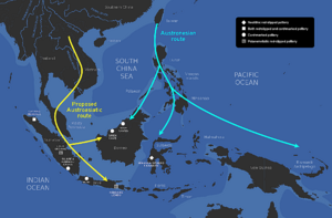
This division is very important for understanding how humans, both ancient and modern, spread across the region. The Wallace Line was a sea barrier that always existed, even when sea levels were at their lowest during ice ages. This tells us that early humans must have used some kind of boats to cross these waters.
Culture and People of the Islands
As of 2017, more than 540 million people live in this region. The island of Java is the most populated. Most people here are from Austronesian groups. They speak languages that are part of the western Malayo-Polynesian languages family.
This part of Southeast Asia shares many social and cultural connections. These ties are with people from mainland Southeast Asia and with other Austronesian groups in the Pacific.
Islam is the main religion in many parts of the region. However, Christianity is the main religion in the Philippines and East Timor. You will also find large groups of people who practice Buddhism, Hinduism, and traditional Animism.
A Rich History of Trade and Exploration
The way people traveled and traded by sea in this region made it a unique cultural and economic area. This is especially true when compared to the land-based societies of mainland Southeast Asia. The region was largely shaped by the sea-faring cultures of the Austronesian peoples.
Ancient Indian Ocean Trade Routes
The first long-distance sea trade in the Indian Ocean was started by the Austronesian peoples from Island Southeast Asia. They began trading with Southern India and Sri Lanka as early as 1500 BC. This led to the exchange of goods like catamarans (a type of boat), coconuts, and sandalwood.
People from Indonesia, for example, traded spices like cinnamon with East Africa. They used special boats and sailed with the help of winds in the Indian Ocean. This trade network grew so much that Austronesians even settled in Madagascar by the first half of the first millennium AD.
The Famous Maritime Silk Road
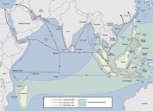
Around 200 BCE, the ancient Austronesian trade networks in Southeast Asia connected with other sea trade routes. These routes linked South Asia, the Middle East, eastern Africa, and the Mediterranean. This huge network became known as the Maritime Silk Route (or Maritime Silk Road).
Besides Austronesian sailors, Tamil, Persian, and Arab sailors also used this route a lot. It allowed goods to be exchanged from East and Southeast Asia all the way to Europe and eastern Africa.
Many different goods were carried on these trading ships. They included ceramics, glass, beads, jewels, ivory, fragrant wood, metals, textiles (like silk), food, and spices. For example, Ivory was a very important export from East Africa.
The Maritime Silk Route was very busy until about the 15th century CE. Records from ancient Chinese dynasties mention large Southeast Asian ships visiting Chinese cities regularly for trade.
Around 900 to 1000 CE, China's population grew a lot. This increased the demand for products from Southeast Asia. Chinese trading ships began sailing to Southeast Asia by the 11th century. However, trade routes during this time were mostly controlled by the Srivijaya kingdom.
Later, Chinese sailors developed their own advanced ships. This led to Chinese trading communities being set up in Southeast Asia. Trade by sea boomed, and Chinese ports like "Chinchew" (Quanzhou) and "Canton" (Guangzhou) became major trade centers.
Trade with China stopped for a while after the Song dynasty fell. But it started again during the Ming dynasty from the 14th to 16th centuries. The famous sea trips of Zheng He between 1405 and 1431 were very important. They helped open up China to more trade with Southeast Asian countries.
The Maritime Silk Route changed when European countries began to explore and colonize in the 15th century. European trade routes took over. The building of the once-dominant Southeast Asian trading ships, called jong, slowly stopped by the 17th century. New demand for spices from Southeast Asia and textiles from India and China now went directly to the European market.
See also
- Southeast Asia
- Philippine archipelago
- Indonesian archipelago
- Maritime Continent
- Malay world
- Malesia
- Peninsular Malaysia
 | Jessica Watkins |
 | Robert Henry Lawrence Jr. |
 | Mae Jemison |
 | Sian Proctor |
 | Guion Bluford |


