
Sabah facts for kids
Quick facts for kids
Sabah
|
|||
|---|---|---|---|
|
|||
| Nickname(s):
Negeri Di Bawah Bayu
Land Below the Wind |
|||
| Motto(s):
Sabah Maju Jaya
Let Sabah Prosper |
|||
| Anthem: Sabah Tanah Airku Sabah My Homeland |
|||

|
|||
| Established under the Bruneian Empire | 15th century | ||
| British North Borneo | 1882 | ||
| Japanese occupation | 1942 | ||
| British crown colony | 15 July 1946 | ||
| Gained self-governance | 31 August 1963 | ||
| Federated into Malaysia | 16 September 1963 | ||
| Capital (and largest city) |
Kota Kinabalu | ||
| Divisions |
List
Interior
Kudat Sandakan Tawau West Coast |
||
| Government | |||
| • Type | Parliamentary | ||
| • Body | Sabah State Legislative Assembly | ||
| Area | |||
| • Total | 73,904 km2 (28,534 sq mi) | ||
| Population
(2018)
|
|||
| • Total | 3,900,000 (2nd) | ||
| Demonym(s) | Sabahan | ||
| Demographics (2010) | |||
| • Ethnic composition |
|
||
| • Dialects | Bornean • Sabah Malay • Hakka Other ethnic minority languages |
||
| State Index | |||
| • HDI (2017) | 0.702 (medium) (13th) | ||
| • TFR (2017) | 1.4 | ||
| • GDP (2016) | RM77,518 million | ||
| Time zone | UTC+8 (MST) | ||
| Postal code |
88xxx to 91xxx
|
||
| Calling code | 087 (Inner District) 088 (Kota Kinabalu & Kudat) 089 (Lahad Datu, Sandakan & Tawau) |
||
| ISO 3166 code | H (MY-12, 47–49) | ||
| Vehicle registration | SA, SAA, SAB, SAC, SY (West Coast) SB (Beaufort) SD (Lahad Datu) SK (Kudat) SS, SSA, SM (Sandakan) ST, STA, SW (Tawau) SU (Keningau) |
||
| Former name | North Borneo | ||
| Official language(s) | |||


Sabah is a state in Malaysia, located on the northern part of Borneo island. It shares land borders with Sarawak (another Malaysian state) and Indonesia's Kalimantan region. The island of Labuan is also nearby. Sabah has sea borders with Vietnam to the west and the Philippines to the north and east.
Kota Kinabalu is Sabah's capital city. It is the main economic hub and where the state government is located. Other important towns include Sandakan and Tawau. In 2015, Sabah had a population of about 3.5 million people.
Sabah has a tropical climate with lush rainforests. These forests are home to many different kinds of animals and plants. The western part of Sabah has long mountain ranges, including the Crocker Range National Park. The Kinabatangan River, Malaysia's second-longest river, flows through Sabah. Mount Kinabalu is the highest point in Sabah and all of Malaysia.
Humans first settled in Sabah about 20,000 to 30,000 years ago near the Darvel Bay area. Sabah traded with China as early as the 14th century. It was influenced by the Bruneian Empire and later by the Sultanate of Sulu. In the 19th century, a British company called the North Borneo Chartered Company took control.
During World War II, Japan occupied Sabah for three years. After the war, it became a British colony again in 1946. Sabah gained self-government from the British on August 31, 1963. On September 16, 1963, Sabah became one of the founding members of the Federation of Malaysia. This federation also included Sarawak, Singapore (which left in 1965), and the Federation of Malaya.
Sabah is known for its many different ethnic groups, cultures, and languages. The head of state is the Governor, called the Yang di-Pertua Negeri. The head of government is the Chief Minister. Sabah's government system is similar to the British parliamentary system.
Sabah is divided into five main areas and 27 districts. Malay is the official language. Islam is the state religion, but people are free to practice other religions peacefully. Sabah is also famous for its traditional musical instrument, the sompoton.
Sabah has many natural resources. Its economy relies heavily on exports like oil, gas, timber, and palm oil. Other important industries are farming and ecotourism, which is tourism focused on nature.
Contents
Exploring Sabah's Environment
Sabah's Geography and Landscapes


Sabah covers about 73,904 square kilometers (28,534 square miles). It is surrounded by three seas: the South China Sea to the west, the Sulu Sea to the northeast, and the Celebes Sea to the southeast. Sabah has a long coastline of about 1,743 kilometers (1,083 miles).
The state has many marine resources because it faces three different seas. Its special economic zone, where it has rights to resources, is larger in the South China Sea and Celebes Sea. Sabah's coastlines are covered with mangrove and nipah forests. Mangroves cover about 331,325 hectares, which is 57% of all mangroves in Malaysia.
Both the west and east coasts have sandy beaches. In sheltered areas, the sand mixes with mud. The northern area of Tanjung Simpang Mengayau has small, curved beaches. The west coast has large freshwater wetlands. The Klias Peninsula has many tidal wetlands. The Kota Kinabalu Wetland Centre was named a special wetland site in 2016.
The western part of Sabah is mostly mountainous. It has three of the highest peaks. The main mountain range is the Crocker Range, with mountains from 1,000 to 4,000 meters high. Next to it is the Trus Madi Range, home to Mount Trus Madi, which is 2,642 meters (8,668 feet) tall.
The highest peak is Mount Kinabalu, standing at about 4,095 meters (13,435 feet). It is one of the highest peaks between the Himalayas and New Guinea. Not far from Mount Kinabalu is Mount Tambuyukon, which is 2,579 meters (8,461 feet) high.

These mountains and hills are covered with thick rainforests. Many rivers flow through the valleys. Lower hills stretch towards the western coasts, southern plains, and central Sabah. The central and eastern parts of Sabah have lower mountains and flat plains with some hills.
The Kinabatangan River is on the east coast. It is Malaysia's second-longest river, at 560 kilometers (350 miles) long. It starts in the western mountains and flows through the central region to the Sulu Sea. Other major rivers include the Kalabakan, Kolopis, Liwagu, Padas, Paitan, Segama, and Sugut rivers.
Sabah has a tropical climate with two monsoon seasons. The northeast monsoon brings heavy rains from November to March. The southwest monsoon brings less rain from May to September. There are also two short seasons between the monsoons in April-May and September-October.
The average daily temperature ranges from 27°C (81°F) to 34°C (93°F). Sabah receives a lot of rain, from 1,800 to 4,000 millimeters (71 to 157 inches) each year. The coastal areas sometimes experience strong storms. This is because Sabah is just south of the typhoon belt.
Sabah is located on the Sunda Plate. It is affected by pressure from the Australian and Philippine Plates. This means it can experience earthquakes. Sabah has had three major earthquakes since 1923, with the 2015 Sabah earthquake being the most recent. The Crocker Ranges and Mount Kinabalu were formed during the middle Miocene period by these geological forces.
- Landscapes of Sabah
-
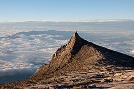
A smaller peak of Mount Kinabalu.
-
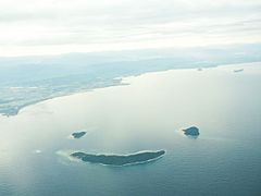
The beautiful islands of Manukan, Mamutik, and Sulug.
-
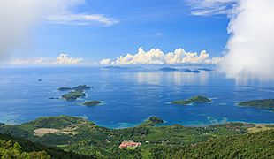
A panoramic sea view from Lahad Datu District.
-
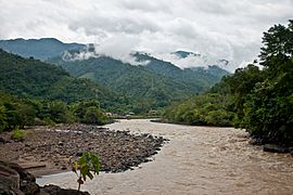
The scenic Padas River Valley.


Sabah's Amazing Biodiversity
.jpg)
Sabah's jungles are home to a huge variety of plants and animals. Most of Sabah's amazing wildlife lives in forest reserve areas. These reserves make up half of Sabah's total land area. They are part of the "Heart of Borneo" project, which protects 20 million hectares of rainforest.
The forests around the Kinabatangan River form the largest forest-covered floodplain in Malaysia. The Crocker Range National Park is the biggest national park in Sabah. It covers 139,919 hectares (345,747 acres). Most of the park is dense forest. It is important for collecting water, as its headwaters feed five major rivers on the west coast.
Kinabalu National Park was named a World Heritage Site by UNESCO in 2000. This is because it has so many different plants and unique land features. The park has over 4,500 species of plants and animals. This includes 326 bird species, about 100 mammal species, and over 110 land snail species.

Tiga Island was formed by a mud volcano eruption in 1897. Today, it is part of the Tiga Island National Park. This park also includes Kalampunian Besar and Kalampunian Damit islands. Tourists visit for the mud baths.
The Tunku Abdul Rahman National Park is a group of five islands: Gaya, Manukan, Mamutik, Sapi, and Sulug. These islands were once connected to the Crocker Range. They became separate when sea levels rose after the last ice age.
The Tun Mustapha Marine Park is the largest marine park in northern Sabah. It includes the three main islands of Banggi, Balambangan, and Malawali. Another marine park is the Tun Sakaran Marine Park in southeastern Sabah. This park has the islands of Bodgaya, Boheydulang, Sabangkat, and Salakan. It also has sand cays like Maiga, Mantabuan, and Sibuan. Bodgaya is a forest reserve, and Boheydulang is a bird sanctuary. These islands were formed by volcanic activity.
The Tawau Hills National Park was created to protect a natural water catchment area. The park has rugged volcanic landscapes, including a hot spring and beautiful waterfalls. The Turtle Islands National Park borders the Philippine Turtle Islands. It has three islands: Selingaan, Bakkungan Kechil, and Gulisaan. These islands are famous nesting sites for green turtles and hawksbill sea turtles.
Other important wildlife areas in Sabah include the Maliau Basin, Danum Valley, Tabin, Imbak Canyon, and Sepilok. These places are protected as national parks, wildlife reserves, or forest reserves. Off the coast of Sabah, there are many islands with rich coral reefs. These include Ligitan, Sipadan, Selingaan, Tiga, and Layang-Layang (Swallow Reef). Other main islands are Jambongan, Timbun Mata, Bum Bum, and the divided Sebatik.
The Sabah state government has laws to protect its forests and endangered wildlife. These laws include the Animals Ordinance 1962, Forest Enactment 1968, and the Wildlife Conservation Enactment 1997. Under the Wildlife Conservation Enactment, hunting in protected areas can lead to five years in prison and a fine of RM50,000. The government also plans to allow seasonal hunting. This is part of its efforts to protect endangered species while keeping local hunting traditions.
Images for kids
-
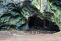
Entrance to the Madai Cave.
-
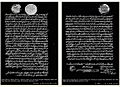
Left: The first agreement signed by Sultan Abdul Momin of Brunei in 1877. Right: The second agreement signed by Sultan Jamal ul-Azam of Sulu in 1878.
-
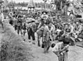
Japanese civilians and soldiers before leaving for Jesselton after surrendering to the Australian Imperial Force (AIF) in Tawau in 1945.
-

Donald Stephens (left) announcing the formation of Malaysia at Merdeka Square, Jesselton in 1963. With him are Tun Abdul Razak (right) and Mustapha Harun (second right).
-
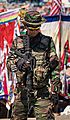
A Malaysian Army soldier with an Colt M4 guarding Sabah's east coast as part of the Eastern Sabah Security Command (ESSCOM).
-
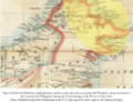
Map of British North Borneo showing the area claimed by the Philippines.
-
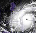
Sabah is south of the typhoon belt, so it is usually safe from strong typhoons like Typhoon Haiyan in 2013.
-
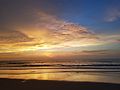
Sunset over the shorelines of Sabah.
-
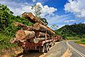
A lorry carrying timber in Tawau. Logging has brought in over 50% of the state's income.
-
An aerial view of Mamut Mine filled with water. This water is unsafe to drink due to high levels of heavy metals.
-
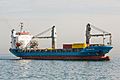
A Container ship passing through Likas Bay in the South China Sea.
-
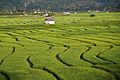
A Paddy field in Tambunan District.
-
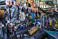
Fishing activities in the harbour of Sandakan.
-
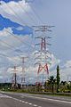
A high voltage electricity pylon near the Kimanis Power Plant.
-
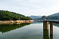
Babagon Dam, the largest water storage area in the state.
-
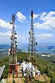
Telecommunication towers on Mount Silam overlooking Darvel Bay of Lahad Datu.
-
An advertisement for radio stations like Era FM, My FM, and Hitz FM in Kota Kinabalu.
-
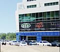
The building of Sabah Broadcasting Complex in Donggongon.
-
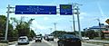
An eight-lane highway in Kota Kinabalu, part of the Pan-Borneo Highway.
-
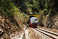
A Sabah State Railway train going through a tunnel on the Western Line in Pengalat Besar, Papar District.
-
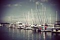
Boats and ferries at the Kota Kinabalu marina.
-
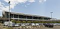
Kota Kinabalu International Airport (Terminal 1).
-
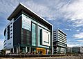
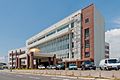
Gleneagles Kota Kinabalu, a major private hospital in Sabah.
-
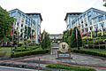
Universiti Malaysia Sabah (UMS) chancellery building.
-
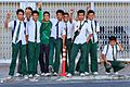
Sabahan secondary school students in their uniform.
-
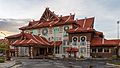
The branch building of the National Department for Culture and Arts in Kota Kinabalu.
-
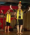
The Sumazau dance performance by Papar Kadazan people at the Monsopiad Cultural Village.
-
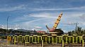
The roundabout in Tambunan with a sculpture of the Sompoton, Sabah's main musical instrument.
-

A swordfish hinava served with sandwich bread.
-
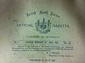
A page from the British North Borneo Official Gazette from 1902.
-

Three Came Home, a 1950 Hollywood film based on Agnes Newton Keith's life in Sandakan during World War II.
-

The Borneo Bug Fest in 2016, featuring Volkswagen Beetle cars.
-

The Borneo International Marathon in 2015.
-
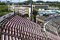
Likas Stadium, the home stadium for Sabah FA.
-
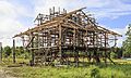
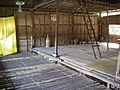
A traditional house being built.
-
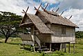
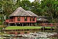
A Bajau house.
-
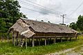
A Bisaya house.
-
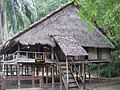
A Brunei Malay house.
-
A Dusun longhouse.
-
An Illanun house.
-
A Lotud house.

_Sulu_(right)_Overbeck.jpg)
.JPG)
.jpg)
.jpg)


See also
 In Spanish: Sabah para niños
