Russell Glacier (Mount Rainier) facts for kids
Quick facts for kids Russell Glacier |
|
|---|---|

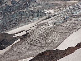
Ablation zone of Russell Glacier with Carbon Glacier behind
|
|
| Type | Mountain glacier |
| Location | Mount Rainier, Pierce County, Washington, USA |
| Coordinates | 46°53′52″N 121°47′20″W / 46.89778°N 121.78889°W |
| Area | 1.3 square miles (3.4 km2), 1983 |
The Russell Glacier is a medium-sized glacier found on the north side of Mount Rainier in Washington. It was named after a geologist named Israel Russell. This glacier covers about 1.3 square miles (3.4 km2) of land. It holds a huge amount of ice, around 3.1 billion cubic feet (88 million cubic meters)!
Contents
Russell Glacier: A Giant Ice River
A glacier is like a very slow-moving river made of ice. The Russell Glacier starts high up on Mount Rainier, at about 9,400 feet (2,900 m). From there, it slowly flows northeast. It moves towards another, even bigger glacier called the Carbon Glacier.
How Russell Glacier Flows
The Russell Glacier actually adds some of its ice to the Carbon Glacier. This happens before the Russell Glacier becomes a separate ice mass again, below 7,000 feet (2,100 m). Most of the ice in the Russell Glacier is found between 8,000 feet (2,400 m) and 9,000 feet (2,700 m) in elevation.
Unlike the Carbon Glacier, which reaches much lower elevations, the Russell Glacier only goes down to about 6,800 feet (2,100 m). This means it stays higher up on the mountain.
Nearby Mountain Features
Close to the Russell Glacier, you can find two smaller peaks of Mount Rainier. These are called Echo Rock and Observation Rock. Observation Rock is about 8,364 ft (2,549 m) tall. Both of these rocky areas are located northwest of the glacier.
Where Does the Meltwater Go?
As the glacier slowly melts, the water flows away. This meltwater from the Russell Glacier eventually reaches the Carbon River. This river then carries the water further away from the mountain.

