Saale-Holzland Rural District facts for kids
Quick facts for kids
Saale-Holzland-Kreis
|
|
|---|---|
 |
|
| Country | |
| State | Thuringia |
| Capital | Eisenberg |
| Area | |
| • Total | 817 km2 (315 sq mi) |
| Population
(2002)
|
|
| • Total | 92,969 |
| • Density | 113.79/km2 (294.72/sq mi) |
| Time zone | UTC+1 (CET) |
| • Summer (DST) | UTC+2 (CEST) |
| Vehicle registration | SHK |
| Website | http://www.saale-holzland-kreis.de |
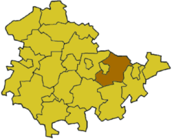
Saale-Holzland-Kreis is a special area in Thuringia, Germany. It is like a county or a rural district. Its main town, or capital, is Eisenberg. This district is located in the eastern part of Thuringia.
History of Saale-Holzland-Kreis
The Saale-Holzland-Kreis was created in 1994. It was formed by joining three older districts. These were the districts of Eisenberg, Jena, and Stadtroda.
The Stadtroda district was first set up in 1922. It covered almost the same area as the current district. Later, in 1952, the government in East Germany made some changes. They got rid of the old federal states. They also split the Stadtroda district into three smaller parts. These three parts were then put back together in 1994 to form the Saale-Holzland-Kreis we know today.
What the Coat of Arms Means
 |
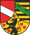
The coat of arms is like a special symbol for the district. On the left side, you can see a silver bar. This bar represents the Lords of Lobdeburg. They owned the Saale valley in the 13th century.
At the bottom of the shield, there is a lion. This lion belongs to the Counts of Orlamünde. It is surrounded by six hearts. Their land became part of the House of Wettin family in 1396. On the right side, you see the coat of arms of Saxony. This is the same as the Wettin family's coat of arms. The Wettin family later became the rulers of Saxony. The district was given this coat of arms on August 18, 1997. |
Towns and Communities
Saale-Holzland-Kreis has many towns and smaller communities. Some towns manage themselves. Others are part of a group called a Verwaltungsgemeinschaft. This is like a shared office for several smaller towns and villages. They work together on things like local services.
Here are some of the main towns in the district:
- Bürgel
- Eisenberg (the capital)
- Kahla
- Stadtroda
And here are a few examples of other communities:
- Bad Klosterlausnitz
- Gösen
- Hainspitz
There are also several Verwaltungsgemeinschaften in the district. These are groups of smaller towns and villages that share administrative tasks. For example, the Verwaltungsgemeinschaft of Dornburg-Camburg includes towns like Camburg and Dornburg. Another one is Hermsdorf, which includes the town of Hermsdorf. These groups help the smaller places work together efficiently.
 | Emma Amos |
 | Edward Mitchell Bannister |
 | Larry D. Alexander |
 | Ernie Barnes |

