Saddle Ball Mountain facts for kids
Quick facts for kids Saddle Ball Mountain |
|
|---|---|
| Highest point | |
| Elevation | 3,238 ft (987 m) |
| Prominence | 207 ft (63 m) |
| Geography | |
| Location | Berkshire County, Massachusetts |
| Parent range | Greylock Range |
Saddle Ball Mountain is a tall peak located in Berkshire County, Massachusetts. It is the second highest mountain in the state of Massachusetts.
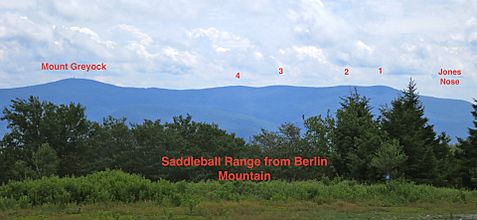
Saddle Ball Mountain is one of several bumps or smaller peaks along the southern ridge of the Mount Greylock mountain range. The famous Appalachian Trail (AT) runs along this ridge, heading north towards the very top of Mount Greylock. The highest point of Saddle Ball Mountain is found along the Appalachian Trail, a short distance north of where it meets the Jones Nose Trail.
Contents
Mountain Names and History
Long ago, in the 1700s, Mount Greylock was known by English settlers as Grand Hoosuc(k). Later, in the early 1800s, Mount Greylock was often called Saddleback Mountain. This was because it looked like a saddle when viewed from the south. In this view, Saddle Ball Mountain forms the back part of the saddle, and Mount Greylock forms the front part.
Saddle Ball Mountain itself used to be called Mount Griffin in the early 1800s. By the mid-1800s, people decided to call the main peak Mount Greylock. The name Saddle Ball Mountain stayed to remind people of Greylock's earlier name.
Finding the Highest Point
There has been some discussion about the exact highest point of Saddle Ball Mountain. Different maps and surveys have shown slightly different locations:
- A 1988 map showed Saddle Ball Mountain at 3,235 feet (986 meters).
- A 1989 map showed it at 3,238 feet (987 meters).
- A 2012 trail map showed it at 3,247 feet.
However, in 2013, groups using GPS and altimeters (tools to measure height) found that the southernmost peak of Saddle Ball Mountain is the highest. A small pile of rocks, called a cairn, on the west side of the Appalachian Trail is very close to, or might even be, the true highest point.
How the Mountain Was Formed
Saddle Ball Mountain and Mount Greylock are mostly made of a type of rock called phyllite. This is a metamorphic rock, meaning it changed from another type of rock due to heat and pressure. Underneath this, there are younger layers of other changed rocks, like marble.
These mountains were formed by a process called "thrust-faulting." This is a tectonic process where older rocks are pushed up and over younger rocks during times when huge forces are building mountains.
Where the Mountain Is
Saddle Ball Mountain and Mount Greylock are part of a mountain range that is about 11 miles long and 4.5 miles wide. It runs north to south, like an island surrounded by other mountain ranges. To the east is the Hoosac Range, to the north are the Green Mountains, and to the west are the Taconic Mountains.
About 18,000 years ago, during the Pleistocene Ice Age, huge ice sheets (like giant glaciers) covered Mount Greylock and nearby peaks. These ice sheets were up to 1 kilometer (about 0.6 miles) thick! As the ice melted and moved back, the Greylock Range became like an island in the middle of a large lake called Lake Bascom.
Forests and Wildlife
Along the top of the Greylock mountain range, above 3,000 feet, you can find a special type of forest. This is called a subalpine forest, or taiga-boreal forest. It's the only place in Massachusetts where this kind of forest grows, usually found in much colder, northern areas.
The Mount Greylock range is also known as an important bird area. This means it's a very important place for birds. Many bird species that usually breed in colder, northern forests, like the blackpoll warbler and Bicknell's thrush, come to breed in the high-altitude forests of Mount Greylock.
Fun Activities and Trails
If you are a hiker heading north on the Appalachian Trail or the Jones Nose Trail, you will walk over the southernmost and highest part of Saddle Ball Mountain. This is about 0.2 to 0.3 miles north of where the AT and Jones Nose Trail meet. The highest point is near a small cairn (a pile of stones) on the west side of the Appalachian Trail.
The two northernmost peaks of Saddle Ball Mountain are a bit harder to reach. They require a short but tough hike off the main trail, through the trees, to find their forested high points.
 | Bayard Rustin |
 | Jeannette Carter |
 | Jeremiah A. Brown |


