
Saint-Étienne-de-Lugdarès facts for kids
Quick facts for kids
Saint-Étienne-de-Lugdarès
|
||
|---|---|---|
 |
||
|
||

Saint-Étienne-de-Lugdarès
Location in France

Saint-Étienne-de-Lugdarès
Location in Auvergne-Rhône-Alpes
|
||
| Country | France | |
| Region | Auvergne-Rhône-Alpes | |
| Department | Ardèche | |
| Arrondissement | Largentière | |
| Canton | Saint-Étienne-de-Lugdarès | |
| Intercommunality | Cévenne et Montagne Ardéchoise | |
| Area
1
|
50.34 km2 (19.44 sq mi) | |
| Population
(1999)
|
458 | |
| • Density | 9.098/km2 (23.564/sq mi) | |
| Time zone | UTC+01:00 (CET) | |
| • Summer (DST) | UTC+02:00 (CEST) | |
| INSEE/Postal code |
07232 /07590
|
|
| Elevation | 969–1,485 m (3,179–4,872 ft) (avg. 1,033 m or 3,389 ft) |
|
| 1 French Land Register data, which excludes lakes, ponds, glaciers > 1 km2 (0.386 sq mi or 247 acres) and river estuaries. | ||

Saint-Étienne-de-Lugdarès is a small and charming commune (which is like a town or village) located in the Ardèche département in southern France. It's a place where you can find beautiful natural landscapes and a peaceful way of life.
Contents
What is Saint-Étienne-de-Lugdarès?
Saint-Étienne-de-Lugdarès is a commune in the Ardèche region of France. It is known for its stunning natural beauty, including mountains and green valleys. The village is nestled in the heart of the Massif Central mountain range.
Where is Saint-Étienne-de-Lugdarès located?
This commune is found in the southern part of France. It's part of the Ardèche département, which is like a county or administrative area. The area is famous for its rugged landscapes and outdoor activities.
How big is Saint-Étienne-de-Lugdarès?
The commune covers an area of about 50.34 square kilometers. In 1999, its population was 458 people. This makes it a small community, perfect for those who enjoy quiet surroundings.
Who manages Saint-Étienne-de-Lugdarès?
Like all communes in France, Saint-Étienne-de-Lugdarès has a mayor who leads the local government. The mayor helps manage the daily life of the village.
Who is the mayor?
From 2001 to 2008, the mayor of Saint-Étienne-de-Lugdarès was Marc Champel. The mayor works to make sure the commune runs smoothly for its residents. They are responsible for local services and projects.
What is an intercommunality?
Saint-Étienne-de-Lugdarès is part of an "intercommunality" called Cévenne et Montagne Ardéchoise. This means it works together with other nearby communes. They share resources and work on projects that benefit all the communities in the area.
What is the geography like?
The commune is located in a mountainous region. Its elevation ranges from 969 meters to 1485 meters above sea level. The average elevation is 1033 meters. This high elevation means it has cool temperatures and beautiful views.
What are the coordinates?
The exact location of Saint-Étienne-de-Lugdarès can be found using its coordinates: 44.6525 degrees North latitude and 3.95638888889 degrees East longitude. These numbers help pinpoint its spot on a map.
Images for kids
-
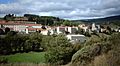
A view of Saint-Étienne-de-Lugdarès in Ardèche, France.
-
The coat of arms for the region.
See also
 In Spanish: Saint-Étienne-de-Lugdarès para niños

