Saint Petersburg Governorate facts for kids
Quick facts for kids
Saint Petersburg Governorate
Санкт-Петербургская губерния
|
||
|---|---|---|
|
Governorate
|
||
|
||
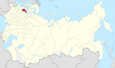
Location in the Russian Empire
|
||
| Country | Russian Empire | |
| Established | 1708 | |
| Abolished | 1927 | |
| Capital |
|
|
| Area | ||
| • Total | 44,613 km2 (17,225 sq mi) | |
| Population
(1897)
|
||
| • Total | 2,112,033 | |
| • Density | 47.3412/km2 (122.6131/sq mi) | |
| • Urban | 67.32% | |
| • Rural | 32.68% | |
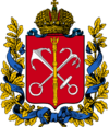
The Saint Petersburg Governorate was a large region, like a province, in the Russian Empire. Its capital city was Saint Petersburg. This area covered about 44,613 square kilometers and was home to over 2.1 million people in 1897.
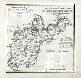
It shared borders with other important regions. To the west were the Estonian and Livonian Governorates. To the south was the Pskov Governorate, and to the east, the Novgorod Governorate. The Olonets Governorate was to the northeast, and the Vyborg Governorate of Finland was to the north. Today, this area mostly covers the Leningrad Oblast in Russia and parts of several counties in Estonia.
Contents
How it Started
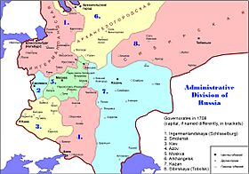
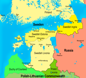
The story of the Saint Petersburg Governorate began with the Ingermanland Governorate. This region was created from lands that Russia won back from the Swedish Empire during the Great Northern War.
In 1704, Prince Alexander Menshikov became its first governor. By 1706, it was officially called a "Governorate," making it one of Russia's first such regions. On December 18, 1708, Tsar Peter the Great decided to divide all of Russia into eight Governorates. The Ingermanland Governorate grew even bigger, including cities like Pskov and Novgorod. At first, the exact borders of these Governorates were not very clear. Instead, they were defined by the cities they included and the lands around them.
On June 3, 1710, the Ingermanland Governorate got a new name: the Saint Petersburg Governorate. This was named after the new city of Saint Petersburg, which was becoming very important. In 1721, more land from Sweden, including parts of Ingria, was officially given to Russia by the Treaty of Nystad. Later, after another treaty in 1743, some of these new lands became part of a separate region called the Governorate of Vyborg.
The name of the Governorate changed a few more times. From 1914 to 1924, it was called the Petrograd Governorate. Then, from 1924 to 1927, it was known as the Leningrad Governorate. Finally, on August 1, 1927, it was officially ended. A new region, the modern Leningrad Oblast, was created in its place.
Cities in the First Governorate
When the Ingermanland Governorate was first set up, it included many important cities. Here are some of them:
| # | City | # | City | # | City |
|---|---|---|---|---|---|
| 1. | St. Petersburg | 12. | Narva | 23. | Staraya Rusa |
| 2. | Beloozero | 13. | Olonets | 24. | Toropets |
| 3. | Bezhetskoy Verkh | 14. | Opochek | 25. | Torzhok |
| 4. | Derptskoy uyezd | 15. | Ostrov | 26. | Tver |
| 5. | Gdov | 16. | Porkhov | 27. | Uglich |
| 6. | Izborsk | 17. | Poshekhonye | 28. | Ustyuzhna Zheleznopolskaya |
| 7. | Kargopol | 18. | Pskov | 29. | Veliky Novgorod |
| 8. | Kashin | 19. | Romanov | 30. | Yamburg |
| 9. | Koporye | 20. | Rzheva pustaya (Zavolochye) | 31. | Yaroslavl |
| 10. | Ladoga | 21. | Rzheva Volodimirova | ||
| 11. | Luki Velikiye | 22. | Shlisselburg |
Administrative Divisions
By January 1, 1914, the Saint Petersburg Governorate was divided into eight smaller areas called counties (uezds). Each county had its own main town. The table below shows these counties, their main towns, and how many people lived there in 1897.
| County | County Town | Arms of County Town | Area | Population (1897 census) |
|
|---|---|---|---|---|---|
| Transliteration name | Russian Cyrillic | ||||
| Gdovsky | Гдовский | Gdov | 8,810 km2 (3,400 sq mi) |
145,573 | |
| Luzhsky | Лужский | Luga | 10,192.7 km2 (3,935.4 sq mi) |
133,466 | |
| Novoladozhsky | Новоладожский | Novaya Ladoga | 8,707.4 km2 (3,361.9 sq mi) |
87,841 | |
| Petergofsky | Петергофский | Petergof | 2,742.5 km2 (1,058.9 sq mi) |
140,547 | |
| Sankt-Peterburgsky | Санкт-Петербургский | Saint Petersburg (Sankt–Peterburg) |
1,973.8 km2 (762.1 sq mi) |
1,317,885 | |
| Tsarskoselsky | Царскосельский | Tsarskoye Selo | 4,303.9 km2 (1,661.7 sq mi) |
149,845 | |
| Shlisselburgsky | Шлиссельбургский | Shlisselburg | 3,870.7 km2 (1,494.5 sq mi) |
54,904 | |
| Yamburgsky | Ямбургский | Yamburg | 4,014.4 km2 (1,550.0 sq mi) |
81,972 | |
Other Important Towns
Besides the main county towns, there were other significant cities within the Governorate. Some of these were very populated and had their own unique features.
| City | Population | Part of | Arms |
|---|---|---|---|
| Gatchina | 14,824 | Tsarskoselsky Uyezd | |
| Kronstadt | 59,525 | Petergofsky Uyezd | |
| Narva | 16,599 | Yamburgsky Uyezd | |
| Oranienbaum | 5,458 | Petergofsky Uyezd | |
| Pavlovsk | 5,113 | Tsarskoselsky Uyezd |
Towns That No Longer Exist
Some towns that were once part of the Governorate are not around anymore, or they have changed significantly.
| City | Population | Part of | Arms |
|---|---|---|---|
| Rozhdestveno | 980 | Tsarskoselsky Uyezd | |
| Sofia | 1,190 |
See also
- Administrative divisions of Russia in 1708–1710
 | Mary Eliza Mahoney |
 | Susie King Taylor |
 | Ida Gray |
 | Eliza Ann Grier |


