Samuel S. Lewis State Park facts for kids
Quick facts for kids Samuel S. Lewis State Park |
|
|---|---|
|
IUCN Category III (Natural Monument)
|
|

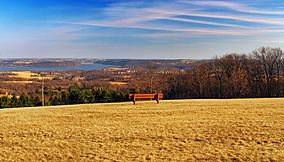
South-to-southeast view of the Susquehanna River Valley, Samuel S. Lewis State Park.
|
|
| Location | Lower Windsor Township, York, Pennsylvania, United States |
| Area | 85 acres (34 ha) |
| Elevation | 689 ft (210 m) |
| Established | 1954 |
| Named for | Samuel S. Lewis |
| Governing body | Pennsylvania Department of Conservation and Natural Resources |
| Website | Samuel S. Lewis State Park |
Samuel S. Lewis State Park is a fun place to visit in Pennsylvania. It is an 85-acre state park located in Lower Windsor Township, York County. The park's main feature is Mt. Pisgah, a ridge that is about 885 feet high.
From Mt. Pisgah, you can see amazing views of the Susquehanna River Valley. The park is about 12 miles (19 km) east of York, close to U.S. Highway 30. It's a great spot for outdoor activities and enjoying nature.
Contents
Park History: How It Started
Samuel S. Lewis State Park was created from four different pieces of land. The park is named after Samuel S. Lewis. He generously donated his 35-acre farm to Pennsylvania in 1954.
In the same year, Walter Stein sold his 1-acre arboretum (a garden for trees) to the state. The state also bought 15 acres from the Almoney Farm. These three pieces formed the first part of the park. Later, in 1999, the state added another 14 acres, making the park what it is today.
Fun Activities at the Park
Samuel S. Lewis State Park offers many cool things to do! You can have a picnic at one of the tables. These are available first-come, first-served. There are also three pavilions you can reserve for a day of fun.
If you like hiking, there's a one-mile (1.6 km) trail. It goes through a beautiful pine forest and passes by interesting rock formations. The top of Mt. Pisgah is perfect for kite flying. Kite flying clubs often meet here to practice. They even help beginners learn how to fly kites!
Amazing Views and Stargazing
Mt. Pisgah is the highest point in the area. From the top, you get a fantastic view of the towns and fields around you. You can also see the wide Susquehanna River.
This spot is very popular for looking at the stars. Astronomy clubs often hold special events here to watch the night sky. The summit of Mt. Pisgah is also a favorite place for weddings because of its beautiful scenery.
Other Parks Nearby
Here are some other state parks not too far from Samuel S. Lewis State Park (within 30 miles):
- Codorus State Park (York County)
- Gifford Pinchot State Park (York County)
- Gunpowder Falls State Park (Maryland)
- Rocks State Park (Maryland)
- Susquehannock State Park (Lancaster County)
 | Misty Copeland |
 | Raven Wilkinson |
 | Debra Austin |
 | Aesha Ash |


