San Juan Ixcoy facts for kids
Quick facts for kids
San Juan Ixcoy
Yich Kʼox
|
|
|---|---|
|
Municipality
|
|
| Country | |
| Department | |
| Municipality | San Juan Ixcoy |
| Government | |
| • Type | Municipal |
| Area | |
| • Municipality | 224 km2 (86 sq mi) |
| Highest elevation | 2,000 m (7,000 ft) |
| Lowest elevation | 1,500 m (4,900 ft) |
| Population
(Census 2002)
|
|
| • Municipality | 19,367 |
| • Urban | 2,185 |
| • Ethnicities | Q'anjob'al (90%) Mam (7%) Akatek (2%) Ladino (1%) |
| • Religions | Roman Catholicism Evangelicalism Maya |
| Climate | Cwb |
| Website | Municipal site |
San Juan Ixcoy is a town and area in Guatemala. It's also known as Yich Kʼox in the Qʼanjobʼal language. It's part of the Huehuetenango region. This area covers about 224 square kilometers. It includes the main town of San Juan Ixcoy, plus 11 villages and 33 smaller rural communities called caserios. Most of the 19,367 people living here (as of 2002) are Maya from the Q'anjob'al group.
Contents
About San Juan Ixcoy
San Juan Ixcoy is located in the Sierra de los Cuchumatanes mountains. It shares borders with other towns. To the north are Soloma and Santa Eulalia. Chiantla is to the south, and Nebaj is to the east.
Getting Around
You can reach San Juan Ixcoy directly by road using RN-9-N. There are no train lines nearby. The closest airport is in Quetzaltenango. For international flights, people use La Aurora International Airport.
What People Do
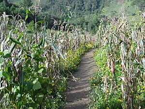
Most families in San Juan Ixcoy rely on farming. This means they grow food mainly for themselves and their families. They often grow maize (corn), beans, and a type of squash called ayote. They also grow potatoes and wheat.
Local Crafts
People also make money by creating handmade textiles and traditional crafts. These items add to their family income.
Working Away From Home
Sometimes, people travel to find work. They might go to large farms on the southern coast of Guatemala. Some even travel to the United States for work.
See also
 In Spanish: San Juan Ixcoy para niños
 | Charles R. Drew |
 | Benjamin Banneker |
 | Jane C. Wright |
 | Roger Arliner Young |


