Chiantla facts for kids
Quick facts for kids
Chiantla
|
|
|---|---|
|
Municipality
|
|

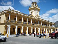
Chiantla Municipal Palace
|
|
| Country | |
| Department | |
| Municipality | Chiantla |
| Government | |
| • Type | Municipal |
| Area | |
| • Municipality | 521 km2 (201 sq mi) |
| Elevation | 2,000 m (7,000 ft) |
| Highest elevation | 3,800 m (12,500 ft) |
| Lowest elevation | 1,900 m (6,200 ft) |
| Population
(2018 census)
|
|
| • Municipality | 87,447 |
| • Density | 167.84/km2 (434.7/sq mi) |
| • Urban | 7,208 |
| • Ethnicities | Ladino Mam |
| • Religions | Roman Catholicism Evangelicalism Maya |
| Climate | Cwb |
| Website | http://www.inforpressca.com/chiantla/ |
Chiantla (Spanish pronunciation: [ˈtʃjantla]) is a town and municipality in the Guatemalan department of Huehuetenango. It sits high up, about 2,000 meters (6,560 feet) above sea level. The area it covers is 521 square kilometers (201 square miles). Every year, Chiantla celebrates its main festival on January 28.
Contents
History of Chiantla
Early Days and Spanish Influence
After the Spanish conquest of Guatemala in the 1520s, a religious group called the Mercedarians arrived. They formed a special area called the "Presentación de Guatemala" province in 1565. At first, they had churches and missions near the capital city.
Later, the Mercedarians traded these areas with another religious group, the Order of Preachers. This trade gave the Mercedarians control over areas in the Sierra de los Cuchumatanes mountains. By the early 1600s, they also had missions in four towns close to the capital. These towns eventually became neighborhoods of the city.
Mercedarian Missions and Changes
According to old records from 1613 and 1770, the Mercedarians managed nine main missions. They also had many smaller attached areas. Some of these missions were in places like Concepción de Huehuetenango and San Pedro de Solomá. One important mission was Nuestra Señora de la Candelaria de Chiantla.
However, in 1754, big changes came from the Spanish kings. These changes were part of the "Borbon reforms." Because of these reforms, the Mercedarians and other religious orders had to give up their missions. They transferred them to the "secular clergy," who were priests not part of a specific religious order. This meant the Mercedarians lost their convent and missions in Chiantla.
What is the Climate Like in Chiantla?
Chiantla is located about 2,000 meters (6,560 feet) above sea level. This high altitude makes its climate similar to that of Antigua, but it's often a bit cooler at night. Chiantla has a subtropical highland climate, which means it has mild temperatures all year.
The rainy season in Chiantla lasts from May to October. During these months, mornings are usually warm and humid. Then, heavy rains, and sometimes even hail, fall in the afternoons. The weather usually clears up by evening.
| Climate data for Chiantla | |||||||||||||
|---|---|---|---|---|---|---|---|---|---|---|---|---|---|
| Month | Jan | Feb | Mar | Apr | May | Jun | Jul | Aug | Sep | Oct | Nov | Dec | Year |
| Mean daily maximum °C (°F) | 21.3 (70.3) |
22.5 (72.5) |
24.7 (76.5) |
25.2 (77.4) |
24.4 (75.9) |
23.0 (73.4) |
22.7 (72.9) |
23.2 (73.8) |
22.8 (73.0) |
21.9 (71.4) |
21.7 (71.1) |
21.2 (70.2) |
22.9 (73.2) |
| Daily mean °C (°F) | 14.6 (58.3) |
15.3 (59.5) |
17.3 (63.1) |
18.1 (64.6) |
18.2 (64.8) |
17.7 (63.9) |
17.2 (63.0) |
17.1 (62.8) |
17.2 (63.0) |
16.5 (61.7) |
15.5 (59.9) |
14.8 (58.6) |
16.6 (61.9) |
| Mean daily minimum °C (°F) | 7.9 (46.2) |
8.1 (46.6) |
9.9 (49.8) |
11.0 (51.8) |
12.1 (53.8) |
12.4 (54.3) |
11.7 (53.1) |
11.1 (52.0) |
11.6 (52.9) |
11.1 (52.0) |
9.4 (48.9) |
8.5 (47.3) |
10.4 (50.7) |
| Average precipitation mm (inches) | 11 (0.4) |
11 (0.4) |
24 (0.9) |
47 (1.9) |
112 (4.4) |
224 (8.8) |
140 (5.5) |
139 (5.5) |
203 (8.0) |
150 (5.9) |
38 (1.5) |
11 (0.4) |
1,110 (43.6) |
| Source: Climate-Data.org | |||||||||||||
Who Lives in Chiantla?
Most people living in Chiantla are Ladino. However, it's very common to hear other languages spoken by people in the streets. These languages include Popti, Canjobal, Chuj, and Mam. Many street vendors, shoppers, and residents speak these different languages.
What is Chiantla's Economy Like?
Mining in Chiantla
Mining has been important in the Chiantla area for a long time. Records show that Lead was produced here as early as 1850. Today, companies are still exploring for valuable minerals.
A Canadian company called Firestone Ventures is looking into the Chiantla mining district. They have found a promising spot for a mine called the Torlon Hill Zinc-Lead-Silver Project. This project is west of Chiantla and could be an open pit mine. This means minerals like lead, zinc, and silver would be dug up from the surface.
- See photos of the Torlon Hill Zinc project
Where is Chiantla Located?
Chiantla is almost completely surrounded by other towns in the Huehuetenango Department. The city of Chiantla itself is in the northwest part of the Huehuetenango region. It sits in the mountains above the city of Huehuetenango. It is also about a two-hour drive from the border with Mexico.
 |
San Juan Ixcoy |  |
||
| San Sebastián Huehuetenango and Todos Santos Cuchumatán | Aguacatán Nebaj, Quiché Department municipality |
|||
| Huehuetenango. |
Images for kids
-
Mercedarian coat of arms.
See also
 In Spanish: Chiantla para niños
 | Roy Wilkins |
 | John Lewis |
 | Linda Carol Brown |


