San Martín Region facts for kids
Quick facts for kids
San Martín Region
|
|||
|---|---|---|---|
|
|||

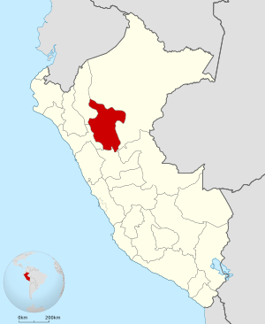
Location of the San Martín Region in Peru
|
|||
| Country | Peru | ||
| Subdivisions | 10 provinces and 77 districts | ||
| Largest city | Tarapoto | ||
| Capital | Moyobamba | ||
| Area | |||
| • Total | 51,253.31 km2 (19,789.01 sq mi) | ||
| Highest elevation | 3,080 m (10,100 ft) | ||
| Lowest elevation | 190 m (620 ft) | ||
| Population
(2017)
|
|||
| • Total | 813,381 | ||
| • Density | 15.869824/km2 (41.102655/sq mi) | ||
| UBIGEO |
22
|
||
| Dialing code | 042 | ||
| ISO 3166 code | PE-SAM | ||
| Principal resources | Coffee, rice, yucca, cocoa, tobacco, cebu cattle. | ||
| Poverty rate | 62.4% | ||
| Percentage of Peru's GDP | 1.85% | ||
| Website | www.regionsanmartin.gob.pe | ||
The San Martín Region is a special area in northern Peru. Most of this region is located in the upper part of the famous Amazon rainforest. It's a place full of nature and interesting cities.
The capital city of San Martín is Moyobamba. However, the largest and busiest city in the region is Tarapoto.
Contents
Welcome to San Martín!
San Martín is one of the 25 regions that make up the country of Peru. It is known for its beautiful landscapes. These include lush forests, winding rivers, and green mountains. The region offers a mix of adventure and natural beauty.
Where is San Martín?
This region is found in the northern part of Peru. It sits mostly within the Amazon basin. This means it has a warm, humid climate. The region covers a large area of about 51,253 square kilometers. That's roughly the size of a small country!
San Martín is bordered by other Peruvian regions. These include Loreto Region to the north and east. To the south, it borders Huánuco Region and Ucayali Region. To the west, it borders La Libertad Region and Amazonas Region.
What's San Martín Like?
The land in San Martín varies a lot. You can find high mountains and deep valleys. There are also flat areas covered by rainforest. The highest point in the region is about 3,080 meters above sea level. The lowest point is around 190 meters.
The climate is mostly tropical. This means it's warm all year round. There is also a lot of rain, especially during certain months. This rainfall helps the rainforest grow thick and green. It supports many different plants and animals.
People and Cities
As of 2017, about 813,381 people live in the San Martín Region. The region is divided into 10 provinces. These provinces are then split into 77 districts. This helps manage the different areas.
Moyobamba is the official capital. It is often called the "City of Orchids" because of its many beautiful flowers. Tarapoto is the largest city. It is a popular spot for tourists. Many people visit to see the waterfalls and explore the jungle.
What Grows Here?
The San Martín Region is very important for Peru's agriculture. Farmers here grow many different crops. These crops are a big part of the region's economy.
Some of the main products include:
- Coffee: San Martín is a major coffee-producing area.
- Rice: This is a staple food and widely grown.
- Yucca: Also known as cassava, it's a root vegetable.
- Cocoa: Used to make chocolate, it's an important crop.
- Tobacco: Another significant agricultural product.
- Cebu cattle: These animals are raised for meat and milk.
These products help support the people living in San Martín. They also contribute to Peru's overall economy.
Who Leads San Martín?
Like other regions in Peru, San Martín has its own government. This government helps manage the region's services. It also works on projects to improve life for its citizens.
The leader of the region is called the Governor. From 2019 to 2022, the Governor was Pedro Bogarín Vargas. The regional government works to develop the area. They focus on things like education, health, and infrastructure.
See also
 In Spanish: Departamento de San Martín para niños
 | Aurelia Browder |
 | Nannie Helen Burroughs |
 | Michelle Alexander |


