
Sandin, Zamora facts for kids
Quick facts for kids
Sandin
|
|||
|---|---|---|---|
|
|||

Sandin, Zamora
Location in Spain
|
|||
| Country | |||
| Autonomous community | |||
| Province | |||
| Comarca | La Carballeda | ||
| Municipality | Manzanal de Arriba | ||
| Elevation | 716 m (2,349 ft) | ||
| Population
(2020 INE)
|
|||
| • Total | 33 | ||
| Demonym(s) | Sandinés / Sandinesa | ||
| Time zone | UTC+1 (CET) | ||
| • Summer (DST) | UTC+2 (CEST) | ||
| Postal code |
49600
|
||
| Area code | (+34) 980 | ||


Sandín is a small village in Spain. It is part of the Manzanal de Arriba area. You can find Sandín in the northern part of the Zamora province. This province is in the Castile and León region of Spain.
The village is located 716 meters (about 2,349 feet) above sea level. In 2019, about 33 people lived there.
About Sandín
Sandín is a small village connected to the larger area of Manzanal de Arriba. It is located in a natural area called the Sierra de la Culebra. This region is known for its beautiful landscapes.
Part of the village, especially the lower areas, was once flooded. This happened because of a dam called Cernadilla. Because of the flood, people had to build new homes. A new church was also built for the community.
Sandín is very close to the border with Portugal. This makes it an interesting place to visit.
Location and Travel
Sandín is about 65 kilometers (around 40 miles) from the city of Zamora. It is also about 260 kilometers (around 160 miles) from Madrid, the capital city of Spain.
Population Changes
The number of people living in Sandín has changed over the years. Here is a look at the population from 2000 to 2020:
| Vertical bar chart demographic of Sandin, Zamora between 2000 and 2019 |
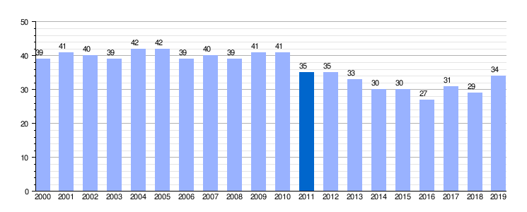 |
| Population (2000-2020) Residential population according to the Census
Population by local area census. |
See also

- For more information about Sandín for kids, check out the Spanish article: Sandín para niños
