Sandy Ridge, Pennsylvania facts for kids
Quick facts for kids
Sandy Ridge, Pennsylvania
|
|
|---|---|

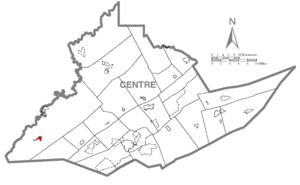
Location within Centre County
|
|
| Country | United States |
| State | Pennsylvania |
| County | Centre |
| Township | Rush |
| Area | |
| • Total | 0.64 sq mi (1.65 km2) |
| • Land | 0.64 sq mi (1.65 km2) |
| • Water | 0 sq mi (0.0 km2) |
| Elevation | 1,850 ft (560 m) |
| Population
(2010)
|
|
| • Total | 407 |
| • Density | 639/sq mi (246.7/km2) |
| Time zone | UTC-5 (Eastern (EST)) |
| • Summer (DST) | UTC-4 (EDT) |
| ZIP codes |
16677
|
| Area code(s) | 814 |
| FIPS code | 42-67872 |
| GNIS feature ID | 1186955 |
Sandy Ridge is a small place in Centre County, Pennsylvania, United States. It is known as a census-designated place (CDP), which means it's an area identified by the U.S. Census Bureau for statistical purposes. It's not officially a city or town with its own local government. In 2010, about 407 people lived here. Sandy Ridge is also part of the larger State College, Pennsylvania area.
Contents
Where is Sandy Ridge Located?
Sandy Ridge is found in Pennsylvania, specifically in the southwest part of Rush Township. It sits on land that is about 1,850 feet (564 meters) above sea level. This community is located a few miles northwest of a physical landform also called Sandy Ridge, which is a high point of the Allegheny Front.
How to Get Around Sandy Ridge
Two main roads pass through or near Sandy Ridge. Pennsylvania Route 970 goes through the community. If you follow it northwest for about 4 miles (6 km), you'll reach Osceola Mills. Pennsylvania Route 350 runs along the eastern edge of Sandy Ridge. This road can take you north about 6 miles (10 km) to Philipsburg. If you go south on Route 350, you'll cross the Allegheny Front and reach Interstate 99 at Bald Eagle in about 9 miles (14 km).
How Big is Sandy Ridge?
The U.S. Census Bureau says that Sandy Ridge covers a total area of about 1.65 square kilometers (which is about 0.64 square miles). All of this area is land, with no large bodies of water inside its boundaries.
Who Lives in Sandy Ridge?
In 2010, there were 407 people living in Sandy Ridge. These people lived in 170 households, and 129 of those were families. The area had about 247 people per square kilometer (or 620 people per square mile). Most of the people living in Sandy Ridge were White (99.8%).
What is the Age Range of Residents?
The population of Sandy Ridge includes people of all ages. About 19.7% of the residents were under 18 years old. About 7.4% were between 18 and 24, and 23.6% were between 25 and 44. A large group, 28.2%, were between 45 and 64 years old. Finally, 21.1% of the people were 65 years old or older. The average age in Sandy Ridge was 45 years.
How Do People Earn Money?
In 2010, the typical income for a household in Sandy Ridge was about $41,406 per year. For families, the typical income was higher, around $79,500 per year. The average income per person in the area was about $24,197. Very few people, about 2.5% of the population, were living below the poverty line. This included no one under 18 and no one over 64.
See also
 In Spanish: Sandy Ridge para niños
 | Jessica Watkins |
 | Robert Henry Lawrence Jr. |
 | Mae Jemison |
 | Sian Proctor |
 | Guion Bluford |


