Sangerville, Maine facts for kids
Quick facts for kids
Sangerville, Maine
|
|
|---|---|

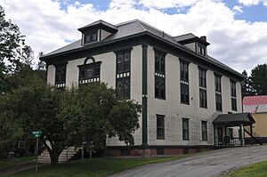
Town hall
|
|

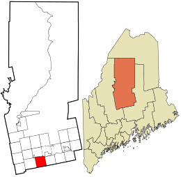
Location in Piscataquis County and the state of Maine.
|
|
| Country | United States |
| State | Maine |
| County | Piscataquis |
| Area | |
| • Total | 39.72 sq mi (102.87 km2) |
| • Land | 38.42 sq mi (99.51 km2) |
| • Water | 1.30 sq mi (3.37 km2) |
| Elevation | 505 ft (154 m) |
| Population
(2020)
|
|
| • Total | 1,306 |
| • Density | 34/sq mi (13.1/km2) |
| Time zone | UTC-5 (Eastern (EST)) |
| • Summer (DST) | UTC-4 (EDT) |
| ZIP code |
04479
|
| Area code(s) | 207 |
| FIPS code | 23-65865 |
| GNIS feature ID | 0582713 |
Sangerville is a small and friendly town located in Piscataquis County, Maine. In 2020, about 1,306 people called Sangerville home. The town got its name from Colonel Calvin Sanger, who was an important landowner in the area.
On June 14, 2014, Sangerville celebrated a big birthday! It was the town's 200th anniversary, also known as its bicentennial.
Contents
Exploring Sangerville's Location
Sangerville covers a total area of about 39.72 square miles (102.87 square kilometers). Most of this area, about 38.42 square miles (99.51 square kilometers), is land. The rest, about 1.30 square miles (3.37 square kilometers), is water.
Sangerville's Weather and Seasons
Sangerville has a type of weather called a humid continental climate. This means the town experiences all four seasons with big changes in temperature. Summers are usually warm or hot, and sometimes humid. Winters are cold, and can even be very cold with lots of snow.
| Climate data for Sangerville, Maine (1991–2020 normals, extremes 2009–present) | |||||||||||||
|---|---|---|---|---|---|---|---|---|---|---|---|---|---|
| Month | Jan | Feb | Mar | Apr | May | Jun | Jul | Aug | Sep | Oct | Nov | Dec | Year |
| Record high °F (°C) | 53 (12) |
59 (15) |
82 (28) |
86 (30) |
92 (33) |
96 (36) |
96 (36) |
91 (33) |
93 (34) |
84 (29) |
71 (22) |
58 (14) |
96 (36) |
| Mean maximum °F (°C) | 48.0 (8.9) |
46.4 (8.0) |
57.4 (14.1) |
72.2 (22.3) |
81.8 (27.7) |
86.6 (30.3) |
90.5 (32.5) |
87.3 (30.7) |
84.9 (29.4) |
73.5 (23.1) |
62.8 (17.1) |
51.3 (10.7) |
91.8 (33.2) |
| Mean daily maximum °F (°C) | 26.6 (−3.0) |
29.4 (−1.4) |
38.9 (3.8) |
51.1 (10.6) |
63.8 (17.7) |
72.7 (22.6) |
78.6 (25.9) |
77.8 (25.4) |
70.3 (21.3) |
56.9 (13.8) |
43.6 (6.4) |
31.6 (−0.2) |
53.4 (11.9) |
| Daily mean °F (°C) | 16.9 (−8.4) |
19.1 (−7.2) |
28.7 (−1.8) |
40.6 (4.8) |
53.2 (11.8) |
62.1 (16.7) |
67.8 (19.9) |
66.8 (19.3) |
59.1 (15.1) |
46.8 (8.2) |
34.9 (1.6) |
23.5 (−4.7) |
43.3 (6.3) |
| Mean daily minimum °F (°C) | 7.2 (−13.8) |
8.8 (−12.9) |
18.4 (−7.6) |
30.1 (−1.1) |
42.5 (5.8) |
51.4 (10.8) |
57.0 (13.9) |
55.7 (13.2) |
47.8 (8.8) |
36.6 (2.6) |
26.3 (−3.2) |
15.4 (−9.2) |
33.1 (0.6) |
| Mean minimum °F (°C) | −5.5 (−20.8) |
−5.0 (−20.6) |
0.5 (−17.5) |
18.5 (−7.5) |
30.7 (−0.7) |
40.6 (4.8) |
47.7 (8.7) |
46.6 (8.1) |
35.3 (1.8) |
26.5 (−3.1) |
12.8 (−10.7) |
−0.1 (−17.8) |
−9.0 (−22.8) |
| Record low °F (°C) | −17 (−27) |
−21 (−29) |
−8 (−22) |
8 (−13) |
24 (−4) |
33 (1) |
42 (6) |
42 (6) |
31 (−1) |
20 (−7) |
0 (−18) |
−16 (−27) |
−21 (−29) |
| Average precipitation inches (mm) | 3.06 (78) |
2.58 (66) |
3.06 (78) |
3.61 (92) |
3.76 (96) |
4.43 (113) |
3.45 (88) |
3.56 (90) |
3.54 (90) |
4.81 (122) |
3.61 (92) |
3.40 (86) |
42.87 (1,089) |
| Average snowfall inches (cm) | 16.5 (42) |
21.9 (56) |
14.3 (36) |
5.1 (13) |
0.0 (0.0) |
0.0 (0.0) |
0.0 (0.0) |
0.0 (0.0) |
0.0 (0.0) |
1.7 (4.3) |
7.6 (19) |
23.7 (60) |
90.8 (231) |
| Average precipitation days (≥ 0.01 in) | 8.3 | 8.3 | 8.6 | 11.5 | 11.9 | 13.4 | 12.0 | 11.6 | 9.0 | 12.6 | 9.8 | 11.6 | 128.6 |
| Average snowy days (≥ 0.1 in) | 7.9 | 7.3 | 5.1 | 1.7 | 0.0 | 0.0 | 0.0 | 0.0 | 0.0 | 1.0 | 3.3 | 8.7 | 35 |
| Source: NOAA | |||||||||||||
People of Sangerville
| Historical population | |||
|---|---|---|---|
| Census | Pop. | %± | |
| 1820 | 310 | — | |
| 1830 | 776 | 150.3% | |
| 1840 | 1,197 | 54.3% | |
| 1850 | 1,267 | 5.8% | |
| 1860 | 1,314 | 3.7% | |
| 1870 | 1,140 | −13.2% | |
| 1880 | 1,047 | −8.2% | |
| 1890 | 1,236 | 18.1% | |
| 1900 | 1,294 | 4.7% | |
| 1910 | 1,319 | 1.9% | |
| 1920 | 1,246 | −5.5% | |
| 1930 | 1,225 | −1.7% | |
| 1940 | 1,194 | −2.5% | |
| 1950 | 1,161 | −2.8% | |
| 1960 | 1,157 | −0.3% | |
| 1970 | 1,107 | −4.3% | |
| 1980 | 1,219 | 10.1% | |
| 1990 | 1,398 | 14.7% | |
| 2000 | 1,270 | −9.2% | |
| 2010 | 1,343 | 5.7% | |
| 2020 | 1,306 | −2.8% | |
| U.S. Decennial Census | |||
Population in 2010
In 2010, the census counted 1,343 people living in Sangerville. These people lived in 612 households, with 402 of them being families. The town had about 35 people per square mile.
Most of the people in Sangerville were White (96.8%). A small number were African American (0.4%), Native American (1.1%), or Asian (0.2%). About 1.3% of the population identified with two or more races.
In the households, 23.3% had children under 18 living there. More than half (52.4%) were married couples. About 14.1% of households had someone living alone who was 65 years old or older. The average household size was about 2.19 people.
The average age of people in Sangerville was 48.6 years old. About 18.2% of residents were under 18. About 20.3% were 65 years or older. The town had slightly more females (51.7%) than males (48.3%).
Famous People from Sangerville
- Hiram Maxim was an inventor born in Sangerville. He is famous for inventing the Maxim gun, which was the first machine gun that could reload itself.
- Sir Harry Oakes, 1st Baronet, was also from Sangerville.
See also
 In Spanish: Sangerville para niños
 | Aaron Henry |
 | T. R. M. Howard |
 | Jesse Jackson |

