Santa Bárbara de Heredia facts for kids
Quick facts for kids
Santa Bárbara
|
|
|---|---|
|
District
|
|

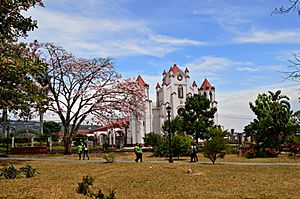
Santa Bárbara Plaza and Cathedral
|
|
| Country | |
| Province | Heredia |
| Canton | Santa Bárbara |
| Creation | 1889 |
| Area | |
| • Total | 1.27 km2 (0.49 sq mi) |
| Elevation | 1,140 m (3,740 ft) |
| Population
(2011)
|
|
| • Total | 5,944 |
| • Density | 4,680/km2 (12,120/sq mi) |
| Demonym(s) | Bárbeño |
| Time zone | UTC−06:00 |
| Postal code |
40401
|
| Climate | Am |
Santa Bárbara is one of the six districts in the Santa Bárbara canton in Costa Rica. People often call it Santa Bárbara de Heredia. It is the main town of the Santa Bárbara area, which means it's considered a city.
This city is a key place for business and travel. It's about seven miles from Heredia and five miles from Alajuela, which are both important provincial capitals.
Contents
History of Santa Bárbara
Before Spanish settlers arrived, the area of Santa Bárbara was home to the Huetares, an indigenous tribe. Their leader, King Cacique Garabito, ruled this land. When the Spanish came, they first named the area Churruca or Surruco.
In the late 1700s, nearby cities like Heredia, Barva, and Alajuela grew. As trade between these cities increased, Santa Bárbara became a useful waypoint, a place where travelers could stop. Even though it was still called Churruca or Surruco by many, the name Santa Bárbara for the municipality and canton first appeared in official papers in 1821.
Building the Community
The spot where the main plaza is now was once the center of four districts. A small church, called a hermitage, was built there in 1837. By 1846, about 1,500 people lived in the Santa Bárbara canton.
A priest would visit every Sunday. In 1852, a local resident named Pedro Saborío suggested building a larger Catholic church near the plaza. Construction of the main cathedral began in 1859, led by Bishop Joaquín Anselmo Llorente y Lafuente.
Official Recognition and Growth
The district of Santa Bárbara was officially recognized as a church parish by the government in December 1848. In 1855, Florentino Cortés became the first mayor of the district. The city of Santa Bárbara was officially founded in September 1889. It was first called a villa (a small town), but as more people moved there, it became a city.
Santa Bárbara's first public school opened in 1860. Tomás Redondo, a cobbler, gave the first lessons. Diego Trejos was the first official teacher.
Modern services arrived later. In 1896, the district got its first electric lighting. A power plant was built on the Porrosatí River in 1914 to provide electricity. Running water pipes were installed in Santa Bárbara in 1911.
Culture and Community
Santa Bárbara has a local branch of the Consejo de la Persona Joven, which means "Council of Young People." This group organizes activities and clubs for young people, like the United Canton Band.
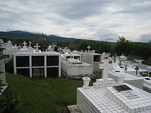
The city also has two cemeteries. The one on the west side has both tombs and burial spots. Many of the tombs have interesting old-style monuments.
A popular place to visit nearby is Ark Herb Farm. It's a botanical garden that focuses on growing and studying medicinal herbs.
Education in Santa Bárbara
The elementary school in Santa Bárbara is named after Juan Mora Fernández, a former head of state. It was built in 1951 on the west side of the main plaza.
The high school, Liceo de Santa Bárbara, started in 1973. It first used the elementary school's buildings but later moved to its own location about 800 meters from the central plaza.
The public library in Santa Bárbara opened in 1981. It closed for a few years in 1995 due to money problems but reopened in 2001 in the Salón Comunal, a community hall.
Sports in Santa Bárbara
Santa Bárbara is well-known for its sports teams, especially volleyball and soccer.
Volleyball Success
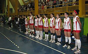
The city is home to the Asociación Deportiva Barbareña de Voleibol (ASBAVOL). This is the Santa Bárbara Volleyball Sports Association, and it's one of the most successful volleyball clubs in Costa Rica. Julio Alfaro, a former soccer player, started ASBAVOL in 1992.
Since 2005, ASBAVOL's top adult team has won the national championship five times. They also won eight gold medals in the National Sporting Championship. ASBAVOL's student team has won the Student Sporting Championship 13 times since 1996. They also won the Central American Student Sporting Championship twice. Many players from ASBAVOL also play for the Costa Rica women's national volleyball team. The gym at Liceo de Santa Bárbara is a common place for volleyball games.
Soccer Teams
Starting in 1943, a team called Club Sport Barbareño represented Santa Bárbara in the national soccer league's first division. In 1984, the team changed its name to Asociación Deportiva Barbareña.
This team has played in different levels of the Costa Rican soccer league. They were a third division team from 1962 to 1975. They played in the second division from 1975 to 1981, and again from 1993 to 1997. From 1997 to 2004, they were a first division team. In 2004, the team was sold and moved to Puntarenas, becoming Puntarenas F.C.. The team now plays in the third division at the Carlos Alvarado Villalobos Stadium in Santa Bárbara, which can hold 1,500 fans.
Another local team was Deportivo Machado F.C. They were rivals with Asociación Deportiva Barbareña for many years. When Deportivo Machado F.C. stopped playing in the mid-1980s, their players joined Asociación Deportiva Barbareña. Famous players like Abdulio Jiménez Araya and goalie Carlos "El Aguilucho" Alvarado played for these teams.
Geography of Santa Bárbara
Santa Bárbara covers an area of 1.27 square kilometers. It is located at an elevation of 1140 meters above sea level.
The city is part of the Greater Metropolitan Area of Costa Rica. Santa Bárbara is the smallest district in the Santa Bárbara canton. It is also the most central district within the canton.
Santa Bárbara is located in the Cordillera Central, which is a mountain range. Like many areas in Costa Rica, it is in a region that could be affected by natural events. The Potrerillos River flows through the northwest part of the district. The Quebrada Cruz forms the border between Santa Bárbara and the district of San Juan de Santa Bárbara.
Population Information
| Historical population | |||
|---|---|---|---|
| Census | Pop. | %± | |
| 1864 | 1,762 | — | |
| 1883 | 638 | −63.8% | |
| 1892 | 688 | 7.8% | |
| 1927 | 900 | 30.8% | |
| 1950 | 1,126 | 25.1% | |
| 1963 | 1,648 | 46.4% | |
| 1973 | 2,496 | 51.5% | |
| 1984 | 3,667 | 46.9% | |
| 2000 | 5,452 | 48.7% | |
| 2011 | 5,944 | 9.0% | |
|
Instituto Nacional de Estadística y Censos |
|||
According to the 2011 census, Santa Bárbara had a population of 5,944 people.
Transportation in Santa Bárbara
Roads for Travel
The district of Santa Bárbara has several important roads:
Most of the main roads in the canton start from Santa Bárbara's central plaza. Route 123, also known as Calle Las Americas, runs along the south side of the plaza. It starts in San Juan de Santa Bárbara and goes west towards San Pedro de Santa Bárbara and Alajuela.
Route 128 goes from the plaza towards Jesús de Santa Bárbara and Barva. Route 127 connects Santa Bárbara to Zetillal and San Bosco. Additionally, Calle Guapichelines begins in the northern part of the city.
See also
 In Spanish: Santa Bárbara (Costa Rica) para niños
 | Shirley Ann Jackson |
 | Garett Morgan |
 | J. Ernest Wilkins Jr. |
 | Elijah McCoy |


