Santa Claus, Georgia facts for kids
Quick facts for kids
Santa Claus, Georgia
|
|||
|---|---|---|---|

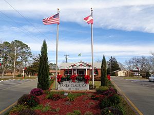
Santa Claus City Hall
|
|||
|
|||

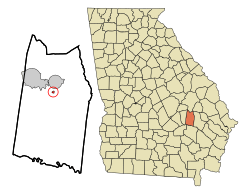
Location in Toombs County and the state of Georgia
|
|||
| Country | United States | ||
| State | Georgia | ||
| County | Toombs | ||
| Area | |||
| • Total | 0.18 sq mi (0.48 km2) | ||
| • Land | 0.18 sq mi (0.48 km2) | ||
| • Water | 0.00 sq mi (0.00 km2) | ||
| Elevation | 235 ft (72 m) | ||
| Population
(2020)
|
|||
| • Total | 204 | ||
| • Density | 1,108.70/sq mi (427.23/km2) | ||
| Time zone | UTC-5 (Eastern (EST)) | ||
| • Summer (DST) | UTC-4 (EDT) | ||
| ZIP code |
30436
|
||
| Area code(s) | 912 | ||
| FIPS code | 13-68600 | ||
| GNIS feature ID | 0322506 | ||
Santa Claus is a small city in Toombs County, Georgia, United States. In 2020, about 204 people lived there. It is part of the larger Vidalia area.
This city is special because many of its street names are related to Christmas. You can find streets like Candy Cane Road, December Drive, Rudolph Way, Dancer Street, Prancer Street, and Sleigh Street!
Contents
History of Santa Claus City
How the City Got Its Name
A local business owner decided to name this community after Santa Claus, the famous Christmas character. He hoped this fun name would bring many tourists to his pecan business and the motel next door.
When Santa Claus Became a City
Santa Claus officially became a city in 1941. This means it gained the power to govern itself.
Geography and Location
Where is Santa Claus Located?
Santa Claus is located at coordinates 32°10′15″N 82°19′52″W. It is very close to U.S. Route 1, a major highway.
Size of the City
According to the United States Census Bureau, the city is quite small. It covers an area of about 0.2 square miles (0.5 square kilometers). All of this area is land, with no water.
Population and People
How Many People Live Here?
The number of people living in Santa Claus has changed over the years. Here is a quick look at its population:
| Historical population | |||
|---|---|---|---|
| Census | Pop. | %± | |
| 1960 | 5 | — | |
| 1970 | 118 | 2,260.0% | |
| 1980 | 167 | 41.5% | |
| 1990 | 154 | −7.8% | |
| 2000 | 237 | 53.9% | |
| 2010 | 165 | −30.4% | |
| 2020 | 204 | 23.6% | |
| U.S. Decennial Census | |||
In 2000, there were 250 people living in Santa Claus. By 2020, the population had gone down a bit to 204 people.
See also
 In Spanish: Santa Claus (Georgia) para niños
 | Delilah Pierce |
 | Gordon Parks |
 | Augusta Savage |
 | Charles Ethan Porter |


