Santo Domingo, Peñuelas, Puerto Rico facts for kids
Quick facts for kids
Santo Domingo
|
|
|---|---|
|
Barrio
|
|

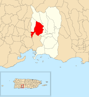
Location of Santo Domingo within the municipality of Peñuelas shown in red
|
|
| Commonwealth | |
| Municipality | |
| Area | |
| • Total | 4.01 sq mi (10.4 km2) |
| • Land | 4.01 sq mi (10.4 km2) |
| • Water | 0 sq mi (0 km2) |
| Elevation | 446 ft (136 m) |
| Population
(2010)
|
|
| • Total | 5,761 |
| • Density | 1,436.7/sq mi (554.7/km2) |
| Source: 2010 Census | |
| Time zone | UTC−4 (AST) |
Santo Domingo is a neighborhood, also called a barrio, in the town of Peñuelas, Puerto Rico. In 2010, about 5,761 people lived there.
Contents
Where is Santo Domingo?
This neighborhood is located near where some earthquakes happened in 2019 and 2020. It also experienced flooding after Hurricane Isaias in 2020.
A Look at Santo Domingo's History
Santo Domingo was listed in Spanish maps and records for a long time. After the Spanish–American War, Spain gave Puerto Rico to the United States. This happened because of the Treaty of Paris of 1898. Puerto Rico then became a territory of the United States.
In 1899, the United States Department of War counted the people in Puerto Rico. They found that 812 people lived in the Santo Domingo neighborhood at that time.
| Historical population | |||
|---|---|---|---|
| Census | Pop. | %± | |
| 1900 | 812 | — | |
| 1910 | 962 | 18.5% | |
| 1920 | 1,062 | 10.4% | |
| 1930 | 1,105 | 4.0% | |
| 1940 | 1,469 | 32.9% | |
| 1950 | 1,847 | 25.7% | |
| 1960 | 980 | −46.9% | |
| 1970 | 2,396 | 144.5% | |
| 1980 | 3,687 | 53.9% | |
| 1990 | 5,726 | 55.3% | |
| 2000 | 6,792 | 18.6% | |
| 2010 | 5,761 | −15.2% | |
| U.S. Decennial Census 1899 (shown as 1900) 1910-1930 1930-1950 1980-2000 2010 |
|||
The Santo Domingo Community
Santo Domingo is one of several communities that make up the Santo Domingo barrio. In the year 2000, the Santo Domingo community had 3,633 people living in an area of about 2.14 square miles (5.5 km2).
See also
 In Spanish: Santo Domingo (Peñuelas) para niños
 | Tommie Smith |
 | Simone Manuel |
 | Shani Davis |
 | Simone Biles |
 | Alice Coachman |


