Satsop River facts for kids
Quick facts for kids Satsop River |
|
|---|---|
|
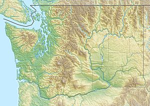
Location of the mouth of the Satsop River in Washington
|
|
| Country | United States |
| State | Washington |
| County | Grays Harbor |
| Physical characteristics | |
| Main source | Confluence of East and West Forks 47°2′11″N 123°31′38″W / 47.03639°N 123.52722°W |
| River mouth | Chehalis River 23 ft (7.0 m) 46°58′44″N 123°28′53″W / 46.97889°N 123.48139°W |
| Length | 6.5 mi (10.5 km) |
| Basin features | |
| Basin size | 291 sq mi (750 km2) |
The Satsop River is a stream located in the state of Washington, United States. It's not just one river, but a system of rivers. The main Satsop River is formed when two larger rivers, the East Fork and West Fork Satsop Rivers, join together.
The Middle Fork Satsop River also flows into the East Fork. These three "forks" are much longer than the main Satsop River itself. The main river flows south for only a few miles before it joins the Chehalis River near a town called Satsop, Washington.
Other important streams that feed into the Satsop River system include the Canyon River and Little River, which flow into the West Fork. Decker Creek flows into the East Fork. Most of these rivers start in the Olympic Mountains and the nearby Satsop Hills. These areas are mostly covered with thick forests. Some parts of the river's path are even inside the Olympic National Forest.
Contents
Where Does the Satsop River Flow?
The main Satsop River begins where its East and West Forks meet. From there, it flows south. It passes by the town of Satsop. Finally, it empties into the Chehalis River. This meeting point is about 20.2 miles up the Chehalis River.
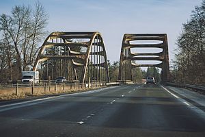
A major road, U.S. Route 12, crosses the Satsop River close to where it joins the Chehalis River. The main part of the river flows through a wide valley. This valley is often used for farming.
The West Fork Satsop River
The West Fork Satsop River starts high up in the southern Olympic Mountains. It flows south through a narrow, deep valley called a gorge. As it gets closer to the main Satsop River, its valley becomes wider.
This West Fork is the longest part of the Satsop River system. It stretches about 44 miles (71 km) long. If you measure from the very beginning of the West Fork to where the main Satsop River meets the Chehalis River, the total length is about 50.5 miles (81.3 km).
The West Fork has two main streams that flow into it: the Canyon River and the Little River. The Canyon River is about 20 miles (32 km) long, and the Little River is about 6 miles (9.7 km) long. Much of the land around the West Fork is privately owned timberland.
The East Fork Satsop River
The East Fork Satsop River begins where two smaller streams, Phillips Creek and Stillwater Creek, join together. It flows generally southwest. This part of the river moves through a wide, flat valley.
Bingham Creek is a major stream that flows into the East Fork from the north. Further downstream, Decker Creek and the Middle Fork Satsop River also join the East Fork, both coming from the north. The East Fork is about 21 miles (34 km) long.
The Middle Fork Satsop River
The Middle Fork Satsop River starts in the hills at the base of the Olympic Mountains. It flows south, cutting through steep gorges and canyons. This fork is about 35 miles (56 km) long, making it the second-longest part of the Satsop River system.
After Baker Creek joins the Middle Fork, its valley gets wider. This happens as the river gets closer to where it meets the East Fork Satsop River. Most of the land around the Middle Fork is covered with young forests. These forests are grown to be harvested for timber.
Decker Creek's Path
Decker Creek flows through wide, open grasslands and gently sloped valleys. It joins the East Fork Satsop River. This happens before the Middle Fork meets the East Fork. Decker Creek is about 16 miles (26 km) long.
How is the Land Around the Satsop River Used?
The land around the Satsop River is used in different ways. Here's a breakdown of who owns the land:
- About 62% is owned by companies, mostly for timber.
- About 18% is National Forest land.
- About 13% is owned by private individuals.
- About 6% is owned by the state government.
- Less than 1% is owned by cities and counties.
Most of the land in the Satsop River area, about 95%, is used for growing trees for timber. This includes both company-owned and National Forest lands. About 3% of the land is used for farming, like growing crops or raising animals. A small amount, just over 1%, is used for buildings, rural homes, or is barren land.
A Look Back: History of the Satsop River
The name "Satsop River" comes from the Upper Chehalis Native American language. It means "made stream." The Satsop people were a Native American group who lived along this river. They were neighbors with other groups like the Lower Chehalis, Humptulip, and Hoquiam peoples.
The Satsop people had a similar way of organizing their communities as their neighbors. Experts are still learning about how the Satsop people were related to other Native American groups. Some think they were a part of the Lower Chehalis. Others believe they were closer to the Upper Chehalis people. This is partly because their language dialect was very similar to the Upper Chehalis dialect.
The Upper and Lower Chehalis dialects were different. The place where the Chehalis and Satsop Rivers meet was the boundary between them. A special trail went through the Satsop lands. This trail was used for trading goods south to Grays Harbor and Willapa Bay.
Sadly, the Satsop people faced many challenges. Diseases like smallpox caused a huge decline in their population. After these events, the remaining Satsop people moved from their traditional lands along the Satsop River. They went to live on the Chehalis Reservation. In 1870, there were about 350 Satsop people. By 1885, that number had dropped to only 12. Today, there is no longer a specific Satsop tribe.
The first non-Native American settler on the Satsop River was John Rady in 1852. In the 1860s and 1870s, more settlers arrived. These included families from French Canada and Germany. The Schafer family, who moved from Wisconsin, were among these early settlers. Three brothers from the Schafer family started a logging company. It became one of the biggest and most successful logging businesses in the area. They began by using oxen to pull logs. Over time, their company grew to own large areas of forest. They even built miles of railroads to transport their logs.
Wildlife and Nature in the Satsop River
The Satsop River is an important part of the Chehalis River system. Especially in the summer, it provides a lot of water to the Chehalis River. For example, in August, about 30% of the water in the Chehalis River at Cosmopolis comes from the Satsop River.
The Satsop River and its smaller streams are home to many types of fish. These include different kinds of salmon. You can find Chinook, Chum, and Coho salmon here. The Middle Fork Satsop River is especially important. It has very large numbers of all three salmon species. The West Fork Satsop also supports many salmon. Other streams important for salmon to lay their eggs include Decker Creek, Canyon River, and the Little River.
People have worked on many projects to help the salmon in the Satsop River area. These projects include building special channels for salmon to lay eggs. They also include building fish hatcheries. Hatcheries are places where young fish are raised before being released into the river.
Forests and Logging Around the River
The land around the Satsop River is excellent for growing timber. A lot of this land is privately owned. Trees are regularly harvested here. About 70% of the forests in this area are less than 35 years old. This means they are relatively young, growing forests.
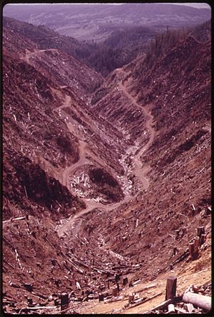
When trees are harvested, especially on steep slopes, it can lead to problems. There is a risk of soil washing away (erosion) and landslides. Also, there are many roads in the area, mostly for logging trucks. These roads can also increase the risk of erosion and dirt washing into the rivers. The region gets a lot of rain, from 70 to 175 inches (178 to 445 cm) each year. This heavy rainfall makes the danger of destructive erosion even higher.
 | Bayard Rustin |
 | Jeannette Carter |
 | Jeremiah A. Brown |


