Satterthwaite facts for kids
Quick facts for kids Satterthwaite |
|
|---|---|
 All Saints' Parish Church |
|
| Population | 215 (2011 Census) |
| OS grid reference | SD338923 |
| Civil parish |
|
| District |
|
| Shire county | |
| Region | |
| Country | England |
| Sovereign state | United Kingdom |
| Post town | ULVERSTON |
| Postcode district | LA12 |
| Dialling code | 01229 |
| Police | Cumbria |
| Fire | Cumbria |
| Ambulance | North West |
| EU Parliament | North West England |
| UK Parliament |
|
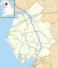
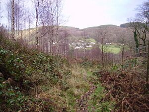
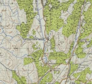
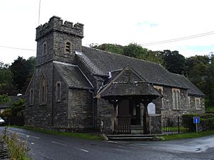
Satterthwaite is a small village in the Lake District, England. It's located in a valley called Grizedale, about four miles south of Hawkshead. The village has around 50 homes, a church called All Saints', and a Parish Room for community events. Satterthwaite is also a "civil parish," which is a type of local area with its own community website.
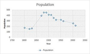
In 2001, about 257 people lived in Satterthwaite. By 2011, this number had gone down to 215. The population was highest in 1881, with 450 residents. Since then, it has slowly decreased. This drop in population is likely because people moved from the countryside to cities for work and other opportunities. In the 1870s, Satterthwaite was described as a village and a small church area within the larger Hawkshead parish in Lancashire.
Contents
Homes in Satterthwaite
Satterthwaite has many different types of houses. In 2011, there were 152 homes in the area. This was a bit less than the 166 homes counted in 2001. This change might mean that some houses were combined or changed into other kinds of buildings.
In 2011, 104 of these 152 homes had people living in them all the time. The rest might have been empty or used as holiday homes. Of the 152 homes, 68 were detached (standing alone), 57 were semi-detached (joined to one other house), 16 were terraced (part of a row), and 10 were flats.
Housing in the past was very different. In 1881, there were only 82 houses in total. After the Second World War, Satterthwaite grew as new people moved from cities to work in the forests. More recently, old barns have been turned into new homes. However, about half of the buildings in Satterthwaite village are now used as second homes or holiday homes.
Jobs in Satterthwaite
In 2011, 137 people aged 16 to 74 in Satterthwaite had jobs. Many residents work in highly skilled roles. For example, 29 people were managers or senior officials. The next most common job was in professional and technical fields.
About 20 people worked in skilled trades, like building or repairing houses. Another 12 people worked in caring, leisure, or other service jobs. There were also 18 qualified teachers. This shows that Satterthwaite has a variety of jobs, and many of them require good education and skills.
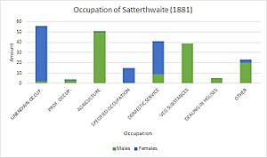
Comparing this to 2001, there were slightly more people working (145 total). The types of jobs have also changed a lot since 1881. Back then, most men worked in agriculture, which means farming. This was common because Satterthwaite is a rural area. Women in 1881 mostly worked in domestic services, like cleaning or cooking for families. These changes show how technology and education have created new types of jobs over time.
People of Satterthwaite
Most of the people living in Satterthwaite are white. In the 2011 Census, 213 out of 215 residents were white. Only one person was of mixed ethnicity, and one person was Asian. Almost everyone, 208 out of 215 residents, was born in the United Kingdom.
English is the main language spoken in 99% of homes. Christianity is the most common religion in Satterthwaite, with 135 residents identifying as Christian. About 52 residents said they had no religion.
Fun Places to Visit
Satterthwaite is surrounded by beautiful areas and has great places to visit. Some popular spots include Grizedale Forest Park, Graythwaite Woods, and Dale Park.
- Dale Park is perfect for outdoor activities like hiking and rambling.
- Grizedale Forest Park is a large area, great for cycling and walking on its many paths. It also has a campsite, which is a big attraction. Inside Grizedale, you can find Force Forge and Force Mill. The water from Force Beck flows out of the Grizedale Valley at Force Falls.
- Graythwaite Woods is located in the southeastern part of Satterthwaite Parish. While Graythwaite Hall itself is not open to the public, its beautiful gardens can be visited by tourists.
Land Use
Satterthwaite covers a total area of about 29,329 square meters. Most of this land is green space, like forests and fields. The area used for homes is about 21.31 square meters, and non-residential buildings take up about 14.65 square meters. Roads cover about 452.82 square meters, and there are also large public footpaths throughout Satterthwaite, covering about 3.86 square meters.
 | Shirley Ann Jackson |
 | Garett Morgan |
 | J. Ernest Wilkins Jr. |
 | Elijah McCoy |


