
Sault Ste. Marie Historic Commercial District facts for kids
Quick facts for kids |
|
|
Sault Ste. Marie Historic Commercial District
|
|

Ashmun Street, 1905
|
|

Location in Michigan

Location in the United States
|
|
| Location | Ashmun St. between Water and Easterday Sts., Portage Ave. between Brady and Ferris Sts., and Ashmun St. cross street blocks of Ridge, Maple, Arlington, Ann, and Spruce Sts., Sault Ste. Marie |
|---|---|
| Architectural style | Italianate, Late Victorian, Richardsonian Romanesque, and Commercial Brick, Neoclassical, Colonial Revival |
| NRHP reference No. | 100005683 |
| Added to NRHP | October 19, 2020 |
The Sault Ste. Marie Historic Commercial District is a special area in Sault Ste. Marie, Michigan. It's filled with old shops and businesses. This district was added to the National Register of Historic Places in 2020. This means it's an important place in history!
Some famous buildings are part of this district. These include the Old Federal Building and the Chippewa County Courthouse. Also, the Central Methodist Episcopal Church is here. The Adams Building and the Gowan Block are also in this historic area. Each of these buildings is important enough to be listed on the National Register by itself.
Contents
History of the District
Early Settlement and Growth
Sault Ste. Marie was first settled by people from Europe in 1668. For many years, either Britain or France controlled it. After the War of 1812, the border between Canada and the United States was set. It was placed along the St. Marys River.
As more people moved to Michigan's Upper Peninsula, Sault Ste. Marie grew. Its location was perfect because it was on the route around the river's rapids. This growth sped up in the 1840s when copper was discovered nearby.
Building the Locks and Expanding the City
In 1855, the first American lock was built here. This made it much easier for boats to pass through. At this time, the city's main business area was along Water Street. But it soon expanded to nearby Ashmun Street. In 1856, there were only 12 businesses. By 1879, there were 70!
The city really boomed in the 1880s and 1890s. Many new buildings were constructed. The main business area moved from Water Street to Ashmun Street for two big reasons. First, Fort Brady moved in 1892, which opened up land. Second, two huge fires in 1886 and 1896 destroyed many buildings on Water Street.
Modern Changes and Revival
In the early 1900s, a canal was built to create hydroelectric power. This helped the business district grow even more quickly. Building slowed down in the 1910s and 1920s. It slowed even more in the 1930s because of the Great Depression.
After World War II, construction picked up again. However, the downtown area started to decline in the 1950s and 1960s. People began to move away from the city center. But recently, a group called the Downtown Development Authority has worked hard. They have made the downtown area lively and important once more.
What the District Looks Like
The Sault Ste. Marie Commercial Historic District is the old business heart of the city. It also includes homes of early residents and business leaders. This district has 146 buildings in total. About 104 of these buildings help show the historical feel of the area.
Most buildings are two stories tall. They were built between about 1820 and 1968. However, most of them are from the late 1800s. You can see different styles of architecture here. Some buildings are Italianate or Late Victorian. Others are Richardsonian Romanesque or Commercial Brick. There are also Neoclassical public buildings. The houses are often simple or in the Colonial Revival style.
The main business blocks are along Ashmun Street. They stretch for five blocks south to the Power Canal. You'll also find them on the nearby blocks east and west along Portage Avenue. Even though it's mostly for businesses, the district also has government buildings and churches. There are also historic homes on Water and Bingham streets. Many of these old homes are now used as businesses.
Gallery
-
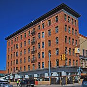
Adams Building
-
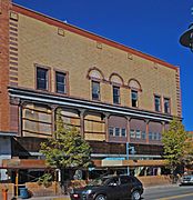
Gowan Block
-
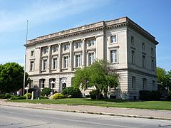
Old Federal Building
-
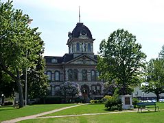
Chippewa County Courthouse
-
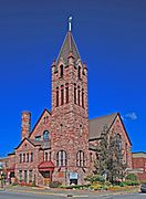
Central Methodist Episcopal Church
-
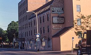
Ojibway Hotel
-
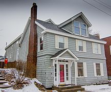
Allen House


.jpg)

