Schoharie Crossing State Historic Site facts for kids
|
Erie Canal
|
|
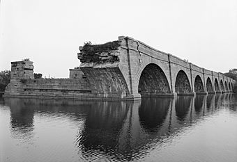
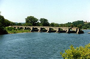
Nine remaining arches of the Schoharie Creek Aqueduct with the towpath on the right and the remains of the canal crossing on the left
|
|
| Nearest city | Fort Hunter, New York |
|---|---|
| Built | 1841–1845 |
| NRHP reference No. | 66000530 |
Quick facts for kids Significant dates |
|
| Added to NRHP | October 15, 1966 |
| Designated NHL | October 9, 1960 |
The Schoharie Crossing State Historic Site is a special place in Montgomery County, New York. It's also known as the Erie Canal National Historic Landmark. This site protects the old ruins of the Erie Canal aqueduct over Schoharie Creek. It also includes a 3.5-mile (5.6 km) part of the historic canal itself.
This area was the first part of the old Erie Canal to be named a National Historic Landmark. This happened before the entire New York State Barge Canal received the same honor in 2017. It's a great spot to learn about New York's past and how canals changed transportation.
Contents
A Look Back: History of Schoharie Crossing
Ancient Village and Fort Hunter
Long ago, a Native American village called Tiononderoge stood here. It was at the spot where the Mohawk River and Schoharie Creek meet. The name Tiononderoge means "the meeting of the waters" in the Mohawk language. People lived in this village from about 1710 until the American Revolutionary War began in 1776.
In 1710, Peter Schuyler, the mayor of Albany, invited Mohawk chiefs to visit Queen Anne in England. They wanted to strengthen their trading partnership. The Mohawk chiefs asked for help against the French. They also requested Anglican missionaries for their people.
The Mohawk also helped German refugees settle in New York. These Germans had arrived that year and needed a place to live. Mohawk leader Hendrick Tejonihokarawa offered land near the Schoharie for them.
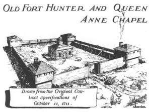
Because of the Mohawk's request, Queen Anne approved building Fort Hunter. It was named after Colonial Governor Robert Hunter and finished in 1712. The fort was a 150-foot square with a blockhouse at each corner. A wooden chapel, named after Queen Anne, was built in the center. She even sent special silver items for the chapel.
In 1741, Queen Anne's Chapel was rebuilt using strong limestone blocks from the area. By 1775, many Christian Mohawk people lived at Fort Hunter.
During the American Revolution, the Mohawk people sided with the British. They had been allies for a long time. After the war, the chapel was used as a tavern and stable. It helped house the many people moving west through the valley. The chapel was later torn down to make way for the Erie Canal.
The First Erie Canal
Building the Erie Canal started on July 4, 1817. The section of the canal through Fort Hunter was finished by 1822.
The original canal crossed the creek in a calm pool of water. This pool was made by a dam of logs and stones. Boats were pulled across this pool. Mules and horses were ferried over separately. Later, a bridge was built for the mules. However, boats still had to make the tricky crossing.
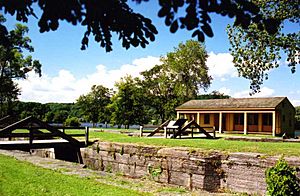
Schoharie Crossing State Historic Site is one of the few places where you can still see parts of the Original Erie Canal. It runs from the Schoharie Creek to the later Enlarged Erie Canal Lock 29. Along this path, you can find some important features.
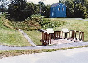
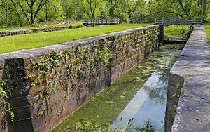
- A guard lock was built on the east side of the Schoharie Creek. This lock didn't raise or lower boats. Instead, it protected the canal banks from the creek's strong waters. The Fort Hunter guard lock is the only one left from the original canal. Some stories say it was built with stones from Queen Anne's Chapel.
- Further along, near Lock 29, is the Original Erie Canal Lock 20. This is the only lift lock remaining from the first canal. A lift lock raises or lowers boats between different water levels. It was carefully filled in during the 1980s to keep its stone walls from falling apart.
Both Lock 20 and the guard lock were filled with gravel in 1980 to help preserve them.
The Bigger and Better Erie Canal
Soon after the first Erie Canal was finished, it became too small for all the boats. By the 1830s, people decided the entire canal needed to be made bigger. This "Enlarged Erie Canal" was built between 1836 and 1862. The new canal was shorter overall, and it had fewer, but larger, locks. Many locks were "doubled," meaning they had two chambers side-by-side.
In Fort Hunter, the canal's path was changed. This allowed for a huge aqueduct to be built across Schoharie Creek. Construction on the Schoharie Aqueduct began in 1839 and finished in 1841. This amazing structure had fourteen arches and stretched 624 feet. It carried the Enlarged Erie Canal and its towpath over the creek from 1845 until 1916.
Over the years, some arches of the aqueduct were removed or collapsed. Six arches still stand today. The aqueduct was named a National Historic Landmark in 1960.
The Schoharie Crossing State Historic Site has many other parts of the Enlarged Erie Canal.
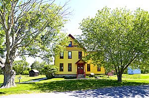
- "Yankee Hill" Lock 28 and Putman's Canal Store are located off Queen Anne Street. The lock was built in the 1840s. Putman's store was built in 1856 and served canal travelers until the early 1900s. You can find a small exhibit about canal stores inside the building.
- "Empire" Lock 29 is just east of East Church Street in Fort Hunter. It was built in the 1840s and is one of the best-preserved locks from the enlarged canal.
- Lock 30 was built in the 1840s. In 1956, this lock was filled in and paved over to make way for a road.
Schoharie Crossing State Historic Site Today
The Fort Hunter Canal Society started in the 1950s. Their goal was to save the old Erie Canal ruins in Fort Hunter.
In 1966, the state land at Fort Hunter became part of the New York State Office of Parks, Recreation and Historic Preservation. This is when the Schoharie Crossing State Historic Site was officially created.
The Visitor Center opened in 1987. It's located at 129 Schoharie Street in Fort Hunter. When the parking lot was first built, old stone walls were found. These were thought to be from the original Fort Hunter and Queen Anne's Chapel. In 2011, a flood washed away the parking lot, revealing even more of the fort's foundation!
A new exhibit called "Pathway to Empire: How the Erie Canal Helped Build America" opened in 2018. It celebrates the canal's 200th anniversary. This exhibit teaches visitors about the Erie Canal's history, from its first idea to how it's used today. The Visitor Center also has restrooms and a gift shop.
You can find a picnic area at Yankee Hill Lock on Queen Anne Street, near Lock 28 and Putman's Canal Store. There's also a boat launch and another picnic area at the end of Dufel Road, on the west side of Schoharie Creek.
See also
- Mohawk Upper Castle Historic District
- Schoharie Creek Bridge collapse, a modern example of the power of Schoharie Creek
- List of National Historic Landmarks in New York
- List of New York State Historic Sites
 | Roy Wilkins |
 | John Lewis |
 | Linda Carol Brown |


