Scotchtown, New York facts for kids
Quick facts for kids
Scotchtown, New York
|
|
|---|---|

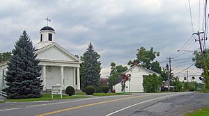
Church and other buildings at the historic center of Scotchtown, at Scotchtown Road and Alvaran Ln
|
|

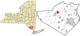
Location in Orange County and the state of New York.
|
|
| Country | United States |
| State | New York |
| County | Orange |
| Town | Wallkill |
| Area | |
| • Total | 4.85 sq mi (12.56 km2) |
| • Land | 4.84 sq mi (12.53 km2) |
| • Water | 0.01 sq mi (0.03 km2) |
| Elevation | 722 ft (220 m) |
| Population
(2020)
|
|
| • Total | 10,578 |
| • Density | 2,186.89/sq mi (844.31/km2) |
| Time zone | UTC-5 (Eastern (EST)) |
| • Summer (DST) | UTC-4 (EDT) |
| ZIP Code |
10941
|
| Area code(s) | 845 |
| FIPS code | 36-65882 |
| GNIS feature ID | 0964670 |
Scotchtown is a small community in New York, called a hamlet. It is also a CDP, which means it's an area defined for counting people by the government. Scotchtown is located in the Town of Wallkill, within Orange County, New York.
In 2020, about 10,578 people lived here. Scotchtown has its own ZIP Code, which is 10941. You can find it just east of the City of Middletown. It's part of a larger group of cities called the Poughkeepsie–Newburgh–Middletown Metropolitan Statistical Area.
Did you know that Scotchtown was almost the home of the famous 1969 Woodstock Festival? The festival was planned for the Mills Industrial Park here. However, the local government decided against it. So, the festival moved to Bethel instead, just a month before it happened.
Contents
Exploring Scotchtown's Location
Scotchtown is found at specific geographic coordinates: 41.4732 degrees North and 74.3663 degrees West. This helps us pinpoint its exact spot on a map.
How Big is Scotchtown?
According to the United States Census Bureau, Scotchtown covers a total area of about 4.2 square miles (which is about 10.9 square kilometers). All of this area is land, meaning there are no large bodies of water within its borders.
Understanding Scotchtown's Population
The number of people living in Scotchtown has grown quite a bit over the years. Let's look at how the population has changed:
| Historical population | |||
|---|---|---|---|
| Census | Pop. | %± | |
| 1970 | 2,119 | — | |
| 1980 | 7,352 | 247.0% | |
| 1990 | 8,765 | 19.2% | |
| 2000 | 8,954 | 2.2% | |
| 2010 | 9,212 | 2.9% | |
| 2020 | 10,578 | 14.8% | |
| U.S. Decennial Census | |||
As you can see, the population has increased steadily. In 2000, there were 8,954 people living in Scotchtown. By 2020, this number had grown to 10,578 people.
Who Lives in Scotchtown?
In 2000, there were 3,211 households in Scotchtown. A household is a group of people living together in one home. About 39% of these homes had children under 18 living there. The average household had about 2.78 people.
The population was spread out by age. About 27.7% of the people were under 18 years old. The median age was 35 years, meaning half the people were younger than 35 and half were older.
Discovering Michigan Corners
Michigan Corners is another small community very close to Scotchtown. It's also a hamlet and is located east of Middletown. You can find it where New York State Route 211 meets Goshen Turnpike.
The Story Behind the Name
There isn't a sign that says "Michigan Corners" today, but the name appears on local maps. There used to be a "Michigan Corners Deli" nearby, but it changed its name in 2007.
The story goes that the hamlet got its name from a man named Malcolm McLaughlin. Around 1825, he owed money and left town. When he came back, he told everyone he had been to Michigan. Later, McLaughlin opened a tavern in this spot. His neighbors started calling his tavern "Michigan," and the name stuck for the whole area!
See also
 In Spanish: Scotchtown (Nueva York) para niños
 | Calvin Brent |
 | Walter T. Bailey |
 | Martha Cassell Thompson |
 | Alberta Jeannette Cassell |


