Ashburn, Chicago facts for kids
Quick facts for kids
Ashburn
|
|
|---|---|
| Community Area 70 - Ashburn | |

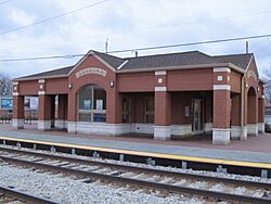
Ashburn station at 83rd Street and Central Park Avenue.
|
|

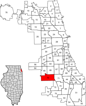
Location within the city of Chicago
|
|
| Country | United States |
| State | Illinois |
| County | Cook |
| City | Chicago |
| Neighborhoods |
list
|
| Area | |
| • Total | 4.87 sq mi (12.61 km2) |
| Population
(2020)
|
|
| • Total | 41,098 |
| • Density | 8,441/sq mi (3,259.2/km2) |
| Demographics 2020 | |
| • White | 10.1% |
| • Black | 45.0% |
| • Hispanic | 42.7% |
| • Asian | 0.8% |
| • Other | 1.3% |
| Time zone | UTC-6 (CST) |
| • Summer (DST) | UTC-5 (CDT) |
| ZIP Codes |
60652
|
| Median income 2020 | $71,951 |
| Source: U.S. Census, Record Information Services | |
Ashburn is one of Chicago's 77 community areas. It is located on the south side of the city. Ashburn covers almost five square miles. Its borders are roughly 72nd Street to the north, Western Avenue to the east, 87th Street to the south, and Cicero Avenue to the west.
Contents
History of Ashburn
Ashburn got its name because it was a place where the city's ashes were dumped. It grew slowly in the early 1900s. In 1893, a new area called "Clarkdale" was planned. It was near 83rd and Central Park Avenue. Only 19 homes were built there in the first 50 years. The first people to live in Ashburn were from Dutch, Swedish, and Irish backgrounds.
In 1916, Ashburn opened Ashburn Flying Field. This was Chicago's first airfield. It was home to the E. M. Laird Airplane Company. The airfield was marshy and closed in 1939.
After World War II, the area saw a big increase in population. This was due to a strong economy and many new babies being born. The nearby Ford City industrial area also helped. Homes were affordable, and it was close to the Chicago Loop. This made Ashburn a popular place to live in the 1950s and 1960s. Before Bogan High School was built, large piles of ash were visible in some areas.
Ashburn has different parts within it. The western part is called Scottsdale. It was named by a developer after his son, Scott. The middle part is known as Ashburn. The eastern part is called Wrightwood.
For a long time, most people in Greater Ashburn were Irish-Catholic. But in the 1990s, the area started to become more diverse. More African American families moved in. This led to some changes in the community's businesses.
In 1999, The New York Times wrote about Ashburn. They looked at how different groups of people lived together. Wrightwood, in the east, was the first part of the neighborhood to have a mix of people. It became mostly African-American. Ashburn itself became a mix of middle-class families. Many residents were firefighters, police officers, and teachers. Scottsdale, in the west, has mostly remained white.
A report in 2017 said that Ashburn was becoming more integrated. It was one of the few places in Chicago where the number of Black residents grew. This happened even when many Black people were leaving the city.
Neighborhoods in Ashburn
Beverly View
Beverly View is in the far eastern part of Ashburn. Its population was 996. Most residents were African American (82.4%). Others included White (14.3%), Hispanic or Latino (1.1%), Asian (1.1%), and Mixed Race (1.1%). Beverly View is bordered by West 79th Street to the north, 81st Street to the south and east, and Western Avenue to the west.
Wrightwood
Wrightwood is in the eastern part of Ashburn. Its population was 9,540. Most residents were African American (87.7%). Others included Hispanic or Latino (4.6%), Mixed Race (4.1%), and White (3.6%). Wrightwood is bordered by West Columbus Avenue to the north, 87th Street to the south, Western Avenue to the east, and Kedzie Avenue to the west.
Marycrest
Marycrest is in the east-central part of Ashburn. Its population was 541. Most residents were African American (80.6%). Others included Hispanic or Latino (16.4%) and White (3.0%). Marycrest is bordered by West 85th Street to the north, 87th Street to the south, Kedzie Avenue to the east, and Central Park Avenue to the west.
Parkview
Parkview is in the central part of Ashburn. Its population was 1,463. Residents included African American (54.1%), Hispanic or Latino (31%), White (14.2%), and Asian (0.7%). Parkview is bordered by West Columbus Ave to the northwest, Central Park Avenue to the east, Pulaski Avenue to the west, and 87th Street to the south.
Scottsdale
Scottsdale is in the far western part of Ashburn. Its population was 14,207. Residents included Hispanic or Latino (62.7%), White (22.7%), African American (12.7%), Asian (1.2%), and Mixed Race (0.5%). Scottsdale is bordered by Cicero Avenue to the west, Pulaski Avenue to the east, 77th Street to the north, and 87th Street to the south.
Greater Ashburn Development Association (GADA)
In 2016, the Greater Ashburn Development Association (GADA) was formed. Its goal is to bring the Ashburn community together. GADA works to build strong relationships between businesses and residents. They want to help the area grow and prevent problems.
Thanks to GADA, Ashburn had its first Summer Extravaganza. Over 500 people from the community attended. In 2017, GADA and the online neighborhood platform NEXTdoor/Ashburn won an award. They received the Good Neighbor Award from NEXTdoor. This award recognized their efforts to make their neighborhood stronger.
Transportation
METRA's SouthWest Service provides train service in Ashburn. Trains run Monday through Saturday. You can catch a train at the Ashburn and Wrightwood stations.
| Historical population | |||
|---|---|---|---|
| Census | Pop. | %± | |
| 1930 | 733 | — | |
| 1940 | 731 | −0.3% | |
| 1950 | 7,472 | 922.2% | |
| 1960 | 38,638 | 417.1% | |
| 1970 | 47,153 | 22.0% | |
| 1980 | 40,477 | −14.2% | |
| 1990 | 37,092 | −8.4% | |
| 2000 | 39,584 | 6.7% | |
| 2010 | 41,081 | 3.8% | |
| 2020 | 41,098 | 0.0% | |
Notable People from Ashburn
- John Martin Daley (1923–2015), a politician who lived in Ashburn.
- Ed Farmer (1949–2020), a radio sports announcer and former professional baseball player.
- Tim McCarthy (born 1949), a retired member of the United States Secret Service. He was injured while protecting President Ronald Reagan in 1981.
- Andrew J. McGann (1925–2008), a politician who served in the Illinois House of Representatives.
- Tom Tunney (born 1967), a member of the Chicago City Council. He grew up in Ashburn.
- Jim Zulevic (1965–2006), an actor and comedian.
Schools in Ashburn
Ashburn is home to many schools, including:
- Ashburn Community Elementary School
- CICS Wrightwood
- Carroll Elementary School
- Dawes Elementary School
- Durkin Park Elementary School
- Stevenson Elementary School
- Stevenson Middle School
- Lionel Hampton Fine & Performing Arts School
- Owens Scholastic Academy
- Ashburn Lutheran School
- St. Bede the Venerable Catholic School
- Sarah E. Goode STEM Academy
- St. Rita of Cascia High School
- William J. Bogan High School

